[Map] The Baltic States (March 1945)
The Baltic States
March 1945
For a live zoomable and pannable map of the Dome, you may follow this link.


Legend:
  • National colours as usual
  • De facto situation shown
  • Lighter Hue: Maximum territorial extension of the Baltic States
  • Red Arc: Dome Limit
  • Black Lines: Borders
  • Grey Lines: Internal Borders / Old Borders
  • Stars: Capitals
  • Circles: Other important cities

Key:
  1. Estonian territories annexed to the Russian S.F.S.R.
  2. Latvian territory annexed to the Russian S.F.S.R.
  3. Outer Vilnius Region (Lithuanian S.S.R.)
  4. Inner Vilnius Region (Lithuania)
  5. Inner Byelorussia (Poland, Inner Red Army control)
  6. Bialistok Region (Poland)
  7. Suwalki Region (Poland)
  8. Danzig (Germany)
  9. Pomerania (Germany)
  10. Corridor / West Prussia (Germany)
  11. Memelland (Germany)


The Baltic Confederation (Bold -- de facto control; Italic -- renounced de jure; Normal -- claimed):
  • LITHUANIA
    • Inner Lithuania Proper
    • Inner Vilnius Region
    • Memelland (ceded to Germany in 1939, recognized as part of Germany)
    • Outer Lithuania Proper (Soviet occupied, part of Lithuanian S.S.R.)
    • Outer Vilnius Region (Soviet occupied, part of Lithuanian S.S.R.)
    • Suwalki Region (recognized as part of Poland in 1945)
    • Parts of Inner Byelorussia (recognized as part of Poland in 1945)
    • Parts of Outer Byelorussia (recognized as part of Poland in 1945, Soviet occupied, part of Byelorussian S.S.R.)
  • LATVIA
    • Inner Latvia
    • Outer Latvia Proper (Soviet occupied, Latvian S.S.R.)
    • Latvian area annexed to the R.S.F.S.R. (Soviet occupied)
  • ESTONIA
    • Inner Estonia (2.4 hectares enclave ceded by Lithuania, not visible on this scale)
    • Outer Estonia Proper (Soviet occupied, Estonian S.S.R.)
    • Two Estonian areas annexed to the R.S.F.S.R. (Sovier occupied)
.
Note: The Outer Baltic Sea and the Oslofjord (not shown on the map) are completely cut off from the rest of the Oceans. Oslo, Stockholm, Helsinki, Leningrad, Tallinn, Riga, while outside of the Dome, cannot be reached by sea from the Outer Oceans. Outer Sweden and Finland are effectively landlocked.
 
[Map] Hungary (March-April 1945)
Hungary
March-April 1945
For a live zoomable and pannable map of the Dome, you may follow this link.


Legend:
  • National colours as usual
  • De facto situation shown
  • Lighter Hue: Territories claimed by Hungary
  • Red Arc: Dome Limit
  • Black Lines: Borders
  • Grey Lines: Internal Borders / Old Borders
  • Stars: Capitals
  • Circles: Other important cities
  • Horizontal Lines: Transleithania (1867-1918)


Key:
  1. Međimurje Region (annexed from Yugoslavia / Croatia in 1941, ceded to Croatia in March 1945)
  2. Prekmurje Region (annexed from Yugoslavia / Slovenia in 1941, ceded to Germany in March 1945)
  3. Sopron / Ödenburg Area (kept after the rigged 1921 plebiscite, ceded to Germany in March 1945)
  4. Inner Southern Slovakia (ceded by Slovakia in the First Vienna Award, 1938, reclaimed in 1945)
  5. Inner Eastern Slovakia (ceded by Slovakia after the Hungarian-Slovak War, 1939, ceded to Slovakia in January 1945)
  6. Outer Slovakia / Slovak A.S.S.R., Ukrainian S.S.R. (claimed by Hungary and Slovakia)
  7. Part of Outer Poland Proper / Polish Oblast, Ukrainian S.S.R. (claimed by Poland)
  8. Part of Inner Ukraine / Poland (claimed by the Soviet Union)
  9. Part of Northern Transylvania / Romanian S.S.R. (ceded by Romania in the Second Vienna Award, 1940, lost in 1944)
  10. Part of Northern Transylvania / Moldavian A.S.S.R., Romanian S.S.R. (ceded by Romania in the Second Vienna Award, 1940, lost in 1944)
  11. Part of Northern Transylvania / Hungarian A.R., Romanian S.S.R. (ceded by Romania in the Second Vienna Award, 1940, lost in 1944)
  12. Part of Hungarian A.R., Romanian S.S.R. (not part of the Second Vienna Award)
  13. Part of Hungarian A.R., Romanian S.S.R. (not part of the Second Vienna Award)
  14. Southern Transylvania, Romanian S.S.R. (not part of the Second Vienna Award)
  15. Bulgarian S.S.R.
  16. Western Banat / part of Vojvodina A.R., Serbia, Yugoslavia (not part of the 1941 annexations)
  17. Southern Bačka / part of Vojvodina A.R., Serbia, Yugoslavia (annexed from Yugoslavia / Serbia in 1941, lost in 1944)
  18. Southern Baranja / part of Croatia, Yugoslavia (annexed from Yugoslavia / Croatia in 1941, lost in 1944)
  19. Syrmia / part of Vojvodina A.R., Serbia, Yugoslavia (transferred from Croatia to Serbia in 1944)
  20. Dalmatia / part of Croatia, Yugoslavia
  21. Zara (Italian exclave under Yugoslav occupation)
  22. Cres (Italy, American occupation)
  23. Outer Istria (Italy, American occupation)
  24. Outer Venice (Italy, American occupation)
  25. Fiume (Italy, American occupation)
  26. Krk (Croatia, Yugoslavia, American occupation)
  27. Inner Istria (Germany)
  28. Burgenland (ceded to Austria in 1921, to Germany in 1938)
  29. Inner Croatia Proper
  30. Sudetenland (Germany)
  31. Austrian Silesia (Germany)
  32. Upper Silesia (Germany)


Hungary 1867-1918 / Transleithania, part of the Austro-Hungarian Empire (Bold -- still Hungarian):
  • Hungary 1941-1944 (Inner)
    • Inner Hungary Proper (Kingdom of Hungary)
    • Međimurje (1, Croatia)
    • Prekmurje (2, Germany)
    • Sopron / Ödenburg (3, Germany)
    • Southern Slovakia (4, Slovakia)
    • Inner Eastern Slovakia (5, Slovakia)
  • Hungary 1941-1944 (Outer)
    • Outer Hungary Proper (Hungarian People's Republic, Soviet Puppet)
    • Outer Eastern Slovakia (6, Ukraine, Soviet Union)
    • Carpatho-Ukraine (Ukraine, Soviet Union)
    • Northern Transylvania (9, 10, 11, Romania, Soviet Union)
    • Southern Bačka (17, Vojvodina, Serbia, Yugoslavia)
    • Southern Baranja (18, Vojvodina, Serbia, Yugoslavia)
  • Slovakia Proper (Slovakia)
  • Burgenland (28, Germany)
  • Southern Transylvania (12, 13, 14, Romania)
  • Western Banat (16, Vojvodina, Serbia, Yugoslavia)
  • Croatia
    • Outer Croatia Proper (Croatia, Yugoslavia)
    • Syrmia (19, Vojvodina, Serbia, Yugoslavia)
    • Inner Croatia (29, Croatia)
  • Fiume (25, Italy)
.
 
Last edited:
Señor Hilter certainly is working hard to ensure that he has no support from any German satellites of any note when the OKW comes knocking on the doors of the Führerbunker.
 
Even if Hitler would have treated his allies better, it is not concievable that they would have invaded Germany to help save his arse.
No, but I seriously doubt he's got anywhere to go in case he chooses to resist the coming coup.

Outside the Dome he'll be arrested, executed or assassinated if he has no government to back him up.

Inside...well, nobody's going to help hide him at this point. Even fascist Belgium will have an axe to grind with him, simply to get a longer leash from Germany. There's nobody left now that he hasn't fucked over, whereas previously Hungary had received much goodwill from the Nazis.

Since Hitler doesn't strike me as someone to step down when it's asked of him, odds are he'll go as in OTL, raving about traitors and Fegelein before he fellates his PPK one final time.
 
Due to the prolonged collaboration with the Fascists of the former Italian King Victor Emmanuel III, many Italians desired to replace the Italian Kingdom (Regno D'Italia) with an Republic (Repubblica Italiana). The conservatives favoured the Monarchy while, perversely, both the Communists and the Fascists preferred a Republic, albeit for diametrally opposed reasons. Geographically, the southern part of Italy was monarchist and the northern part republican.

To settle the issue and calm the spirits, an Institutional Referendum (Referendum sulla forma istituzionale dello Stato) was scheduled for the 10th of June. Naturally, Inner Italy was to take no part in the referendum as it was, for all intents and purposes, administratively severed from the rest of Italy. As the opinion polls showed a greater support for the Republic (53% vs. 39%), it appeared that the reign of the recently crowned King Umberto II would be a very short one.
I wonder if the cutting of Inner Italy, one of the most republican areas in the OTL referendum will impact it since OTL it was 45 v 55 and so with the loss of such support, how the referendum will end? Also given the earlier break in this timeline and the state of war with Nazi germany, the Westenrn Allies might fear a republic and so be less pro-republican? It's certainly going to be interesting either way since I believe it's going to be closer though I am not Italian and don't know too much
 
No, but I seriously doubt he's got anywhere to go in case he chooses to resist the coming coup.

Outside the Dome he'll be arrested, executed or assassinated if he has no government to back him up.

Inside...well, nobody's going to help hide him at this point. Even fascist Belgium will have an axe to grind with him, simply to get a longer leash from Germany. There's nobody left now that he hasn't fucked over, whereas previously Hungary had received much goodwill from the Nazis.

Since Hitler doesn't strike me as someone to step down when it's asked of him, odds are he'll go as in OTL, raving about traitors and Fegelein before he fellates his PPK one final time.
Your analysis is correct.

Hitler's fate will be interesting, unusual, bizarre, absurd and unexpected. At this pace of one chapter posted daily, that will be in about two weeks from now.

I wonder if the cutting of Inner Italy, one of the most republican areas in the OTL referendum will impact it since OTL it was 45 v 55 and so with the loss of such support, how the referendum will end? Also given the earlier break in this timeline and the state of war with Nazi germany, the Westenrn Allies might fear a republic and so be less pro-republican? It's certainly going to be interesting either way since I believe it's going to be closer though I am not Italian and don't know too much
That is correct. Moreover, I am a Monarchist.
 
That is correct. Moreover, I am a Monarchist.
This probably shouldn't surprise me given that around 40-50% of Romanians are monarchists (to my knowledge at least). And my analysis might've also been influenced by that I am a monarchist which in Czech is rare given our history with the last dynasty though since the end of communism, the Habsburg aren't as vilified or disliked with it being more neutral since our history with communism and Nazism made us realise that somethings are much worse than Habsburgs
 
This probably shouldn't surprise me given that around 40-50% of Romanians are monarchists (to my knowledge at least). And my analysis might've also been influenced by that I am a monarchist which in Czech is rare given our history with the last dynasty though since the end of communism, the Habsburg aren't as vilified or disliked with it being more neutral since our history with communism and Nazism made us realise that somethings are much worse than Habsburgs
We'll meet Otto von Habsburg later in the story.
 
Chapter 53. The Implosion of Switzerland


Note: See Chapter 47 for context.

For details, please check this previously posted Map of Switzerland.


3 March 1945

The Outer Cantons of Neuchâtel, Fribourg, Vaud, Geneva and Valais informed the Federal Government in Bern of their intention to organize a referendum in order to secede from the Confederation.


7 March 1945

Valais and Uri decided to exchange Inner Valais (15 km², no permanent population) with Outer Uri (25 km², no permanent population). The subsequent referendum passed with 99% in Valais and 78% in Uri. A small sum (20,000 Swiss Francs) was paid for the 10 km² difference in the exchanged territories.


13 March 1945

Outer Ticino (81.4% of area and 98% of population, almost all Italian speakers) and small Outer Graubünden (3.4% of area and 2% of population, almost all Italian speakers) announced their intention to:
  1. Split from Inner Ticino and, respectively, Inner Graubünden;
  2. Merge sparsely inhabited Outer Graubünden (population cca. 2,000) into Outer Ticino;
  3. Secede from Switzerland;
  4. Join (Outer) Italy.

Hitler was delighted. He commended the will of the Swiss people to separate into its constituent nations and unite with their brethren and expressed the hope that the Swiss Germans will also wish to unite with Germany.

In fact, both the desire of Outer Ticino and Outer Graubünden to unite with Italy and the proposed union of the Valtellina with Inner Switzerland were driven more by geography and less by national affiliation. The awkward position of the Dome's limit in relation with the Alps' crests created a situation in which those regions were no longer connected by road or rail with the rest of their countries but only with their neighbours. Practicality, not nationalism, was the force driving these people towards secession.


16 March 1945

Sparsely inhabited Inner Ticino (population cca. 3,000) proposed to join Graubünden.


18 March 1945

Taking advantage of the chaotic situation, the already restless French speaking people from the Jura Region of the Bern Canton pressed for self determination, secession from Bern and creation of a new Jura Canton.

The subsequent fate of the new Canton was unclear. Some residents from Outer Jura wanted to join the mostly Francophone proposed federation of the Outer Cantons, while some residents from Inner Jura wanted to secede from mostly Germanophone rump Switzerland altogether and perhaps join Inner France at a later date.


25 March - 29 April 1945

A sense of urgency (because of German encraochment upon Swiss sovereignty, impossibility to maintain traditional Swiss neutrality, difficult situation in isolated areas, etc) led to the unusual situation in which the all important referendums were held less than one month after being proposed.


Referendums in Neuchâtel, Fribourg, Vaud, Geneva and Valais

1. Do you want to secede from the Swiss Confederation?

Result: YES (67% in Neuchâtel, 58% in Fribourg, 79% in Vaud, 84% in Geneva, 70% in Valais).

2. Do you want to unite Neuchâtel, Fribourg, Vaud, Geneva and Valais into a new Federal Country?
Result: YES (91% in Neuchâtel, 97% in Fribourg, 97% in Vaud, 99% in Geneva, 86% in Valais).


Referendums in Outer Ticino and Outer Graubünden

1. Do you want to split the Canton of Ticino
(respectively Graubünden) in its Inner and Outer Parts as they are delimited by the Berlin Dome?
Result: YES (80% in Outer Ticino, 89% in Outer Graubünden).

2. Do you want to merge Outer Graubünden into Ticino?
Result: YES (98% in Outer Ticino, 87% in Outer Graubünden).

3. Do you want to secede from the Swiss Confederation?
Result: YES (77%).

4. Do you want to unite with Italy?
Result: YES (72%).


Referendums in Inner Ticino, Inner Graubünden and Inner Valtellina

1. Do you want to merge Inner Ticino into Graubünden?

Result: YES (83% in Inner Ticino, 81% in Inner Graubünden).

2. Do you want to reunite Inner Valtellina (Inner Italian Province of Sondrio) with Graubünden?
Result: YES (55% in Inner Graubünden, 69% in Inner Valtellina).

Despite the presence of numerous observers from Graubünden, the referendum in German occupied Valtellina was criticized as potentially rigged.


Referendums in Jura Region of Bern

1. Do you want to secede from Bern and form a new Jura Canton?

Result: YES (82% in Oter Jura, 64% in Inner Jura).

2. Do you want to split the Canton of Jura in its Inner and Outer Parts as they are delimited by the Berlin Dome?
Result: YES (60% in Outer Jura, 37% in Inner Jura). The decision of one of the parts to split was sufficient.

3. Do you want to secede from the Swiss Confederation and join the Swiss Federal Republic? (only in Outer Jura)
Result: YES (98%). However, the SFR did not allow Outer Jura to join as a distinct Canton due to its very small population (cca. 8,000) and proposed to have it join Neuchâtel instead.

4. Do you want to merge Outer Jura into Neuchâtel, part of the Swiss Federal Republic?
Result: YES (61% in Jura, 66% in Neuchâtel)

5. Do you want to secede from the Swiss Confederation? (only in Inner Jura)
Result: NO (58%).


Referendum in Bern Canton (without Jura)

1. Do you want to split the Canton of Bern in its Inner and Outer Parts as they are delimited by the Berlin Dome?
Result: NO (63%).


Nation-Wide Referendums (in rump Switzerland)

1. Do you want to expel the Canton of Graubünden from the Confederacy because of its annexation of Valtellina?
Result: NO (71%).

2. Do you want to join Germany?
Result: NO (between 90% in Bern and 59% in Thurgau). Germany protested alleged irregularities and, after some bickering, the Swiss agreed to rerun the referendum the following year.


Three months after the Berlin Dome split their country in half, Switzerland was no more.

Pre 1945 Switzerland
  • Swiss Federal Republic (Capital Geneva, Neutral, 96% French, 4% German)
    • Neuchâtel, including
      • Outer Jura
    • Fribourg
    • Vaud
    • Geneva
    • Valais, including
      • Outer Uri
  • Ticino (Capital Lugano, applied to join Italy, 100% Italian), including
    • Outer Graubünden
  • (Rump) Swiss Confederation (Capital Bern, German influence, 94% German, 2% French, 2% Italian, 2% Romansh)
    • Bern (ongoing activity to split the Canton)
      • Outer Bern
      • Inner Bern
    • (Inner) Jura (ongoing secessionist activity)
    • (Inner) Graubünden, including
      • Inner Ticino
      • Inner Valtellina (annexed from Inner Italy)
    • Basel
      • Basel-Stadt
      • Basel-Landschaft
    • Solothurn
    • Aargau
    • Zürich
    • Schaffhausen (Büsingen am Hochrhein de-enclaved, Verenahof annexed)
    • Thurgau
    • St. Gallen
    • Appenzell
      • Appenzell Ausserrhoden
      • Appenzell Innerrhoden
    • Glarus
    • Schwyz
    • Zug
    • Luzern
    • Unterwalden
      • Obwalden
      • Nidwalden
    • Uri, including
      • Inner Valais
.
There was a heated ongoing discussion in Italy whether to accept the proposed annexation of Ticino (Outer Ticino plus Outer Graubünden) which would, presumably, also imply a recognition of the loss of Inner Valtellina.


Although Rump Switzerland (under increasing German influence) had preserved the name and official recognition of the Swiss Confederation, it was the free and neutral Swiss Federal Republic (in theory a new State) which had preserved its substance.
 
[Map] Switzerland (March-April 1945)
Switzerland
March-April 1945
For a live zoomable and pannable map of the Dome, you may follow this link.


Legend:
  • National colours as usual (with the exception of the Swiss Cantons)
  • De facto situation shown
  • Red Curve: Dome Limit
  • Black Lines: Borders
  • Grey Lines: Internal Borders / Old Borders
  • Stars: Capitals (Bern, Geneva, Lugano)
  • Circles: Other important cities

Languages:
  • Plain background: German language area
  • Horizontal Lines: French language area
  • Vertical Lines: Italian language area
  • Checkerboard: Romansh language area (in Graubünden) or French-Italian bilingual (in Aosta)

Key:
  1. Outer Jura (seceded from Bern with Inner Jura, seceded from Jura, seceded from Switzerland, CH, joined Neuchâtel in the Swiss Federal Republic, SFR)
  2. Exchanged Bern and Fribourg exclaves (between CH and SFR)
  3. Inner Valais (to Uri, CH)
  4. Outer Uri (to Valais, SFR)
  5. Outer Graubünden (to Ticino)

Notes:
  • The Half-Cantons (Obwalden and Nidwalden, Basel-Stadt and Basel-Landschaft, Appenzell Ausserrhoden and Appenzell Innerrhoden, Inner Bern and Outer Bern) are shown together due to their traditional relation and convoluted borders with many exclaves in a rather small area.
  • Bisected Canton: Bern (split in half).
  • Valtellina is a former part of Graubünden, lost in 1797 to Napoleon's Cisalpine Republic. Inner Valtellina voted to rejoin Graubünden.
.
 
[Map] Switzerland (April-May 1945)
Switzerland
April-May 1945
Warning: This map includes a few unimportant spoilers.


Notes:
  • The Cantons of the Swiss Confederation (CH) are shown with different colours. Outer Bern is still part of it. Most of the CH is German speaking.
  • Jura (the only French speaking Canton of CH) has a significant degree of independence.
  • Graubünden (the only Canton with Italian and Romansh speakers and which had annexed Italian territory, Inner Valtellina, cca. 32,000 inhabitants) has a significant degree of independence.
  • Inner Lombardy has been provisionally transferred from German to Swiss administration as a new (temporary) Canton.
  • The other CH Cantons are German speaking.
  • The Cantons of the Swiss Federal Republic (SFR) are shown with the Swiss colour. Most of the SFR is French speaking.
  • Aosta has been added to the SFR as a new Canton (more in the relevant chapter).
  • Ticino (including Outer Graubünden) has joined Italy. Campione d'Italia was de-enclaved (more in the relevant chapter).


Swiss Federal Republic (6 Cantons, Capital Geneva, Neutral, 95% French, 4% German, 1% Italian)
  • Neuchâtel (French)
  • Fribourg (French + minority German)
  • Vaud (French)
  • Geneva (French)
  • Valais (French + minority German)
  • Aosta (French + minority Italian)

Swiss Confederation (18 Cantons, Capital Bern, German influence, 94% German, 2% French, 2% Italian, 2% Romansh)
  • German Switzerland / Deutsche Schweiz (15 Cantons, 19 including the Half-Cantons, almost 100% German)
    • Bern (Outer Bern and Inner Bern)
    • Basel (Basel-Stadt and Basel-Landschaft)
    • Solothurn
    • Aargau
    • Zürich
    • Schaffhausen
    • Thurgau
    • St. Gallen
    • Appenzell (Appenzell Ausserrhoden and Appenzell Innerrhoden)
    • Glarus
    • Schwyz
    • Zug
    • Luzern
    • Unterwalden (Obwalden and Nidwalden)
    • Uri
  • Jura (cca. 90,000 inhabitants, 98% French, 2% German)
  • Graubünden (cca. 167,000 inhabitants, 46% German, 30% Italian, 24% Romansh)
  • Inner Lombardy (cca. 12,000 inhabitants, 100% Italian)

Ticino (Italian Autonomous Province, 99% Italian, 1% other)
 
A small request, but could you make it "Elsaß-Lothringen", not the dirty French "Alsace-Lorraine"?
On international maps, I use English (international) names such as Alsace-Lorraine, Bavaria, Austria. After all, this is an English language forum.

On the administrative maps of Germany (soon to come), I will use German names such as Elsaß-Lothringen, Bayern, Österreich.

In any case, I use local names for cities (see Mülhausen in the above maps, for example).
 
Last edited:
I'm not entirely sure why Germany expected the Swiss to join them at this juncture.
 
[Map] NE Italy and Slovenia (March-April 1945)
North-East Italy and Slovenia
March-April 1945
Previous map from this series
For a live zoomable and pannable map of the Dome, you may follow this link.


Legend:
  • National colours as usual
  • "German" Grey: Germany "Proper" (Länder / Gaue, civil administration, German majority or significant minority)
  • Lighter Grey: Other territories (military administration, low or no German population)
  • Lightest Grey: Protectorates / "Autonomous" territories
  • De facto situation shown
  • Red Curve: Dome limit
  • Black Lines: Borders
  • Grey Lines: Internal Borders
  • Stars: Capitals
  • Circles: Important Cities

Key:
  1. Liechtenstein (annexed to Germany)
  2. Swiss Federal Republic (Canton of Valais)
  3. Italian speaking parts of Graubünden
    a. Annexed Inner Ticino
    b. Original Inner Graubünden
    c. Annexed Inner Valtellina (from Italy)
  4. Outer Graubünden (annexed to Ticino, then Italy)
  5. Outer Valtellina (Italy)
  6. Inner Lombardy (placed under temporary Swiss administration)
  7. Italian territory annexed directly to Germany (Carinthia / Kärnten, civil administration)
  8. Slovene territories annexed directly to Germany (Carinthia / Kärnten, civil administration)
  9. Slovene territory annexed directly to Germany (Styria / Steiermark, civil administration)
  10. Lower Styria / Untersteiermark
    a. Inner (part of the Protektorat Krain und Untersteiermark)
    b. Outer (part of Slovenia, Yugoslavia)
  11. Carniola / Krain
    a. Oberkrain (part of the Protektorat Krain und Untersteiermark)
    b. Unterkrain, Inner (part of the Protektorat Krain und Untersteiermark)
    c. Unterkrain, Outer (part of Slovenia, Yugoslavia)
    d. Innerkrain, Slovene part, Inner (part of the Protektorat Krain und Untersteiermark)
    e. Innerkrain, Slovene part, Outer (part of Slovenia, Yugoslavia)
    f. Innerkrain, Italian part, Inner (part of the Protektorat Krain und Untersteiermark)
    g. Innerkrain, Italian part, Outer (part of Istria, Italy)
  12. Prekmurje (annexed back from Hungary, part of the Protektorat Krain und Untersteiermark)
  13. Part of Prekmurje annexed directly to Germany (Styria / Steiermark, civil administration)
  14. Hungarian territory annexed directly to Germany (Styria / Steiermark, civil administration)
  15. Međimurje (annexed back from Hungary, part of Inner Croatia)
  16. Outer Hungary (People's Republic of Hungary)
  17. Krk Island (Croatia / Yugoslavia, American occupation)


Slovenia
  • Protectorate Carniola and Lower Styria / Protektorat Krain und Untersteiermark
    • 12, Prekmurje / Übermurgebiet
    • 10a, Lower Styria / Untersteiermark (Inner)
    • 11a, Upper Carniola / Oberkrain
    • 11b, Lower Carniola / Unterkrain (Inner)
    • 11d, Inner Carniola / Innerkrain (Inner)
    • 11f, Italian part of Inner Carniola / Innerkrain (Inner)
  • People's Republic of Slovenia, Yugoslavia
    • 10b, Lower Styria (Outer)
    • 11c, Lower Carniola (Outer)
    • 11e, Inner Carniola (Outer)
  • Annexed to Germany
    • 8, to Carinthia / Kärnten
    • 9, to Styria / Steiermark (with Maribor / Marburg an der Drau)
    • 13, to Styria / Steiermark
  • Claimed from Italy
    • 11g, Italian part of Inner Carniola / Innerkrain (Outer)
    • other parts of Italian Istria (Outer)
.

Germany
  • Civil Administration
    • Altreich (pre-1937 Germany)
    • Austria / Österreich, Ostmark
    • Sudetenland
    • Memelland
    • Danzig
    • Eupen-Malmedy / Eupen-Malmünd and other small areas annexed from Belgium
    • Maribor / Marburg an der Drau and other small areas annexed from Slovenia
    • Central Schleswig
    • Sopron / Ödenburg and other small areas annexed from Hungary
    • South Tyrol / Südtirol and other small areas annexed from Italy
    • Liechtenstein
    • some territories annexed from Poland
  • Military Administration
    • Luxembourg / Luxemburg
    • Alsace-Lorraine / Elsaß-Lothringen and other small areas annexed from France
    • Inner Trentino / Trient (may be transferred to the Italian Protectorate)
    • Austrian Littoral / Küstenland (Inner)
    • most territories annexed from Poland
  • Sui generis status
    • The Hirn
  • "Autonomous" Protectorates
    • Bohemia-Moravia / Böhmen und Mahren (Czech)
    • Carniola-Lower Styria / Krain und Untersteiermark (Slovene)
    • Inner Venice / Venedig (Italian)
  • Military occupation
    • Parts of Outer Norway (evacuating)
    • Inner Norway
    • Eastern Jutland and Western Funen (temporary)
  • Claimed areas (on a scale from 1 to 10)
    • Italian Outer Trentino (2)
    • Italian Outer Adriatic Littoral (7)
    • Yugoslav Outer Slovenia (4)
    • Inner German Switzerland (8)
    • Jura Canton (3)
    • Romansh speaking parts of Graubünden (6)
    • Italian speaking parts of Graubünden (4)
    • Outer Bern (4)
    • German speaking parts of Fribourg and Valais (3)
.
 
Chapter 54. Western Europe


France

The French people from Outer France, following the example of their Leader, were filled with righteous but ultimately impotent rage against not only the Nazis and their accursed Dome but also against their allies which, in their opinion, had betrayed them by entering peace negotiations with the Germans.

Their compatriots from Inner France did not have that luxury. Rage takes some effort and the Inner French preferred to use the little strength remaining in their undernourished bodies for more important activities like finding food, ensuring their personal safety and simply staying alive.

Abandoned by their own country and by the entire World in the sepulcral embrace of the Berlin Dome, the prospects of those unfortunate people were grim.
  • The whole region had been devastated the previous autumn by the advancing frontline and the scorched earth tactics of the retreating Germans.
  • The massive and unexpected overpopulation was a grave issue. Home of just four million people, Inner France unwillingly hosted another four million: the demobilized Inner Western Allied Armies, the Inner French Army, the Western Allied prisoners of war released by the Germans and simply dumped there, refugees from German occupied Alsace-Lorraine, etc.
  • The existing infrastructure was completely inadequate. The transport of people and goods was a nightmare.
  • There was not enough shelter for everybody. The military barracks were inadequate for long time habitation and the desperate local population was unwilling to share their homes with strangers.
  • The winter had been extremely harsh and the fuel for heating in short supply. Hundreds of people had frozen to death.
  • While, in theory, there should have been enough food for everybody (as per the Conditional Surrender Treaty, the Germans allowed food and medicine shipments to get in), its distribution was abyssmal. Large quantities of food simply rotted in storage or got lost on the way while many people were hungry or even starving.
  • With no clear State Authority, the region was plagued by anarchy and lawlessness, fuelled by the harsh conditions and the presence of an excess four million foreign young men. While most soldiers respected the authority of their superiors and were largely under control, about 130,000 were unaccounted for. Organized in gangs, those mob-like criminals terrorized the civilian population, stealing food and other goods, raping women and killing people with impunity.
  • The money supply was inadequate and many people resorted to bartering. The economy was completely disfunctional.
  • Sanitation was difficult and contagious diseases were common, especially venereal diseases.
  • Like elsewhere inside the Dome, hopelessness and depression were common. Inner France was virtually isolated, being almost completely surrounded by the Dome and by hostile territory (Nazi Germany and Degrelle's Belgium).

In those conditions, the leadership of the 240,000 strong Inner French Army, together with several local politicians, decided that being loyal to the Government in Paris had become a liability and the only solution to the crisis was to reach a separate accomodation with Germany.


11 April 1945, Nancy, Inner France

A group of French Generals and politicians issued a proclamation to the people of Inner France and to the wider World, announcing that:
  • Due to the intransigent actions of the French Government, which helped perpetuate the calamitous situation in their lands, Inner France was no longer under the authority of the French Government, while remaining French territory.
  • A separate French Government was formed in Nancy, to administer Inner France until such time when a single Government would be able to administer both Inner and Outer France.
  • The Nancy Government would immediately start negotiations with Germany in order to normalize the relations with its neighbour and allow the foreign soldiers to leave.

Charles de Gaulle declared that the so called Nancy Government was nothing more than a Nazi Puppet and asked his allies to not recognize its authority. The Allies were in no hurry to do that anyway.

Germany and the other countries under the Dome recognized the Nancy Government. Germany and Inner France began to negotiate immediately the much needed treaty. Just like Hungary, France was a split country, de facto if not yet de jure...


19 April 1945, Berlin, Greater German Reich

The Nancy Government of Inner France, the Sigmaringen Government in Exile of the French State, the Greater German Reich, Switzerland and Belgium signed a treaty summarized in the following points:
  • The Authority of the French State was recognized on all the territory of Inner France.
  • Maréchal Philippe Pétain was the Head of State and Pierre Laval the Prime Minister of the French State.
  • The Nancy and Sigmaringen French Governments were merged.
  • Nancy was declared the temporary capital of the French State.
  • The French State did not recognize the French Republic and claimed all its territory.
  • The French State recognized Alsace-Lorraine as part of the German Reich.
  • The French State ceded Briey-Longwy to the German Reich.
  • The French State ceded Togo, Kamerun and French Somalia to the German Reich.
  • The 1940 Armistice between the French State and the German Reich was renewed.
  • All French prisoners of war still in German Camps were to be immediately released.
  • There would be no German military presence in the French State.
  • The French State would maintain in Inner France an Army of no more than 50,000 men, with no tanks and no military airplanes.
  • The French State would be allowed to trade freely with Germany and the other friendly States.
  • The French State would be allowed to use the portuar facilities in Belgium for its trade for as long as the de facto territory of the French State remained landlocked.
  • The foreign soldiers demobilized in the French State would be allowed to leave the Dome via Switzerland, the evacuation to be completed in six weeks.

The 89 years old Maréchal Pétain became once again the leader of a part of France, separated from his long-time rival Charles de Gaulle by the impenetrable Berlin Dome.


Belgium

8 April 1945, Flanders, Belgium


The First Round of the Flemish Referendum asked the people of Flanders to choose from the following options:
  1. Unitary Kingdom (status quo)
  2. Federal Kingdom (Flanders as an Autonomous Federal State inside Belgium)
  3. Real Union between the Kingdom of Flanders and the Kingdom of Wallonia (Flanders as a separate Kingdom inside Belgium)
  4. Independence (Partition of Belgium in two countries, Flanders and Wallonia)
A fifth option, union with the Netherlands, was vetoed by Germany. In case no option would gather more than 50% of the ballots, a second round was to be held between the two most voted options.

Results:
  1. Unitary Kingdom: 6%
  2. Federal Kingdom: 41%
  3. Real Union: 25%
  4. Independence: 28%

The observers from the Netherlands, Switzerland and Denmark declared that the voting process had been mostly fair, although the electoral campaign had been marred by sporadic outbursts of violence. The second round of the referendum was held two weeks later.


22 April 1945, Flanders, Belgium

The Second Round of the Flemish Referendum asked the people of Flanders to choose between the following options:
  1. Federal Kingdom (Flanders as an Autonomous Federal State inside Belgium)
  2. Independence (Partition of Belgium in two countries, Flanders and Wallonia)

Results:
  1. Federal Kingdom: 48.84%
  2. Independence: 51.16%

With a difference of only 6,400 votes, Belgium was to be partioned. Germany, which had instigated the partition and had posed as supporter of the rights of their Germanic Flemish brethren, was delighted. The Netherlands were content and entertained hopes for a future union with Flanders. The rest of the World was rather wary but, regardless of that, most countries chose to recognize the democratically achieved independence of the new Nation.


24-30 April 1945, Brussels, Flanders

The mostly Francophone population of Brussels took to the streets, protesting the inclusion of their city in the new Dutch speaking country. A petition was signed asking for the secession of Brussels from Flanders and its union with Wallonia. Their grievances were ultimately not taken into consideration and the civil disturbances slowly died out. In the end, Brussels remained a mostly Francophone island inside Dutch speaking Flanders.


Belgium was officially partitioned in two Independent Kingdoms, Flanders (Vlaanderen) and Wallonia (Wallonie), joined in Personal Union by their common King, Leopold III of Flanders and Wallonia.


The new border created two exclaves, one Flemish in the north-east (bordered by Wallonia, Netherlands and Germany) and one Walloon in the south-east (bordered by Flanders, Inner France, France and Outer Flanders and split by the Dome in two unequal parts).

While the Flemish were unconcerned of their exclave (probably because they were used to the idea due to the Baarle-Herzog enclave complex), the Walloons negotiated a small exchange of territory with Inner France.

Wallonia ceded its small exclave to Inner France in exchange with a somewhat larger but less inhabited and mostly forested area adjacent to their common border. The minuscule Outer portion of the former exclave became part of Outer France. Outer Flanders remained de jure Flemish territory under French military occupation and administration.


Netherlands

The situation was stable. Except the emergence of a small but vocal movement campaigning for Union with Flanders (which had already been rejected by Germany), there were no other significant developments.


Norway

With the evacuation of Oslo in the second half of April, all of Outer Norway was free after five years of German occupation. The Norwegian Government in Exile returned to Oslo and the Puppet Government of Vidkun Quisling was moved to Kristiansand and put in charge of Inner Norway (which still had a small German military presence).

Norway was thus de facto split in five parts:
  • Outer Norway (except Finnmark) -- under the control of the legitimate Norwegian Government, with a Western Allied military presence;
  • Finnmark -- under Soviet military occupation;
  • Inner Norway (two exclaves separated by the Oslofjord) -- Vidkun Quisling's Government with a German military presence;
  • Svalbard and Jan Mayen -- under American military occupation;
  • The Norwegian Antarctic Territories (Bouvet Island, Peter I Island and Queen Maud Land) -- uninhabited.

After a short negotiation, the Soviet delegation surprisingly agreed to completely withdraw from Finnmark in six months. The only Soviet condition, to which the Norwegians agreed, was that Finnmark remained demilitarized.

The Americans reluctantly withdrew from Svalbard which remained demilitarized according to the still in force Spitzbergen Treaty. Jan Mayen and Peter I Island were sold to the United States and Bouvet Island and Queen Maud Land to the United Kingdom.

Inner Norway consisted of two parts, a larger western part around Kristiansand and a much smaller eastern part around Halden.

The Halden Triangle was difficult to reach, being almost completely surrounded by Inner Sweden (with Outer Norway on the other side of the Dome). The sea access was very limited and had no usable ports. In those conditions, the Germans wanted to get rid of the small and useless territory but creating openings in the Dome with the still hostile Outer Norway was out of the question.

After a series of unofficial consultations between the German, Swedish and Norwegian Governments, the remaining German troops left the Halden Triangle and Sweden took control of the area, placing it under temporary Swedish administration.

Sweden and Norway continued to discuss a possible swap of territory, with Sweden permanently annexing the Halden Triangle and Norway being compensated in Jämtland. The negotiations proved to be lenghty.
 
[Map] Western Europe (March-April 1945)
Western Europe
March-April 1945
Previous map from this series
For a live zoomable and pannable map of the Dome, you may follow this link.


Legend:
  • National colours as usual
  • De facto situation shown
  • Red Curve: Dome limit
  • Black Lines: Borders
  • Grey Lines: Internal / Older Borders
  • Stars: Country Capitals
  • Circles: Other important cities

Key:
  1. The current coastlines of IJsselmeer & Markermeer
  2. Baarle-Hertog "insanity"
  3. Flemish exclave (bordering Wallonia, the Netherlands and Germany)
  4. Outer Flanders (under French military occupation and administration)
  5. Outer Wallonian exclave (ceded to France, annexed by Outer France / the French Republic)
  6. Inner Wallonian exclave (ceded to France, annexed by Inner France / the French State)
  7. Inner French borderland ceded to Wallonia
  8. Eupen-Malmedy / Eupen-Malmünd (part of Germany)
  9. Briey-Longwy / Langich-Briey (to Alsace-Lorraine / Elsaß-Lothringen, Germany)
  10. Outer Bern (part of the Swiss Confederation / Schweiz)


Note: The Swiss Confederation (94% German speaking) and the Swiss Federal Republic (96% French speaking) are shown on the map (and usually referred to) as Schweiz and, respectively, Suisse, the names of Switzerland in their majority languages.
 
[Map] Central Europe (April 1945)
Central Europe
April 1945
For a live zoomable and pannable map of the Dome, you may follow this link.


Legend:
  • National colours as usual
  • De facto situation shown
  • Light Pink Hue: Dome area
  • Red Dot: Dome Centre (Berlin)
  • Red Circle (looks like an ellipse due to Mercator distortion): Dome limit
  • Black Lines: Borders
  • Grey Lines: Internal Borders


Key:
  1. Andorra (French-Spanish Condominium)
  2. Swiss Federal Republic / Suisse
  3. Jura (Swiss Canton)
  4. Graubünden (Swiss Canton)
  5. Ticino (Italian Special Region)
  6. Inner Lombardy (under Swiss Administration)
  7. Protektorat Venedig / Protectorate Venice / Inner Italy
  8. Protektorat Krain und Untersteiermark / Protectorate Carniola and Lower Styria / Inner Slovenia
  9. Croatia
  10. S. R. of Slovenia (Yugoslavia) / Outer Slovenia
  11. Istria, Fiume, Cherso / Cres
  12. Krk (American occupation)
  13. Zara (Yugoslav occupation)
  14. Felvidék / Upper Hungary / Southern Slovakia
  15. Halden Triangle (under Swedish Administration)
  16. Åland Islands


Note: There are no more active frontlines to be shown. World War II in Europe had de facto come to an end.
 
Last edited:
Well the one good point of this is that the Allied POWs are being allowed to leave, which will greatly reduce the bruden on the people of inner France. :) Their paid a heavy cost for it having to become a German satellite and being under Leval as well as the deep split that's been forced with outer France. However it will hopefully ease the humanitarian crisis there. The high death toll is probably only going to continue in the east. :(

I'm not sure that the Dutch would be interested in taking over the Flemish part of Belgium as it's largely Catholic and also slightly tied to the fascist movement which I expect will be deeply unpopular in the Netherlands. Especially since the German price for this would be [total] control by pro-fascist groups obedient to Berlin and even when fascists is reduced in Germany the latter won't go.
 
1. Well the one good point of this is that the Allied POWs are being allowed to leave, which will greatly reduce the bruden on the people of inner France. :) Their paid a heavy cost for it having to become a German satellite and being under Leval as well as the deep split that's been forced with outer France. However it will hopefully ease the humanitarian crisis there. The high death toll is probably only going to continue in the east. :(

2. I'm not sure that the Dutch would be interested in taking over the Flemish part of Belgium as it's largely Catholic and also slightly tied to the fascist movement which I expect will be deeply unpopular in the Netherlands. Especially since the German price for this would be [total] control by pro-fascist groups obedient to Berlin and even when fascists is reduced in Germany the latter won't go.
1. Laval and Pétain, while surely no democrats, were no bona fide fascists either.

With the recent ceasefire between the Inner Soviets and the Poles, the death toll has already been curbed. There are probably still some people starving but not on a large scale.

2. The democratic Dutch Government is not interested in annexing Flanders, at least not in the near future. The nationalist pressure groups are not very relevant.


Both the level of dependency upon Germany and the level of authoritarianism is very different in the various countries under the Dome. An approximative listing is provided below:

German military occupation: Inner Norway.
German control (from most to least): Croatia, Lithuania, Latvia, Slovakia, Hungary, Wallonia, Inner France, Flanders.
German influence (from most to least): Poland, Denmark, the Netherlands, the rump Switzerland, Sweden.

Dictatorships: Germany, Croatia, Inner Norway.
Authoritarian governments (from most to least): Wallonia, Hungary, Poland, Inner France, Slovakia, Flanders, Lithuania, Latvia.
Democracies: the rump Switzerland, Sweden, Denmark, the Netherlands.
 
Chapter 55. The Spread of Communism


Preamble

With the exception of the first chaotic years following the November 1917 Bolshevik coup d'état, when an "imminent worldwide Communist Revolution" was preached from Moscow, the official policy of the Soviet Union seemed to have been "Socialism in one country"¹.

1. If we disregard several internationally unrecognized Soviet Puppet States created on Chinese sovereign territory such as Outer Mongolia, East Turkestan and Tannu Tuva (the last one annexed in November 1944).


After nearly 17 years (1922-1939) of seemingly being content to develop inside the internationally recognized borders of the Soviet Union, the plague of Communism started to spread outwards, initially thanks to the Ribbentrop-Molotov Secret Pact and then, after the unsuccessful Axis invasion, helped by the relentless march westwards of the victorious Red Army. That is, until the Berlin Dome was activated and millions of Soviet soldiers became trapped inside it.

Realizing that his plan of conquering Germany and most of Eastern and Central Europe was no longer feasable, the Soviet Dictator Joseph Stalin decided to cut his losses short by consolidating his conquests and further expanding in other directions, especially towards the Mediterranean.


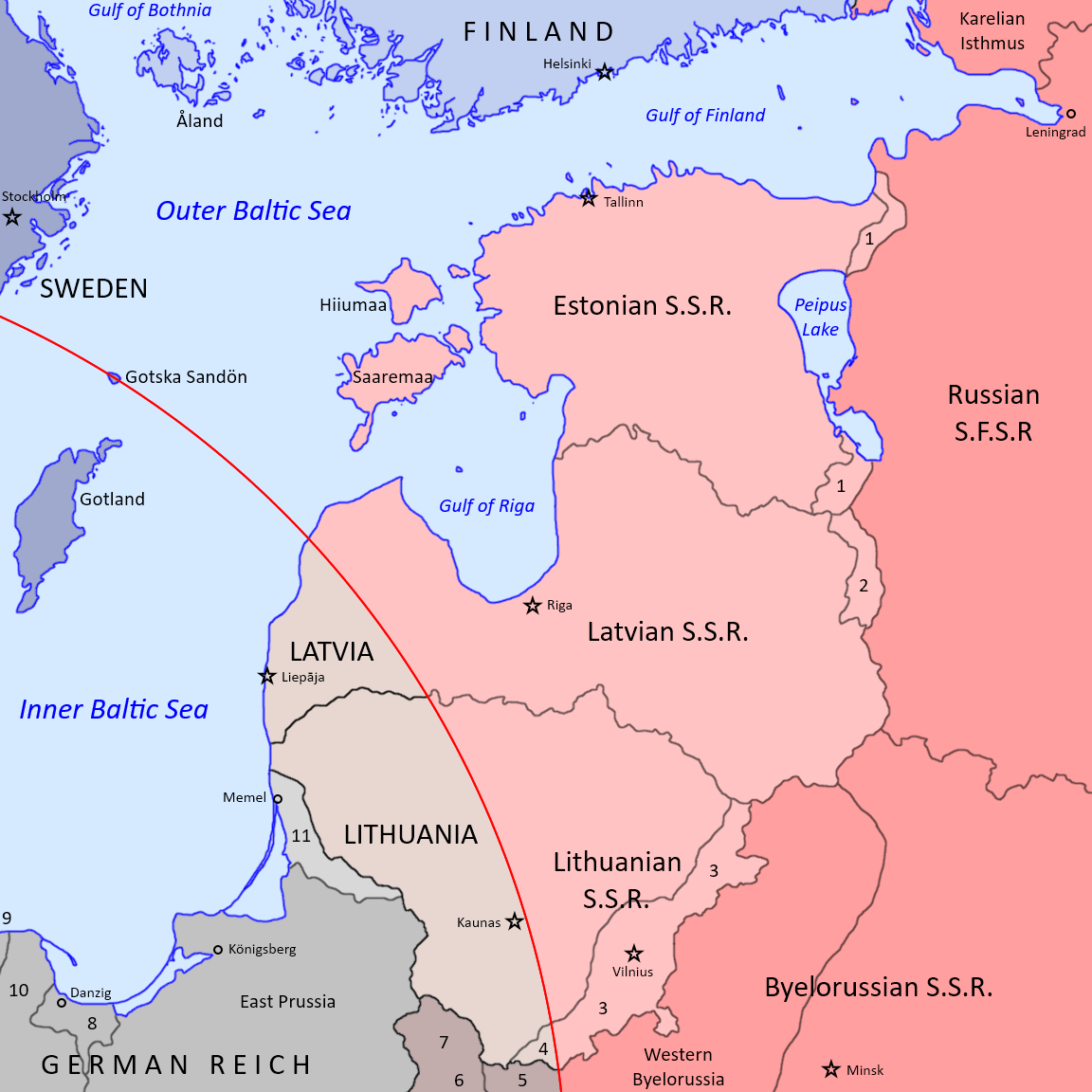
Short Timeline of Previous Soviet Expansion

Before 17 January 1945

  • All the internationally recognized territory of the Soviet Union (the interbellum Soviet borders)
  • Soviet Puppet States ("People's Republics") in China: Outer Mongolia and East Turkestan
  • Northern Iran -- Soviet Puppet States created: South Azerbaidjan and Magadan (Kurdish); ought to be vacated after the end of the War
  • Occupied Finnish territory -- annexed to the Russian SFSR
  • Occupied Norwegian territory (Finnmark) -- promissed to vacate it before the end of the year
  • Occupied Estonia -- annexed as the Estonian SSR (small areas to the Russian SFSR)
  • Occupied Latvia (with the exception of the still free Courland Peninsula) -- annexed as the Latvian SSR (small areas to the Russian SFSR)
  • Occupied Lithuania -- annexed as the Lithuanian SSR
  • Occupied Polish territory -- annexed to the Byelorussian SSR and and the Ukrainian SSR
  • Parts of Poland "Proper" -- a Soviet Puppet State (Polish People's Republic) was being set up despite the protests of the internationally recognized Polish Government in exile from London
  • Parts of Germany (East Prussia and Memelland) -- unspeakable atrocities commited by the Red Army
  • Occupied Eastern Slovakia (officially considered part of Czechoslovakia)
  • Occupied Carpatho-Ruthenia (officially considered part of Czechoslovakia) -- annexation to the Ukrainian SSR postponed until the end of the war at the request of the Czechoslovak Government in exile
  • Occupied Eastern Hungary -- a Soviet Puppet State (the Hungarian People's Republic) was considered
  • Occupied Romania -- parts annexed to the Ukrainian SSR, others made into a "Moldavian" SSR, whatever that may have meant!
  • Occupied Bulgaria
  • Parts of Yugoslavia -- under the control of the Yugoslav Communists ruled by Iosip Broz Tito
  • Italian Zara -- under the control of the Yugoslav Communists
  • Albania -- under the control of the Albanian Communists ruled by Enver Hoxha
  • Parts of Northern Greece -- Greek Civil War between the Greek Communists and the internationally recognized Greek Government

17 January 1945
  • Lost contact with almost three million Red Army men who found themselves trapped inside the Berlin Dome

After 17 January 1945
  • Occupied the Outer Courland Peninsula vacated by the Germans -- reannexed to the Latvian SSR
  • Lost ground in Inner Hungary and Inner Slovakia
  • Continued offensives in Inner Poland and Eastern Germany
  • Yugoslav Communist advances in Outer Croatia

February 1945
  • Annexed Romania as the Romanian SSR (merged with the "Moldavian" SSR), with a Moldavian ASSR and a Hungarian AR
  • Annexed Carpatho-Ruthenia to the Ukrainian SSR
  • Annexed Outer Poland "Proper" (three small exclaves) to the Ukrainian SSR
  • Annexed Bulgaria as the Bulgarian SSR, with a Macedonian ASSR and a Turkish AR
  • Annexed Outer Slovakia (one small sliver of land) to the Ukrainian SSR as a Slovak ASSR
  • Completely routed from Inner Hungary, Inner Slovakia, Inner Germany, Inner Latvia and Inner Lithuania
  • Lost ground in Inner Poland against the Polish Home Army
  • Yugoslav Communist completed conquest of Outer Croatia and Outer Slovenia (with the exception of Krk, under American control)
  • Soviet Puppet State (Hungarian People's Republic) proclaimed in Outer Hungary
  • Albanian People's Republic proclaimed in Albania
  • People's Federal Republic of Yugoslavia proclaimed in Yugoslavia (territory of Outer Croatia annexed to the Yugoslav Republics of Croatia, Bosnia-Herzegovia, Serbia, Montenegro)
  • Italian Zara annexed to Yugoslavia
  • Continued Greek Communist offensives in Northern Greece

Notes:
  • The Soviet Puppet States had no international recognition (Outer Mongolia, East Turkestan, South Azerbaidjan, Magadan, P.R. of Hungary)
  • The Soviet annexations had no international recognition (Estonia, Latvia, Lithuania, Outer Poland, Outer Slovakia, Carpatho-Ruthenia, Romania, Bulgaria)
  • The Soviet annexation of Finnish territory had not yet been confirmed in a peace treaty
  • The Yugoslav annexation of Zara had no international recognition


The Fall of Greece

Just like Yugoslavia and Albania (and unlike Romania and Poland for example), Greece had a large and powerful home grown Communist partisan movement which had fought against the Axis occupation for years.

After the complete evacuation of the Axis occupation forces, the emboldened and heavily armed Greek Communist partisans wanted to gain political power for themselves and their twisted ideology and thus continued their fight, that time against the lawful Greek Government and its rather reluctant British backers.

While the conflict between the Greek Communists (KKE and its military wing, the Democratic Army of Greece) and the legitimate Government of the Kingdom of Greece began in earnest just after the liberation of Greece in the autumn of 1944, one cannot speak of a bona fide Civil War until March 1945.

The historians have found several causes for the sudden precipitation of the simmering conflict into a full-fledged Civil War and the rapid success of the Communists:
  • the inability of the Western Allies to work out an understanding with the Soviets at Yalta (it had been speculated that Greece was supposed to be in the Western sphere of influence);
  • the Soviet desire to counter their setbacks in Central Europe and expand southwards instead, gaining an outlet at the Mediterranean Sea;
  • the souring Soviet-Turkish relations culminating in the Soviet promise of "Constantinople, Smyrna and other Greek lands" for a "Socialist Greece";
  • the half-hearted British support for the Greek Government due to the Western Allied unwillingness to provoke a war with the Soviet Union while still at war with both Germany and Japan.


26 March 1945

Before the low-level hostilities flared up into the Greek Civil War, the Communists controlled Thrace, most of Macedonia and the Epirus, parts of Thessaly and isolated areas elsewhere in Continental Greece while the Royal Government controlled the rest of the country (helped by small British forces in Athens, Piraeus, Crete and a few other places).

Rhodes and the Dodecanese was an Italian Colony under British occupation and it was understood that it would be transferred to a democratic Greece by the Peace Treaty with Italy. Cyprus was a British Crown Colony which was also promissed to Greece should it remain democratic and Western-alligned.


27 March 1945

The Greek Communists proclaimed a Hellenic People's Republic (People's Republic of Greece) in Grevena, a city in Macedonia firmly under their control. With the help of Yugoslav, Albanian and Soviet (mostly Bulgarian) "volunteers" the Greek Communists started a massive, coordinated attack against the Royalist forces still holding their ground in Northern Greece.


29-30 March 1945

The Communist forces captured Salonika. The Royalist Army began to rapidly disintegrate all over Continental Greece.


31 March 1945

The Greek Royalist Government asked the Soviet Union, Yugoslavia and Albania to cease the aggression against their country. The Communist powers recognized the Greek Communist Government in Salonika as the legitimate Government of Greece and removed their representatives from Athens.


1 April 1945

King George II of the Hellenes asked the British Ambassador for help. The British answer was evasive.


2-8 April 1945

A Royalist thrust towards Volos ended in disaster. Several thousands Royalist soldiers defected to the Communist side. The Royalist Army regrouped in Attica, leaving the rest of Continental Greece to the Communists.


10 April 1945

The People's Republic of Greece entered a military alliance with the Soviet Union, Yugoslavia and Albania and asked for military help against the Royalist forces.


12 April 1945

The Albanian People's Army entered Communist Greece, followed shortly by the Yugoslav People's Army. The Soviet Union declined to send the Red Army in Greece but allowed more Communist "volunteers" to cross the border and offered a considerable cache of weapons and ammunition as a gift to the new "brotherly Socialist state".


14 April 1945

The Kingdom of Greece declared war on Albania and Yugoslavia. The Communists seized Corfu.


19 April 1945

A Communist insurection flared up in Athens. Thousands of people were killed and more Greek troops defected, leaving the front lines in a precarious state.


22-25 April 1945

With the start of the Soviet-Turkish War², the geopolitical situation took a turn to the worse. Communist Greece declared war on Turkey and sent a token force into Turkish Thrace.

The Turkish Navy of the Aegean invaded Communist-held Lesbos and other minor islands of the Northern Aegean. That backfired horribly as the remaining loyalist Greek troops felt compelled to choose between two enemies: their fellow compatriots, the Greek Communists, and the eternal archenemy, the hated Turks. Most of them found the choice to be an easy one and the Greek Royalist Army started to fall apart.

2. The Soviet-Turkish War belongs in a dedicated chapter. You may speculate about it but I will not provide any more spoilers at this time.


26 April 1945

Although the Athens uprising was under control and the Capital was mostly secure, the Greek Government and the Royal Family decided to evacuate the besieged city. They relocated to the safety of Crete, followed by the small British units from Athens and Piraeus.


28 April 1945

King George II abdicated his throne under unclear circumstances and his brother Paul was crowned King of the Hellenes in Heraklion.


29-30 April 1945

King Paul asked the Greeks to stop the fratricide war and fight together against the Turks in order to liberate not only Lesbos but also Ionia and Constantinople. Afterwards, the King dismissed the Government and asked the Greek Communists to come to Athens to form a legitimate Government of National Union together with the other National forces.

The British seized the King in an unsuccessful attempt to limit the damage already done but it quickly became apparent that it was too late. A few hours later, Athens fell without a shot being fired.

An impromptu group of people declared the Independence of Crete and asked for British Protection, despite the non-existent popular support.


1-7 May 1945

The short Greek Civil War was virtually over. The Communists controlled all of Mainland Greece, the Peloponnese and most Greek Islands.

While the Greek Communists claimed the British held Crete, the still theoretically Italian Rhodes and Dodecanese and even British Cyprus, those islands were left alone for the time being, while they were still at war with Turkey.


The Aftermath

Nobody recognized the independence of the Cretan Republic, not even Great Britain itself.

The Communists included four representatives of the Greek democratic parties in their Government and allowed King Paul to remain on the throne with a referendum scheduled for October to decide upon the future form of Government.


The fall of Greece and the Soviet invasion of Turkey represented the beginning of the Second Red Scare in the Occident. The powerful Communist Parties of Italy and France were suddenly the public enemy number one as the Western Powers had no intention to allow any Western country to fall pray to Communism. The Communist partisans were hunted down, disarmed and sometimes arrested while powerful anticommunist propaganda was commonplace and the known Communists were kept under heavy police surveillance.

The odd war-time honeymoon between the Western Powers and the Soviet Union was over. Just like Fascism, Communism was the ideological enemy. Maybe even more then Fascism, as "moderate" Fascist (and rabidly anticommunist) States such as Franco's Spain began to be seen as somehow "acceptable" by the Western Leaders and the maleable public opinion.

The British Prime Minister Winston Churchil uttered an iconic phrase: the Cold War. Yes, the Free World was engaged in a new kind of war with the Soviet behemoth, a new strange ideological struggle devoid of direct military confrontation. A Cold War.

Should the situation in Germany have been different, Hitler would have been delighted.³

3. Another spoiler, duh. Well, this will have to wait a little. I will have to cover both other countries and Germany during parts of March and April until we finally get to May...
.
 
Last edited:
Back
Top