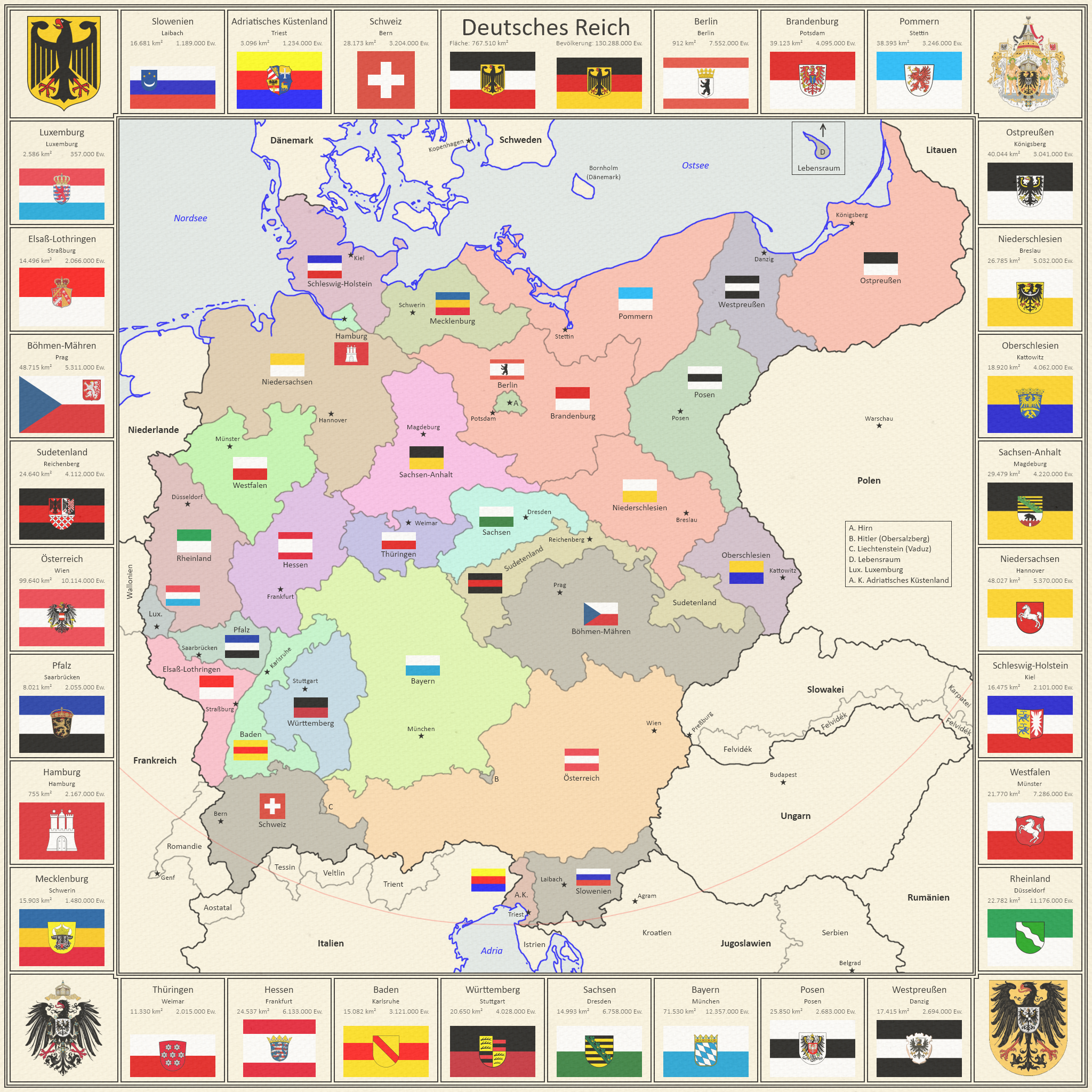
Caution : This map may contain a few spoilers.Legend :
Arbitrary colours for the various German States Red : Personal Union under King Hubertus of Prussia (Brandenburg, Pomerania, East Prussia, Upper Silesia)Dark Grey : The Autonomous States (Bohemia-Moravia, Slovenia, German Switzerland)Pink Curve : Dome limit (fully opened / deactivated)Black Lines : BordersGrey Lines : Internal Borders .
Key inside the map (in Poland).
German States (
Länder )
Berlin , BerlinBrandenburg , PotsdamPomerania (Pommern ), StettinEast Prussia (Ostpreußen ), KönigsbergLower Silesia (Niederschlesien ), BreslauUpper Silesia (Oberschlesien ), KattowitzSaxony-Anhalt (Sachsen-Anhalt ), MagdeburgLower Saxony (Niedersachsen ), HannoverSchleswig-Holstein , KielWestphalia (Westfalen ), MünsterRhineland (Rheinland ), DüsseldorfWest Prussia (Westpreuß en ), DanzigPosen , PosenBavaria (Bayern ), MünchenSaxony (Sachsen ), DresdenWürttemberg , StuttgartBaden , KarlsruheHesse (Hessen ), Frankfurt am MainThuringia (Thüringen ), WeimarMecklenburg , SchwerinHamburg , HamburgPalatinate (Pfalz ), SaarbrückenAustria (Österreich ), WienSudetenland , ReichenbergBohemia-Moravia (Böhmen-Mähren ), Prag (Praha )Alsace-Lorraine (Elsaß-Lothringen ), StraßburgLuxembourg (Luxemburg ), LuxemburgSlovenia (Slowenien ), Laibach (Ljubljana )Adriatic Littoral (Adriatisches Küstenland ), TriestGerman Switzerland (Schweiz ), Bern .
Special Districts (
Sonderkreise )
A. Hirn , NoneB. Hitler , ObersalzbergC. Liechtenstein , VaduzD. Lebensraum Island , Lebensraum .
Changes :
German Switzerland acceded to the German Reich.
Added border with Federal and State Coats of Arms, Flags, Names, Capitals, Areas, Populations.
Added paper texture and other visual effects.
.
Last edited: Feb 17, 2022