Red Lines: Frontlines before the start of the War (23 January 1945) Orange Lines: Frontlines on the day of the first Imperial nuclear strikes (15 February 1945) Cyan Lines: Frontlines before the Paris Ceasefire (12 March 1945) Missile Signs: Major German missile attacks (Belgrade and Budapest) Fire Signs: Major crude oil fires (Grozny and Baku) Nuclear Signs: Imperial nuclear strikes (nine), plus the Nuclear Test Site in the Nejd Poison Sign and Pink Area: The Danube toxic dump and the approximative affected area.
Field Marshal Rommel was faced with an impossible situation. The Heer was beaten on all fronts, the Luftwaffe was all but destroyed, the Reich Government was hostile, the Reich President was absent, the population was terrified and restless, the Nazi Party was opposing all political changes, the SS was actively sabotaging the peace process and the Americans were either unwilling or unable to support the Reich in any significant manner.
At the same time, the enemy was unstoppable. They could bomb any place in the Reich with virtual impunity, they could destroy entire divisions with nuclear fire and they could invade the Reich from three sides using their overwhelming superiority in soldiers, tanks, artillery, trucks, everything. If peace could not be achieved, the Reich was doomed. All they could do was to try and make the conquest of the Reich as costly as possible in the probably futile hope that the Empire would simply give up when faced with a stubborn defence and mounting casualties. However, it was clear that, by the time the Empire would even start thinking to give up, millions of Germans would be dead and the whole Reich in ruins.
Knowing all that, the OKW was frantically trying to salvage the peace process while preparing for a desperate last moment defence of the Reich.
The OKW indicated its willingness to accept all Imperial demands except the military occupation of the Reich (which meant the permanent loss of the Reich's sovereignty).
The complete and immediate evacuation of NE France, the Netherlands and the Baltic countries (NW Russia was evacuated during the talks);
Plebiscites to determine the "ethnic borders of the Reich" (in Alsace-Lorraine, Luxembourg, Bohemia-Moravia, Posen);
(Reasonable) Arms limitations (standing army, number of tanks, military aircraft, etc);
A total ban on ballistic missiles, nuclear, chemical and biological weapons, including future research in all those fields and the handover of everything related to those weapons, including raw and processed materials (uranium), existing weapons and parts thereof, research papers and blueprints;
A thorough dismantling of the Nazi Regime, a clear repudiation of its ideology and an acknowledgement of its crimes against the conquered peoples, the Empire and the environment;
The arrest and extradition to the Empire and to Russia of all those guilty of planning, ordering, aiding and abetting or executing war crimes;
Reparations (commensurate with the Reich's economic capacity), and others.
Imperial and neutral observers would be allowed to monitor the plebiscites and the enforcement of the arms limitations and of the ban on weapons of mass destruction.
While the deal seemed reasonable, the Empire rejected it because the Wehrmacht did not fully control the Reich yet and, even if it managed to subdue the SS and the Nazis in an acceptable timeframe, the adequate enforcement of (parts of) points five and six was far from guaranteed.
In the last days before the 13th of April expiration of the Paris Ceasefire, the resumption of full scale war seemed imminent. Thankfully, the negotiators finally realized that something less than an actual Imperial occupation of the Reich could actually work and be (borderline) acceptable to both parts. Imperial police and criminal investigators would be allowed to operate freely in the Reich (with the full suport of the Wehrmacht) in order to hunt down the SS, the top Nazis and other war criminals.
While that arrangement maintained the authority of the German State mostly intact and, thus, prevented the immediate manifestation of the Imperial Effect, the Empress was confident that, over time, more and more Germans would be converted, resulting in the continuous weakening of the Reich until it could be taken over from the inside. Later, the opening of the German archives revealed that the OKW suspected that the Reich would slowly lose its independence but they considered it preferable to a brutal military conquest of the Reich. Moreover, while the OKW could not convince the indoctrinated population to accept an unconditional surrender, the proposed arrangement was more palatable to those who didn't fully understand its implications.
With that difficult problem finally solved, the only hurdle to be overcome for the successful signing of the peace treaty remained the issue of legitimacy. The German Reich had a President (Rudolf Heß) who was totally apathetic and refused to cooperate with anyone, a Chancellor (Joseph Goebbels) who was a wanted war criminal and completely opposed to the treaty, a split Government (some Reich Ministers, like Albert Speer, had defected), a mass party (the Nazis) which had been ordered to dissolve but refused to do so, a powerful terrorist organization (the SS) with hundreds of thousands of fanatical members on the loose and, finally, the defeated Wehrmacht who had limited power and even more limited legitimacy,
An obvious solution would have been to allow the Wehrmacht sufficient time to strangle the SS and arrest the remaining Reich Government. However, that solution couldn't work because the Wehrmacht was reluctant to start an all out civil war with the SS before the peace treaty was actually signed and because the Empire rightfully feared that the SS planned more terrorist attacks.
Eventually, another compromise was reached. In order to increase the legitimacy of the peace treaty and to, hopefully, minimize the appeal of Goebbels' second stab in the back myth, Rommel proposed to hold a Reich-wide referendum asking the Germans to approve the peace treaty. Although it was expected that the referendum would be plagued by serious violence and probable rigging, it was still better than nothing and the Empire immediately jumped on the idea.
The Paris Ceasefire was extended for another month (until the 13th of May) during which time the Wehrmacht had to vacate all the remaining German conquests and organize the referendum. The text of the peace treaty was finalized on the 11th of April and widely disseminated in the Reich during the following days.
The Peace Referendum was held between the 29th of April and the 2nd of May, amid widespread violence which led to the deaths of at least one thousand people. The official results were published on the 6th of May (69% turnout, 77% YES vote).
The following day, the plenipotentiaries of the German Reich, the Empire of the Romans and the Russian Empire signed the Berlin Peace Treaty, which entered into force on the 8th of May 1945. Besides Anne, nobody noticed any coincidence.
The Late May Plebiscites in Alsace-Lorraine, Luxembourg, Posen and Bohemia-Moravia were overseen by Imperial, Swiss, Indian, Japanese and Nordic observers and yielded comfortable majorities in favour of remaining parts of the German Reich (87%, 84%, 94% and 81%, respectively).
The unexpectedly high percentages can be attributed to the following factors:
The turnout was low (between 53% and 61%) because of voter intimidation and overall chaotic and dangerous circumstances in the Reich.
The limited number of observers could not properly cover the entire territory and a certain amount of vote rigging had certainly occured.
Many "racially valuable" Frenchmen, Poles and Czechs had been "Germanized" and preferred their new ethnic identity because of opportunism or fear of retribution from their former conationals who viewed them as traitors.
Alsace-Lorraine and Luxembourg had clear German (Alemannic / Luxembourgish) majorities and they preferred the known limited oppression of the Reich to the unknown praeternatural danger represented by the Empire.
After five years of significant German colonisation, expulsion of most Poles to Poland and "Germanization" of the rest, Posen was more than 80% German.
The Protectorate of Bohemia-Moravia had been dissolved in 1943 and merged with the overwhelmingly German Sudetenland. More than half of the Czechs had been sold to the Empire (after the supply of Jews dried out in late 1943), Germans from elsewhere were moved in their place and about one third of the Czechs were "Germanized", leading to a German majority of at least 75%.
.
Details about the implementation of the other points of the Berlin Peace Treaty (started in early June) will be presented in a future chapter.
April - May 1945, Europe
The Empire followed the retreating Heer into north-western Russia, reaching Sankt Petersburg and the Finnish border on the 10th of April and completing the liberation of Russia two days later. Two weeks later, the border between Russia and Finland was slightly adjusted in favour of the former to allow the future growth of Sankt Petersburg. Nonetheless, after the border adjustment, the Finns still held more Russian land in the Karelian Isthmus than in the interwar period.
In May, the Imperial and Russian forces finally stormed the besieged Moscow and liberated most of the city in three weeks of apocalyptic urban combat which resulted in more than 90% casualties among the SS and almost 25,000 fallen Imperial and Russian soldiers. The remaining isolated pockets were starved or mopped up with minimal losses during the rest of the summer. Less than half a million starving and ghostly-looking barely alive Russians were found hidden amidst the smoldering ruins of the Russian Capital.
Between the 17th and the 28nd of April, the Empire easily took over the Baltic countries, with the small Estonian and Latvian armies offering a largely symbolic resistance. The Empire also occupied the West Estonian Island of Vormsi / Ormsö, which had been, at least in theory, Swedish territory since its 1941 annexation. The Swedes protested but quickly agreed to sell the island for some much needed oil.
Estonia, Latvia and Lithuania were annexed to the Empire as three separate Imperial States.
Between the 21st and the 30th of April, the Empire completed the takeover of France, including the French Capital Paris and the Autonomous Region of Wallonia. Since then, only 34 kilometres separated the Imperial Army in Calais from the British shore at Dover. In the Pyrenees, the Empire took Bayonne and Biarritz and stopped a couple of kilometres short of the Spanish border.
The Netherlands (including Flanders) were invaded on the 1st of May and fully occupied by the 5th. The Dutch resistance managed several attacks on the advancing Imperial Army but collapsed quickly after losing its support base. Because Anne hadn't yet decided on how to organize Western Europe, the Netherlands were temporarily placed under military administration.
In Tunisia, the Romanians tried to break the Allied defense lines but failed and were repulsed back to their initial positions after losing more than ten thousand men and dozens of tanks. Anne decided against using a nuclear bomb to break the stalemate because of the significant danger of losing both the bomber and the bomb.¹
1. Two out of the eight bombers used against the Germans had been shot down (one of which before deploying the bomb) and the air power of the Allies was significantly greater. Therefore, the Empire decided to only use nuclear bombs when in a critical situation, such as that when its long salient in southern France was in danger of being overwhelmed by the Allies. A solution to that problem was the use of ballistic missiles with (smaller) nuclear warheads (and a range of 800-1000 km), but that capacity was not expected before the end of the year.
On the 11th of May, the United Nations (the Allies) and the Nordic Union (Norway, Sweden, Denmark and Finland) signed the Lisbon Peace Treaty, ending the (almost entirely theoretical) state of war between them with the following main provisions:
The Nordic Union (a loose confederation of the four Nordic countries) was recognized as a subject of international law, with a common military, currency and foreign policy.
The current borders and the full and permanent neutrality of the Nordic Union were officially recognized (the last units of the Wehrmacht would leave the Nordic Union before the end of the month).
Svalbard and Franz Josef Land were recognized as demilitarized sovereign Norwegian territory (the Americans would vacate Svalbard before the end of the month).
Jan Mayen would be returned to Norway in one year.
Faroe would be returned to Denmark in one year.
The United States of America bought Greenland from Denmark and Bouvet Island, Peter I Island and Queen Maud Land from Norway (all three uninhabited Antarctic territories).
Denmark recognized and renounced all claims on the independent Republic of Iceland.
Besides the four above-mentioned countries, the Nordic Union also included five Autonomous Regions: Svalbard, Jan Mayen and Franz Josef Land (Norwegian), Åland (Swedish), Faroe (de jure Danish) and Eastern Karelia and Muurmani (Finnish). The three monarchs (King Haakon VII of Norway, King Gustaf V of Sweden and King Christian X of Denmark) and the Finnish President Carl Gustaf Emil Mannerheim were Co-Presidents of the Nordic Union. A limited central government was installed later that year in Gothenburg (Göteborg), the designated Federal Capital.
Various developments which took place in Africa, East Asia and the Pacific between January and May 1945 will be presented in the following chapters. More maps and infochapters will be also included.
Red Lines: Frontlines before the start of the War (23 January 1945), plus the former Finnish border in the Karelian Isthmus Violet Lines: Former demarcation Lines established by Paris Ceasefire (in NE France, NW Russia and Lithuania) Fire Signs: Major crude oil fires (Grozny and Baku) Nuclear Signs: Imperial nuclear strikes (nine), plus the Nuclear Test Site in the Nejd Pink Area: The approximative area affected by the Danube toxic dump
In order to focus on the German-Romanian War and related developments in Europe during the first months of 1945, we stopped reporting events from other parts of the World. However, that doesn't mean that nothing of interest happened outside Europe during that time. On the contrary, important changes took place in Africa, East Asia and the Pacific and elsewhere and we are going to cover them in this chapter and in the next one.
January - April 1945, Africa
The Imperial expansion in Africa continued unabated, despite the parallel war fought with the Reich in Europe. While usually considered a simple boast of Imperial strength (we are so powerful that having to fight the Reich in Europe does not dent our war capabilities in Africa), the continued operations in Africa had another, more important and urgent purpose. The Empire wanted to finish the conquest of Africa before the completion of the Manhattan Project complicated the matters and gave the Americans a chance to retain a foothold in West Africa and / or the Maghreb.
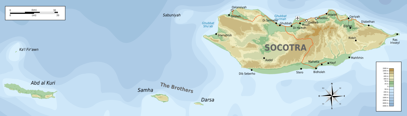
Socotra
Socotra, the last remnant of the once extensive British Arabian territories, was under the control of the US Navy, who was seriously hindering the Imperial traffic to and from the Gulf of Aden. That constituted a serious problem because both the trade with India and Japan and the Imperial Navy support on the East African Coast were hampered, with many commercial and military Imperial ships sunk or damaged.
The Empire had to take Socotra to remove the threat and allow both its commercial and its miltary fleet to pass safely through the Gulf of Aden into the Arabian Sea. However, Socotra was strongly defended by the Americans and the amphibious capabilities of the Empire used to be limited as the invasion of Sicily had proven. Therefore, besides frequent but not very effective bombing raids, the Empire had to live with that thorn in its side for several months. But, as soon as the recent expansion of the Imperial Navy, of the Marine and Landing Units and of the Paratroopers Corps allowed, an invasion of Socotra was planned for the end of February.
Socotra is situated about 300 km from the closest Arabian shore and 200 km from the easternmost point of Somalia, Cape Guardafui, over the Guardafui Channel. However, even those 200 km would have been too much if not for the presence of the smaller islands of the Socotra Archipelago dotting the entire breadth of the Guardafui Channel. Even so, the operation was very difficult and had to be preceeded by intense aerial and naval attacks to soften the American defences and allow the Romanian paratroopers to take Abd al Kuri on the 25th of February and Samha and Darsa on the 28th. Only then, with the south-western coast of Socotra just 30 km to the north-east, could the main phase of the operation be started.
Following sustained bombardments of the entire southern shore of Socotra, the Imperial amphibious forces landed between Dib Seberho and Stero, overwhelmed the American defenders and took control of the southern coastal pain of Socotra. While the landings and the fight on the beaches claimed over one thousand lives, in retrospect they were the easier part of the campaign, compared to the deadly slog across the granite spine of the island formed by the Hajhir Mountains. The crossing of the Hajhir took an entire week and resulted in over 3,500 casualties but, in the end, the Romanians broke through in the northern coastal plain and the Americans had to abandon the island during the following days.
The Empire annexed Socotra and added it to the Imperial State of Yemen as a Special Region.
East Africa
The American position in East Africa was plagued by difficult logistics (the farthest theatre of war from the United States) and the low priority allotted to the region by the American war strategists. The Americans simply couldn't spend their limited resources on a difficult to defend far away place with little strategic value, because those valuable resources were always needed in vastly more important places (the United Kingdom, the Iberian Peninsula, the Maghreb, West Africa and the Pacific).
Therefore, the American forces in East Africa were numerically insufficient, lacked armour and had poor morale. The Americans knew that holding the region was impossible but didn't evacuate it immediately because the East African Front tied a larger number of Imperial soldiers, who would have been otherwise free to fight in West Africa.
The Romanians attacked from three directions. In the north, between the Indian Ocean and Lake Victoria, they advanced in Kenya and Somalia, took Mogadiscio and Nairobi and entered Tanganyika from the north-east. In the centre, between Lake Victoria and Lake Tanganyika, they advanced eastwards, linking with the other thrusts in the north and south. In the south, between Lake Tanganyika and the Zambezi, they advanced quickly to Lake Nyasa, took the rest of Zambezia and the northern part of Nyasaland and then split in two, linking with the centre in the north and continuing on the left bank of the Zambezi in the south.
The last part of the operation saw continuous Imperial advance in Tanganyika and North Mozambique and little to no progress south of Lake Nyasa. Nonetheless, the Americans retreated steadily and were cut in two by a fast Imperial march to the Indian Ocean, following the course of the Rovuma River.
When the Americans finally decided to evacuate East Africa in late March, their control was limited to a small area around Mombasa and Dar es Salaam in the north and parts of Nyasaland and Northern Mozambique in the south. The evacuation started in early April and was successfully completed in twelve days, with less than 18,000 Allied soldiers being captured by the advancing Romanians in the last day of the campaign. The islands of Zanzibar, Pemba and Mafia fell in quick succession before the end of April, thus closing the East African campaign.
The Western Indian Ocean remained under Allied control because the Empire lacked the means to challange the American naval presence in the region (based in Diego Suarez, Madagascar). After the fall of France to the Empire, Madagascar became de jure independent, de facto a tightly controlled American Puppet. The Comoros and Réunion were annexed by the United Kingdom but remained under American military control, just like the old British Colonies of Mauritius and the Seychelles (which included the Diego Garcia Islands). Ceylon and the Maldives remained under Indian Protection (de facto full Indian control).
The Empire annexed the overwhelmingly Somali inhabited Northern Frontier District of Kenya and added it to the Imperial State of Somalia. Zanzibar was also annexed to the Empire (as an Autonomous Region of Somalia). The rest of East Africa, including North Mozambique, was annexed to the African Empire. South Mozambique remained under South African Protection (de facto part of South Africa, with the full blessing of the local Portuguese colonial authorities).
West Africa
The Empire made little overall progress in Nigeria, being stopped by the one kilometre wide Niger River (and its nigh impenetrable Delta), whose right bank was heavily defended by the Allies.
The former Spanish island of Fernando Pó was captured with air power alone in a surprise attack but the Portuguese islands of São Tomé, Príncipe and Annobón were too far from the mainland and remained under American control.
The Romanian armoured divisions continued their relentless westwards advance into the Sahara against no or limited Allied resistence, taking enormous tracts of useless desert, sparsely inhabited by Tuareg (Berber) nomads who seemed totally indifferent to the progression of the war.
On the Mediterranean Coast, the Imperial progress was much slower due to the presence of important Allied effectives defending on a narrow usable front between the Sea and the Desert and enjoying significant Allied naval support. The Romanians bypassed Tripoli and advanced to the Tunisian border, conquering the rest of Libya, then entered Tunisia and took its mostly deserted southern part as well as the island of Djerba and the small town of Gabès. The Americans evacuated their forces by sea from besieged Tripoli after nearly one month of almost non-stop bombardments which destroyed much of the city.
The subsequent Imperial advance in Tunisia fared rather poorly and, after a couple of bloody but inconclusive battles, the frontlines stabilized on the Tunisian Salt Lakes, south of the Atlas Mountains and immediately north of Gabès.
After the fall of East Africa and the end of the war with the Germany, the Empire began to relocate many of its armies to West Africa and the Maghreb, hoping to overwhelm the Allies and complete the conquest of the African Mainland before the end of the year. New military operations on a vast scale were planned for June.
April - May 1945, Worldwide
Until March 1945, the European colonies (and other territories) under Allied control were still officially United Nations Protectorates (the main former colonies of the enemy countries¹), under Allied Occupation (the minor colonies of the enemy countries) or under Allied Protection (the colonies of the allied countries²). 1. France, Italy, Spain, Denmark and Norway.
2. The Netherlands, Portugal and the United Kingdom.
The fall of France and the Netherlands to the Empire (during April) finally gave the Allies a reason to end that legal fiction and dispose of their remaining colonies. The offered reason for the change was that the independence of those countries was forever extinguished by the fall of their entire metropolitan populations to the Imperial Effect. The peace treaty between the Allies and the Nordic countries and the recent Imperial advance in Africa also changed the status of some territories.
A summary of the European Colonies (and other territories) in May 1945 is provided below. Territories remaining part of (or reverted to) the original possessor are formatted in bold. Territories recently taken over by the Empire are formatted in italics.
Denmark (Nordic Union; neutral)
Faroe [integral part of Denmark] (British occupation; would revert to Danish rule in May 1946)
Greenland (bought by the USA under duress)
Iceland (Independent country; American Client State)
. Norway (Nordic Union; neutral)
Svalbard and Franz Josef Land [integral parts of Norway] (relinquished to Norway)
Jan Mayen [integral part of Norway] (American occupation; would revert to Norwegian rule in May 1946)
Bouvet Island, Peter I Island and Queen Maud Land (bought by the USA under duress)
. Italy (Imperial control of the Mainland, Sicily and Malta)
Sardinia [integral part of Italy] (American occupation; Puppet Italian Government in Cagliari)
Libya (Imperial takeover in March)
(northern part of) Tunisia (American occupation; nominal independence)
. Spain (American occupation of the Mainland; Puppet Republican Government in Madrid)
Balearic Islands, Canary Islands, Ceuta, Melilla [integral parts of Spain] (American occupation)
Morocco (Independent country, American Client State)
Fernando Pó (Imperial takeover in April)
. Portugal (Allied country; American Client State)
Azores, Madeira, Cape Verde [integral parts of Portugal] (American control)
Bissau, São Tomé, Príncipe, Annobón (American control)
North Mozambique (imperial takeover in May; annexed to the Empire of Africa)
South Mozambique (de facto part of South Africa)
Portuguese India (annexed by India)
Macao, Portuguese Timor (Japanese control / Canton, Indonesia)
.
The Netherlands (Imperial control of the Mainland)
Dutch Government in Exile (dissolved in May)
Dutch Guiana (annexed by Brazil)
Dutch Caribbean (annexed by the USA)
Dutch East Indies (Japanese control / Indonesia, Papua)
. France (Imperial control of the Mainland)
Corsica [integral part of France] (American occupation; tentatively joined to Italian Sardinia)
Algeria [integral part of France] (American occupation; nominal independence)
(most of) French West Africa (American occupation; nominal independence as West Africa)
British Pacific Islands (divided into areas of American, Australian and New Zeelander control)
Sierra Leone, Gold Coast, (western) Nigeria (American control)
Socotra (Imperial takeover in March)
Burma, Malaya, Hong Kong, British Borneo (Japanese control / Burma, Thailand, Malaya, Canton, Indonesia)
Ceylon, Maldives (de facto part of India)
.
The following chapter will present the progression of the War in East Asia and the Pacific. More maps will follow, including an updated map of the Old World. An updated infochapter about the Empire and its States and an updated list of countries will be also posted at that time.
Orange Lines: Frontlines in January 1945. Fuchsia Lines: Remaining Allied holdings in East Africa at the start of the evacuation. Red Line: Proposed / future border between the Empire of the Romans and the Empire of Africa in West Africa (approximative limit between Berbers and Black Africans).
Yakutia and Tuva had several things in common: they were small (population-wise, under one million; Yakutia was huge in area), weak, independent, neutral, north-east Asian countries, sandwiched between the Empire and Japan. They were the only extant Soviet remnants (Tuva had been a Soviet puppet and Yakutia a Soviet Autonomous Republic), still ruled by the former Soviet bureaucracy who had outwardly rejected the communist ideology but had retained both their power and a largely socialist economic system.
Those two countries had so far escaped the attention of their powerful expansionist neighbours for several reasons: they had very little population and economic value, no known important natural resources and little strategic value (except in case of war between the Empire and Japan). Moreover, Yakutia was so much out of the way of everything, that a military conquest would have faced significant logistical hurdles. Currently, the Japanese were so overextended in China, that they didn't even consider the possibility of taking that huge frozen Yakut wilderness.
Both countries had proclaimed their independence and neutrality following the collapse of Soviet authority in the Far East during the Japanese invasion of Siberia. Later, after the Surrender of Russia, both the Empire and Japan had (in a hastily signed treaty) officially recognized their independence and neutrality and had pledged to support them, thus turning Yakutia and Tuva into official buffer states. However, nobody had asked the post-Soviet leadership of Yakutia and Tuva (much less the Russians, Yakuts and Tuvans living there) what they really wanted and that contributed to a minor crisis in the spring of 1945.
Yakutia was by far the least densely populated country in the world, with a little under half a million Yakuts and Russians (in almost equal proportions) spread on an area of more than three million square kilometres (about one third of the United States). Yakutia was also the coldest country on Earth, with an extreme continental climate and most of its territory covered by permafrost (Yakutsk was the coldest capital city in the World and the only one built on permafrost).
During the Japanese conquest of the Soviet Far East, amid the general collapse of Soviet power in all the surrounding territories, the Soviet leadership of the Yakut ASSR had proclaimed the independence and neutrality of Yakutia in order to prevent a Japanese invasion and not because of a genuine desire to secede from the Soviet Union. Continuing the policy of appeasement towards the staunchly anti-communist Japanese, Yakutia enacted superficial reforms which officially abolished the Soviet power and much of the trappings of the Communist system but maintained most of its substance. After the Surrender of Soviet Russia, the Empire helped the Russian Empire regain control of the lawless northern parts of the Krasnoyarsk Oblast and, in November 1944, Russia reached once again the western borders of Yakutia.
After contact between Russia and Yakutia was finally reestablished in early December, the leadership of Yakutia quickly realized that they needed not fear the Empire. Only those guilty of heinous crimes had been executed and most low and medium tier Soviet bureaucrats had been allowed to keep their positions in the new Imperial Russia. Moreover, as the Roman Empress had promissed, despite the return of capitalism, Russia had maintained most of its social(ist) policies such as free schooling and health care, worker's protection and benefits and some other progressive laws (some of which were actually correctly enforced for the first time). It was really the best of both worlds: a semi-socialist social system with a semi-capitalist economy and neither purges nor terror. For the former Soviet nomenklatura of Yakutia, the new Russia was too good to miss.
By mid-February, the Russian faction of the Yakutian collective leadership had managed to sideline some of the most prominent Yakut nationalists and to sway the ones inclined towards compromise, until support for a reunion with Russia became almost unanimous. On the 20th of February, when most of the Kwantung Army was engaged in the early stages of the last major operation against the Kuomintang (see below), Yakutia asked to join the Russian Empire as an Autonomous Grand Duchy with the Russian Tsar as its Grand Duke (similar to the situation of the Grand Duchy of Finland in the nineteenth century).
When the Japanese protested what they considered to be a breach of the treaty, Anne replied that, since neither the Empire nor Russia had intervened in any way in Yakutia, the letter of the treaty was not breached and the peoples of Yakutia and Russia had the sovereign right to unite in a single country if so they wished. Obviously, the Japanese were in no position to militarily challange the Empire and Yakutia was not worth a war anyway but the honour of Japan demanded some sort of compensation. Because a territorial compensation was out of the question, a monetary one was quickly discussed, which would, hopefully, allievate the enormous Japanese trade deficit with the Empire.
Because the Empire was not willing to cover the entire (unreasonable) amount asked by Japan, the latter sweetened the deal by adding to the offer at first the tiny neutral Tuva (160,000 inhabitants) and, later, some of the areas recently annexed to Buryatia (the troublesome Russian-majority city of Irkutsk and the rest of the Irkutsk Oblast, except Ust-Orda Buryatia and the rest of the western shore of the Baikal Lake). The Buryat puppet government in Ude was actually pleased to get rid of Irkutsk and the other areas with almost no Buryat population in order to strengthen the ethnic Buryat character of the state.
The new treaty was finalized after almost two months of difficult negotiations and entered into force on the 18th of May. The accession of Yakutia to the Russian Empire as an Autonomous Grand Duchy became official and the Japanese Army finished the evacuation of Irkutsk and of the other ceded areas before the end of the month. The Russian Army marched into Tuva and entered Kyzyl unopposed on the 23rd of May. The following day, Tuva was annexed to Russia as a second Autonomous Grand Duchy. According to a secret clause of the treaty, in order to placate the Japanese nationalists, the Russian Autonomous Areas in Chita, Blagoveshchensk, Birobidzhan, Khabarovsk and Vladivostok were dissolved.
Thus, in just three months, Russia pushed its borders with thousands of kilometres both westwards and eastwards, doubling in size and population from 6,852,000 km² and 43 million inhabitants to 13,425,000 km² and 82 million inhabitants. In preparation for a future merging with the Roman Empire, the Russian Empire became a federal country including four Federal Kingdoms, Northern Russia (capital Sankt Petersburg, 9 oblasts), Western Russia (capital Moscow, 13 oblasts), Central Russia (capital Nizhny Novgorod, 16 oblasts) and Siberian Russia (capital Omsk, 19 oblasts), and the two Autonomous Grand Duchies, Yakutia and Tuva.
February - May 1945, China
Japan's military situation was far from ideal. In the Pacific, they were constantly losing islands, space and ships and the Americans were getting closer to the Japanese Home Islands, their bobming raids increasing in both frequency and deadly efficacy. And what would happen when the Americans would start using nuclear weapons, destroying their cities one by one? In the west, the expansionist Roman Empire was a potentially very dangerous threat, capable of quickly taking large swats of East Asia if war were to break out between the former allies. Obviously, Japan could do close to nothing against either the Americans or the Romanians but they could try and close the Chinese Front by finally taking Chungking and breaking the Kuomintang.
In Chungking, the mood was sombre. The Chinese were completely isolated, they had lost three quarters of their country to the enemy, lacked ammunition and modern weapons, knew that the Japanese were coming and knew that they had become powerless to stop them. Of course that the Kuomingtang could go underground and continue the fight as partisans, as they already did in Occupied China, but actually holding the frontlines around a definite area in which the Independence of China was maintained and affirmed, that was no longer possible. Nonetheless, the Kuomintang decided to keep fighting to the end. No peace was possible with the Japanese, who wanted nothing less than the total destruction of China and its peoples.
The Kwantung Army started its Final Offensive against the Kuomintang in mid-February, with six thrusts which converged radially towards Chungking:
from Tsinghai Province, eastwards into Szechuan Province, towards Chengtu City;
in Shensi Province, southwards, towards Sian City;
in Hubei Province, eastwards, towards Szechuan Province;
from Kwanghsi Province, northwards, towards Kweichow Province;
from Vietnam, northwards into Yunnan Province, towards Kunming City;
from Burma, northwards into Yunnan Province.
.
During the First Phase (February - March) and the Second Phase (April - May) of the Final Offensive, the six Japanese thrusts attained the following objectives:
Took Chengtu, then continued eastwards, towards Chungking.
Took Sian, then was defeated and failed to press on southwards.
Took the rest of Hubei and entered Szechuan, then advanced to Chungking, which fell on the 22nd of April.
Entered Kweichow, then continued northwards, reaching Chungking.
Took Kunming, then continued northwards, entering Szechuan.
Entered Yunnan, then bogged down in the inhospitable terrain of south-western Yunnan.
.
When the Japanese onslaught finally began to slow down in late May, the first, third, fourth and fifth thrusts had met in eastern Szechuan, around the former Chinese capital, thus separating the battered Kuomintang forces into four disjoint pockets, which could barely support themselves and were unable to seriously challange the Japanese hold on China.
In conquered Chungking, the Japanese repeated their gruesome performance from Nanking by pillaging, raping and killing hundreds of thousands of civilians, which elicited a stern official condemnation from the Roman Empire (which remained unanswered).
On the 4th of May, Kuomintang leader and President of China, Generalissimo Chiang Kai-shek, died in the mountains of north-western Yunnan, under unclear circumstances. While the scattered Kuomintang remnants continued their fight against the Japanese, for all intents and purposes, China had ceased to exist as an independent country. But the Chinese did not lose all hope and longed for the day when the accursed enemy would be finally thrown out of their country.
The Second Sino-Japanese War (1937-1945) remains the quintessential modern example of debellatio.
January - March 1945, Papua New Guinea and Micronesia
The Australians and the New Zealanders, supported by the Americans, executed a new successful operation against the Japanese positions in Papua New Guinea, liberating new areas in the south-west and the north-east of the island, as well as the entire Bismarck Archipelago. Thus, for the first time since 1942, Darwin was outside the reach of the Japanese bombers.
Australia announced the annexation of the formerly Dutch West Papua and joined the three parts of the island (West Papua, New Guinea and Papua) into the united Colony of Papua New Guinea.
The United States Navy continued its advance in the Western Pacific, taking most of the Caroline Islands and, thus, pushing the Japanese out of Micronesia (with the exception of Palau and other isolated islands where the Japanese garrisons were left to wither, deprived of any possible support from the IJN).
April-May 1945, the Philippine Sea
After the American conquests of the Volcano Islands and Okinotori-shima (the isolated Bonin Islands were bypassed), the Daitō Islands represented the last Japanese line of defence before the Okinawas. Admiral Yamamoto thought that fighting in home waters could overcome the massive American naval superiority and that he stood a chance of winning yet another decisive battle. Presumably, that ought to give his country a much needed respite and, hopefully, convince the Americans to end the war on Japan's terms or, at least, to agree to a mutually advantageous negotiated peace.
Yamamoto got his wish and the United States Navy and the Imperial Japanese Navy engaged in the largest naval battle of the Pacific war in the western Philippine Sea. The battle was unavoidable because the Japanese could not relinquish any more ground and the Americans had to destroy the IJN as a coherent fighting force for their invasion of Okinawa, scheduled for mid-May, to have any chance of success.
The Second Philippine Sea Battle ended in a Japanese Pyrrhic victory. The American fleet was utterly devastated. Three carriers were lost (the other two were damaged) and four fifths of their warships were sunk, while the Japanese claimed victory after losing two carriers (and another two damaged) and only three fifths of their fleet.
The problem was that the Japanese losses could not be recovered while the Americans would rebound to full strength before the end of the year. With the price of his fleet, Yamamoto had bought Japan another half a year and he was hailed as a hero in Tokyo after the battered but victorious remnants of his fleet limped back to the Seto Inland Sea.
With the Chinese War finally over and the Americans almost miraculously pushed back, the Japanese morale rebounded. Maybe the war was not lost after all.
Numerous maps (and a couple of infochapters) will be posted soon.
You may want to open the map in a new tab and zoom in to better see the small text.
Administrative Divisions of the Russian Empire:
Northern Russia (Kingdom)
Arkhangelsk¹ (Oblast, including Karelia² Autonomous Okrug and Nenets Autonomous Okrug)
Ivanovo (Oblast)
Kostroma (Oblast)
Novgorod (Oblast)
Pskov³ (Oblast)
Sankt Petersburg⁴ (Oblast; OTL Leningrad Oblast)
Tver (Oblast)
Vologda (Oblast)
Yaroslavl (Oblast)
Western Russia (Kingdom)
Belgorod (Oblast)
Bryansk⁵ (Oblast)
Kaluga (Oblast)
Kursk (Oblast)
Lipetsk (Oblast)
Moscow (Oblast)
Oryol (Oblast)
Ryazan (Oblast)
Smolensk (Oblast)
Tambov (Oblast)
Tula (Oblast)
Vladimir (Oblast)
Voronezh (Oblast)
Central Russia (Kingdom)
Bashkiria (Autonomous Oblast; OTL Bashkortostan)
Chuvashia (Autonomous Oblast)
Komi (Autonomous Oblast)
Mari El (Autonomous Oblast)
Mordovia (Autonomous Oblast)
Tatarstan (Autonomous Oblast)
Udmurtia (Autonomous Oblast)
Nizhny Novgorod (Oblast)
Orenburg (Oblast)
Penza (Oblast)
Perm (Oblast, including Komi-Permyak Autonomous Okrug)
Samara (Oblast)
Saratov (Oblast)
Simbirsk (Oblast; OTL Ulyanovsk Oblast)
Vyatka (Oblast; OTL Kirov Oblast)
Ural (Oblast; OTL parts of West Kazakhstan Region and Aktobe Region of Kazakhstan)
Siberian Russia (Kingdom)
Khakassia (Autonomous Oblast)
Oyrot (Autonomous Oblast; OTL Altai Republic)
Altai (Oblast)
Chelyabinsk (Oblast)
Irkutsk⁶ (Oblast)
Kemerovo (Oblast)
Krasnoyarsk (Oblast, including Evenk Autonomous Okrug and Taymyr Autonomous Okrug)
Kurgan (Oblast)
Novosibirsk (Oblast)
Omsk (Oblast)
Tomsk (Oblast)
Tyumen (Oblast, including Khanty-Mansi Autonomous Okrug and Yamalo-Nenets Autonomous Okrug)
Yekaterinburg (Oblast; OTL Sverdlovsk Oblast)
Akmolinsk (Oblast; OTL Akmola Region of Kazakhstan)
Karaganda (Oblast; OTL part of Karaganda Region of Kazakhstan)
Nykolayevsk (Oblast; OTL part of Kostanay Region of Kazakhstan)
Pavlodar (Oblast; OTL part of Pavlodar Region of Kazakhstan)
Petropavlovsk (Oblast; OTL North Kazakhstan Region)
Semipalatinsk (Oblast; OTL part of East Kazakhstan Region)
Yakutia (Grand Duchy)
Tuva (Grand Duchy)
1. Without the Franz Josef Land (Norway).
2. Only the south-eastern sixth of Karelia (the rest is part of Finland).
3. Without the Petseri County (Estonia) and the Abrene County (Latvia).
4. Without most of the Karelian Isthmus (Finland) and the Jaanilinn / Ivangorod County (Estonia).
5. Without its western two fifths, Severia (Ukraine).
6. Without the Ust-Orda Buryat Autonomous Okrug and other small areas (Buryatia).
Note: Parts of Arkhangelsk, Komi, Tyumen, Krasnoyarsk, Irkutsk and Yakutia extend beyond the northern and/or eastern bounds of the map.
Orange Line: Frontlines at the end of Operation Ni-Go (January 1945) Thick Faint Arrows: First Phase of the Final Offensive (February - March 1945) Thinner Faint Arrows: Second Phase of the Final Offensive (April - May 1945)
Faint Grey Lines: Province borders in China / Former borders in Thailand Faint All Capitals Names: Chinese Provinces
Well here's to hoping that the evil empire eventually falls apart. Anne's farce will have gone on for far too long once the anti-Romanian forces get into action and bring about a wave of freedom from sea to shining sea.
Note: There are several isolated pockets of Japanese resistance in the Allied-controlled area (islands bypassed by the Allied advance and left to wither on the vine).
Romania in the Old World May 1945 After the victory over the German Reich
Previous maps from this series: May 1944, September 1944, January 1945.
Area: 49,130,000 km² (33.0% of the World land area), 1st place
Population: 550 million (24.0% of the World population), 1st place including:
Empire of the Romans: 23,129,000 km², 306 million
Empire of Africa: 11,701,000 km², 59 million
Russian Empire: 13,425,000 km², 82 million
Western Europe: 875,000 km², 103 million
Beware of the significant area distortion at the higher latitudes, inherent to the Mercator map projection used by the Google Maps.
Government: Imperial Dictatorship / Absolute Monarchy, Federal Empire.
Head of State: Empress Anne Julia (Împărăteasa Ana Iulia, Anna Iulia Imperatrix).
Heir: Imperial Crown Princess Victoria Augusta Porphyrogenita.
Head of Government (Prime Minister): Vacant (powers exercised by the Empress).
Legislature: Imperial Senate (advisory role).
Establishment history:
Unification of the Realms: 10 May 1940 (Romania, Bulgaria, Hungary, Slovakia, Ruthenia, Serbia).
First Enlargement: 6 September 1940 (Croatia, Greece).
Proclamation of the Empire: 18 September 1940.
Second Enlargement: 10 May 1941 (Turkey).
Third Enlargement: 28 May 1941 (Kurdistan).
Formation of the Capital District: 29 May 1941.
Fourth Enlargement: 14 July 1941 (Syria, Iraq).
Fifth Enlargement: 18 October 1941 (Armenia, Georgia, Azerbaijan, Holy Land).
Sixth Enlargement: 22 July 1942 (Cossackia).
Seventh Enlargement: 1 December 1943 (Turkmenistan).
Eighth Enlargement: 22 December 1943 (Hejaz, Nejd).
Ninth Enlargement: 15 January 1944 (Afghanistan).
Tenth Enlargement: 27 February 1944 (Yemen, Oman, Iran).
Eleventh Enlargement: 10 May 1944 (Uzbekistan, Tajikistan, Kyrgyzstan, Kazakhstan).
Twelfth Enlargement: 29 May 1944 (Egypt).
Thirteenth Enlargement: 6 September 1944 (Albania).
Fourteenth Enlargement: 20 October 1944 (Ethiopia, Libya).
Fifteenth Enlargement: 1 December 1944 (East Turkestan, Somalia).
Sixteenth Enlargement: 10 March 1945 (Slovenia, Poland, Belarus, Dagestan, Kalmykia)
Seventeenth Enlargement: 10 May 1945 (Lithuania, Latvia, Estonia; enlarged Ruthenia split into Western Ukraine and Eastern Ukraine).
Area: 23,129,000 km² (8,930,000 sqmi), 1st place.
Including indirectly controlled areas: 49,130,000 km² (18,970,000 sqmi).
Population: 306 million, 3rd place (after China and India).
Density: 13.23/km² (34.27/sqmi).
Including indirectly controlled areas: 550 million, 1st place; 11.2/km² (29.0/sqmi).
Administrative Divisions: 1 Capital District, 43 Federal States, 6 Special Regions, 56 Autonomous Regions, 975 Counties.
Client States: the Empire of Africa, the Russian Empire, Italy, France, the Netherlands.
For details, see below.
Miscellanious
Currency: 1 Leu = 100 Bani (with regional coins and banknotes translated into the official languages of the Federal States).
Time Zone: de jure Imperial Time (GMT+2), de facto between GMT+2 and GMT+10.
Drives on the right.
Imperial States 1 June 1945
Romania
Bulgaria
Hungary
Slovakia
Western Ukraine (former Ruthenia, enlarged, split)
Well here's to hoping that the evil empire eventually falls apart. Anne's farce will have gone on for far too long once the anti-Romanian forces get into action and bring about a wave of freedom from sea to shining sea.
1. The Empire is far from evil. In fact, it's by far the most benevolent empire to have ever existed and its citizens are treated well and fair and have the best possible lives under the circumstances of the ongoing total war. Moreover, after the war, the state of war will be lifted and full democracy will be restored, making it probably the most progressive country to have ever existed until that time (mid-20th century).
2. The Empire will NOT fall apart.
3. I don't know what farce you are talking about.
4. The Anti-Romanian forces cannot do anything against most of Afro-Eurasia.
5. Freedom? The Imperial citizens are as free as they can get.
I am afraid that you might have written this comment without reading the story first. If that is not the case, then I apologize and I don't know what else I should add.
I am afraid that you might have written this comment without reading the story first. If that is not the case, then I apologize and I don't know what else I should add.
Pretty sure they did, given they talk about " anti-Romanian forces get into action " as something that will happen in the future, and not something that has already been tried and (with the nuking of Germany) failed.
And yeah, Romania is probably free-er than the USA at this point, given how entrenched Jim Crow is in the latter.
1. Pretty sure they did, given they talk about " anti-Romanian forces get into action " as something that will happen in the future, and not something that has already been tried and (with the nuking of Germany) failed.
2. And yeah, Romania is probably free-er than the USA at this point, given how entrenched Jim Crow is in the latter.
Umm... Odessa has been conquered near the beginning of the story. It is part of Ukraine, which is part of the Romanian Empire, which is all that immense golden blob on the map. Everything there is Romanian, from Africa to the Arctic Ocean and from France to Central Asia.
Umm... Odessa has been conquered near the beginning of the story. It is part of Ukraine, which is part of the Romanian Empire, which is all that immense golden blob on the map. Everything there is Romanian, from Africa to the Arctic Ocean and from France to Central Asia.
The internal borders (the borders between Imperial States) are meant to at least somewhat follow ethnic / linguistic borders. Transnistria has about 40% Romanians, 30% Ukrainians and 30% Russians, so it was assigned to Romania Proper. Yedisan (the territory including Odessa) only has around 7% Romanians.
In any case, it is not really important, as the laws are almost identical everywhere. The only significant difference is the public use of Ukrainian (signs, schools, radio, etc).
TBH, I was thinking of large numbers of Romanians settling in Odessa similar to Poles settling in Gdynia, but Yeah, your explanation here is pretty reasonable.
TBH, I was thinking of large numbers of Romanians settling in Odessa similar to Poles settling in Gdynia, but Yeah, your explanation here is pretty reasonable.
By the way, are you ever going to bring your "Make Your Own Post-WWI Romania" game from AH.com to this forum? I'd like to try making my own map of post-WWI Romania.


 (Imperial flag)
 (National flag)

