The Clockwise World


There are many circumstances and unexplained phenomena that can be offered a plausible and physically possible situation. What happened 1.5 million years before the present day in this alternate timeline was not among them.

The world of the early Pleistocene was a time of interesting changes. In the early part of the infamous ice ages, the world was about to slip from a brief interglacial into a frigid glacial period, along with all the faunal upheavals that would cause. It was also a major part of human evolution, as Homo erectus was widespread across Africa and was beginning to make fire. Some humanoids had even migrated into southern Asia, with some erectus populations reaching as Far East as Java. This complicated time was about to get even more so.

The reversal of Earth's spin was not instantaneous, as such an event would cause untold devastation, but occurred over a period of just a year. After eighteen months, it seemed as if the day would stop spinning altogether. Animals and early humans experienced great shock and terror in these early times, and there was confusion among migration patterns and sleep patterns. But after six months, the earth started spinning again. But this time, the sun rose in the west and fell in the east. At first, this seemed an insignificant change in the long term, but one doesn't have to be a geological expert to review the great changes the world would go through. Within millennia, climates around the world were rendered nearly unrecognisable in some places.

With the Earth's motion going differently, the winds and ocean currents also began to alter their shapes, and reverse in many cases. Already in the midst of the Pleistocene ice ages, turmoil around the world created an even more unstable environment. The Coriolis effect went into reverse as well. Some places began to become hotter and drier, with forests being replaced by grasslands and then deserts, while in others the reverse happened. The former occurred mainly on the western shores of oceans, such as the east coast of America and east Asia, while the latter occurred on the eastern shores. In some places, due to more complicated procedures, neither extreme happened, with a few places being colder and drier or warmer and wetter. Those places furthest from the sea such as Central Asia and central Africa were the least affected, but in time they too saw other changes from the surrounding lands.

1,400,000 years BCE

With greater rainfall across Northern Africa and the Middle East, streams and dry beds filled into rivers, expanding new ones as well and filling in lake beds that would otherwise be empty saltpans. In Europe, the Gulf Stream, already weakened during glacial periods, disappeared altogether. Even during the interglacials, northern Europe's temperature dropped by more than ten degrees Celsius in a few places like Britain and Scandinavia, meaning much of Lapland remained under an ice cap even in the hot interglacials, and Southern Europe and Anatolia became 2-6 degrees cooler on average, as well as becoming much rainier, like the east coast of America had been. Fish stocks bloomed in a cooler and more oxygenated Mediterranean, now nearly freshwater, and fish eating animals thrived as well, otters, seals, dolphins, bears and many others. As a result, the following glacial period had a truly frigid Europe, though very dry due to weather patterns limiting snowfall, while more snow fell at the opposite end of northern Eurasia. Both during glacial and interglacial periods, sea levels tended to be between ten and fifteen metres lower than they would have been with normal rotation. More and larger islands, smaller seas and larger land bridges meant more islands to settle for the strange types of animals living in Mediterranean islands. Dwarf varieties of sheep, deer, hippo and even elephant started to evolve in these island habitats, as did giant varieties of smaller creatures. Even the two legged varieties started to make their way there in later times.

Of course, with a much colder and more hostile Europe came a hotter east Asia, with Kamchatka, Manchuria and southern China warming by as much 10 degrees Celsius, or even more in the latter's case, with more moderate warming in Siberia, northern China and Japan. The harsh winters that defined the land before disappeared and more moderate conditions appeared in the northeast, while the southeast developed harsher and drier summers. "Mediterranean" (as in comparable to OTL's Mediterranean) conditions could now be found as far north as Jilin and Primorsky, with even the Sakhalin peninsula looking positively English, promoting fauna from further south to move inward, especially with the conditions in China deteriorating. With the Far East being a much milder place both in glacial and interglacial times, the history of migration would change forever.

Within a mere few millennia of the event, storm patterns swapped in many places, and as this turned into tens, it stabilised on a worldwide basis. The wet and stormy Florida and dry and calm California swapped in many ways, with the lakes of western America filling instead of draining, forming wetlands and mountain forests. The east coast became hotter and drier, with even New England developing a more Mediterranean climate, while the southern part of the continent became increasingly like its counterpart on the other side of the Atlantic had been. The Caribbean coastlines as a whole became substantially hotter and drier, and one of the world's largest deserts formed, with only the Mississippi as a refuge in the centre. Various unique flora and fauna in the region were forced to adapt, migrate to the north and west, or perish. The Laurentia ice sheet was reduced due to an African current bringing warmer drier air to the region, helping some of the warmer species such as mastodons and stag moose have a place to live as southern habitat dried up. The Great Plains, enlarged eastward and hotter than before, came to resemble their African counterpart more, especially with Savannah and open woodland to the west. Mammoths and local mastodons grew larger ears and less hair in convergence to Africa's Loxodonta. Hawaii was one of the only places that became both wetter and warmer than before, and along with sea levels dropping a little, exposing more land, they became even more of a biodiversity hotspot, with its own strange flora and fauna. With a fertile west coast, a great ecological island developed in Pacifica, wetter and more seasonal than before, with lakes feeding great herds of deer, beavers, ground sloths and mastodons. With a cooler and more open north-west, and a warmer, slightly larger and longer lasting Beringia, the gateway between old world and new world was an easier one to cross…

In Australia, the desertification that slowly drained the continent reversed to something that it had been like in the past, with great herds of kangaroos, dromorniths and diprotodonts feeding off the growing greenery, fed upon by Thylacines, marsupial lions, crocodiles and monitor lizards, which all flourished. Returning bit by bit to its Miocene counterpart, Australia's anthropological status as the most dangerous continent in the world was taking on another meaning.

The desertification of south-east Asia, in contrast, cut off a particular set of erectus from the rest of their kin in India, beginning another divergence in the human line. The Yangtze River now formed another great oasis piercing through a mighty desert, like the Mississippi in America and the Nile in previous times. Indonesia and the Philippines, while significantly drier and somewhat hotter than when the planet span prograde, was still home to one of the worlds largest rainforests, even if it was more fragmented by Savannah's and open woodland than before. Life would go on as usual for the most part here.

Overall, the first hundred thousand years after the Reversal were some of the most crucial of this timeline, with fundamental habitat shifting, populations moving, extinctions here and there, and human evolution beginning to change in some ways, but not others, for the conditions leading toward greater intelligence and ingenuity were shifting elsewhere, not disappearing. Although the effects of global can definitely alter the shape of evolution and anthropology, there are also dampening effects in reality that prevent such changes from being completely unregulated, as well as the undeniable process of convergence that can create scenarios that are not so different to what would otherwise have been. As with the weather, changes do not simply spiral on infinitely, but are still subject to dampening effects in nature.

Human development was not a single linear process as was previously thought, but came in multiple waves. The first wave of early members of the genus homo coming out of Africa started about 2.1 million years ago, a while before the reversal of the earth's rotation. By the time of the Great Reversal, humans of some form or another were already present from the Caucasus to Indonesia, especially Homo erectus, and some form likely existed in Europe like Homo antecessor. Even a dwarf variety of the habilis line existed on the island of Flores. As Arabia and the Sinai peninsula became cooler and wetter, and therefore less of a barrier to cross, human migration outward and even backward became easier as a result, resulting in new genetic diversity in the region.

Of course, most migrations of humans continued to be in Africa and Southern Asia, though north Africa's greater habitability offered a great deal. With Europe considerably colder even in interglacial periods than before the Reversal, migrations into the region would be smaller and more gradual than in other regions, focussed in Iberia, Italy and the Balkans as new developments occurred in human anatomy to cope with this cold and a need to migrate into Central Asia to escape hostile conditions. During interglacial periods, populations of erectus and later humans would migrate into the Mediterranean basin, providing a temperate refuge from the cold of the north, migrating out of west Asia and the Maghreb alongside various megafauna. As cold periods became longer, however, the European landscape became ever more difficult to stay in long time, while west Asia became more prevalent. With increased human migration into Asia as a result, speciation went in this direction too. As millennia went by, differences became more noticeable.

Not affected as badly by glacial periods as Europe, east Asia still remained relatively balmy even in the worst of it, though the Nanman Desert certainly was an imposing barrier from north or south. During glacial periods of course, the wetter northeast did attract the formation of glaciers that cancelled out the reduced glaciation in a drier Europe, reaching across Yakutia and Okhost all the way to northern Manchuria. Northern China, however, especially during interglacials, proved to be an idyllic area for fauna and flora to settle from the south, and therefore for tribes of basal Homo to enter. The Yellow River, warm, fairly wet and with predictable flooding, became of great use for settlers, and would in time give rise to some of the world's first civilizations. From here, Korea and Manchuria, among other areas around the seas of Japan and Okhotsk became prime breeding grounds for hunter-gatherers to expand into. Even island hopping to Kamchatka brings some early humans there, before Homo novus had even arisen.


With interbreeding being so common between different human races, classifying exact species or subspecies wasn't and still isn't east, but the era leading to a million years before the present showed how far humans can get even in subpar conditions.
Further south in south east Asia and around the Yangtze River, cut off from other humans by a great yellow desert, the rival clans of erectus developed in relative isolation from their western counterparts. Spreading across Indonesia and into the greener parts of Indochina, especially during lower sea levels, they proliferated in small tribes, fighting off formidable creatures like mighty apes, ferocious tigers and enormous Stegodons and elephants. Here, they eventually encountered another variant of human that had arrived in the region before them. A dwarf form of habilis living on this small island, known as hobbits. Only a metre tall, and using simpler sticks, they did not have much on the tall and lanky eastern erectus, but their small size allowed them to hide effectively from the newcomers. The prey that the hobbits depended on, however was another story. Similarly in islands like Mindahou and Luzon, other erectus arrived and went down a similar path to the hobbits of insular dwarfism. More traditional erectus prospered in Indochina and Sundaland during glacials. As a result, erectus themselves became refugees in this land away from the new waves of human migration as time came on.

In the deserts of Vietnam and Nanman, they took on a more meagre existence, redeveloping the darker skin and longer strides they had in Africa, adapted to the new terrain in other ways. They also shrank in stature to accommodate for less resources and for easier loss of heat, along other adaptions for desert life. Thus came the birth of Homo cantonus, a new branch of the human tree.

Yet another branch survived the other waves of human immigration from Africa and Arabia by going in another direction. With northern China and the Far East proving inviting places to settle for Hunter gatherers, with plentiful game to hunt and small scale fire to keep themselves warm, worked their way up the coast of Okhost, beyond the comfortable borders of Manchuria. With Even Kamchatka remaining somewhat habitable during glacials, due to t way geography affects east Asia compared to Europe, a population of surviving erectus began to expand in another direction besides east. At some point between 700,000 and 800,000 years before the common era, a population of Homo erectus, believed to have numbered just in the double figures, managed the impossible and crossed the Bering Land bridge, perhaps trying to find their way back and going east instead of west, into the bounties of the Americas. This was clearly a fluke, as no other long term migrations there likely occurred until the arrival of Homo novus many millennia later, but this indeed changed the fates of the Americas and its fauna. Some would die out, and others would adapt to these newcomers, and to those after them.

As the ice ages went on, the bounties of North Africa and the Middle East, greater than they ever were in the old Pleistocene or even Pliocene, provided early humans with a great array of foods and lands to pick from, but it was not without struggle. With harsh European glacials nearly closing the straits of Gibraltar, migrations still occurred and sometimes species went extinct from pressure. The European panther was certainly one of these casualties, limited to ever smaller parts of Europe, like Greece or Anatolia. Mammoth herds grew in a much colder Europe downward into the Middle East through the Caucasus in glacial periods, displacing straight Tusked elephants in their place as they went into a cooler Arabia. With Europe harsh and hostile, Greece, Anatolia and Mesopotamia were suitable territory for the next group of human expansion into colder climates, namely heidelbergensis, which did well in these mountains and on the fringes of Europe. As interglacials went on, they would go up into the steppes and humid forests of Europe and Central Asia as well, splitting into new subspecies as they went along.

On the opposite end of the Middle East, the Arabian Savannahs and open woodlands provided an excellent refuge for a later Paranthropus species, P.epimos, by providing them with a grassy habitat with no baboons to compete with and allowing them to further the development of bosei, its ancestor. Larger and with even more pronounced jaws than its ancestors, this species grew to a similar height to the largest Homo erectus, but had a much more robust build to support a gut to consume grass and its head. Males were easily the larger, standing 1.75metres tall and weighing at least 110kg, whereas females were only 60% of the size. Instead of being an evolutionary dead-end, the greening of Africa and the Middle East provided a great path for the line of Paranthropus from their old homeland into the south Asian coasts, as would the Indian subcontinent as the Persian gulf's south coast provided land for them to transition and speciate into even more varieties going as Far East as Siam or even beyond.

Genetic admixture between the various waves of Homo emerging out of Africa created a very diverse gene pool across Eurasia, one with different branches emerging locally adapted to the terrains of the swamps and lakes of west Africa, the warm woodlands of the north, the frigidness of Europe, the varied terrains of the Middle East, the jungles of India and even the islands of south-east Asia. When Homo novus finally emerged in the open woodlands of Niger, they had a variety of other species to compete or interbreed with, taking on new traits in their new environments. By this time, many of the other human races, the Neanderthals of Europe, the Nadeli of South Africa, the Magrey of the north-west, the Denisovans of Siberia, the "Jheiniz" of north China, the Cantons of the south, and others had all entrenched themselves significantly, while lacking the sapiens' complexity of tools. The fauna of Africa and Asia, therefore while certainly having losses due to more efficient tool use, had effectively been inoculated well before H.novus arrived, giving them greater resistance. As novus spread rapidly across the various pathways of land, across the rivers and on the shores of lakes, they warred with the other species and one another, but also found common ground. The higher intuition, the desire to change the lands to their own desires, and spirituality of some form. Alliances, debates and even breeding happened between the different species and subspecies across Eurasia and Africa. The Eemian interglacial time, a time even warmer than the present, provided a particularly quick spread of humans in Eurasia, leading to the extinction of a few less adaptable megafauna and specialised human species, though the next ice age certainly delayed the further spread, at least slowing it down.

Still, by 100,000 years before the common era, the world spinning in reverse had humans of some form or another from the Naleds of the Cape Verde to the southernmost Amazonians of Cape Horn, and the impact they had on the world was already profound, wiping out specialised fauna, forcing others to change their behaviours and lifestyles, and even changing the landscapes in some ways, like clearing forests with controlled fires or changing the food chain. None, however, would have quite the impact of Homo novus, as its spread around the world became truly global.
The Study that inspired;
While partly inspired by Chris Wayan's Planetocopia series, the big up for this was a 2018 study by Mikolajewicz et al with the Max Planck Institute for Meteorology, available in full here. Covering many factors, though not all of the possible variables due to limits of technology, it is nevertheless a fairly comprehensive study, if still a bit overgeneralising in places that Chris Wayan's more speculative maps were not.

Present below are some maps comparing a backward earth relative to otl under preindustrial conditions;


esd-9-1191-2018-f02-web.png

Average annual Temperature and humidity relative to otl due to reversed currents. Overall, this world likely has somewhat lower sea levels than our own due to Scandinavia being partly frozen over.

https://av.tib.eu/media/36560 (see link)
Seasonal variation in temperatures bimonthly, with otl on left and ttl on right.

Variation in temperatures throughout the day, with otl on left and ttl on right.

Denitrification in otl on the left and ttl on the right. Note a large Cyanobacteria presence off southern India's coastline.

Bimonthly precipitation with otl on left and ttl on right.

Daily precipitation with otl on left and ttl on right.

Annual leaf index with otl on left and ttl on right.

Oxygen dissolving with otl on left and ttl on right.

Wind strength with otl on left and ttl on right; overall, a retrograde earth has slightly stronger storms.

Polar ice. Otl on left and ttl on right. Larger ice caps likely mean lower sea levels, by about 15-20m I would reckon.

esd-9-1191-2018-f05-web.png

Rainfall patterns relative to otl.
esd-9-1191-2018-f11-web.png

Forest cover relative to otl.

esd-9-1191-2018-f12-web.png
surface albedo relative to otl.

Global temperature differences. Overall, Retro is slightly cooler and wetter than our own.

Compared to otl, Retro has 10.6 million square kilometres less desert, including 5 million more for woody vegetation like woodlands and bushes and 5.6 million more for herbaceous vegetation like grasslands.

"Over the continents, the shifting isotherms mean that the eastern continental margins warm and the western lands cool in RETRO as compared to CNTRL. In the midlatitudes, these changes are skewed (reflecting the changing inclination of Humboldt's isotherms) so that the cooling in the western lands is amplified poleward, and the warming is strengthened toward the Equator. Strong warming, for instance, is evident in the southeast of Brazil (Rio de Janeiro), over the southeastern states (Atlanta) of the US, and over southeastern China (Guangzhou and the Pearl River Delta region). The strongest cooling is over the ocean, in association with winter sea ice, particularly over the North and Baltic seas, although west Africa, which is very warm in CNTRL, also cools substantially, as does British Columbia in present-day Canada. The magnitude of these changes have the effect that – from a temperature perspective – the African–European landmasses cool, and the Americas warm. Over the ocean, the cold upwelling waters evident in the present-day east equatorial Pacific largely vanish, rather than shift, in RETRO. Figure 2shows only a hint of a cold tongue stretching eastward from east Africa in the equatorial Indian Ocean."

The Changes;
General ones;

As noted in the study, eastern coasts are generally warmer and drier with milder winters at temperate latitudes and harsher summers at subtropical ones, while west coasts are the reverse. At least for the mainlands. For islands, however, eastern coast islands are often cooler and drier than our own; with notable examples including the Caribbean, Madagascar, the Mauritius, New Zealand, the Philippines and even southern Honshu, though the Falklands are a notable exception. Meanwhile western coast islands are often warmer and wetter, such as the Azores, Canaries, Verde, Aleutians, Californian Channel Islands, Galapagos and even Hawaii, though Vancouver is a notable exception.

With less desert and more greenery, this world likely has a higher carrying capacity for both biomass and human population than our own timeline. Thus despite the temporary shifts of species and ecological damage done by rapid climate change, the world ultimately may see a growth in biomass. On the flip side, should industrial civilisation still arise, this world would have (even) more to lose than our own.

Europe;
Conditions in Europe, depending on where you are at, can be pretty dramatic. Without the midatlantic bringing warm dry air upwards, the lands of Northern Europe are cooler and with much harsher winters than they were before the Reversal. Even in summer, the British isles, Scandinavia and Baltic are significantly cooler and drier, being a far cry from the home of the world's largest empire. Scandinavia and European Russia now experience Eurasia's harshest winters, comparable to our own Yakutia and Arctic Circle. These harsh taiga's and tundras make the land very hard to live in bar for herds or caribou and other such specialists. Norway has a full on glacier covering much of its coastline all year round, resulting in lower global sea levels, and during the winters, seasonal ice can reach as far south as the bay of Biscay, with the English Channel freezing over in January and thawing in April. Northern Europe as a whole is roughly comparable to our own Canada or Siberia, formidable in natural resources, but a harsh land and wilderness, home to only the hardiest of peoples.

Around the Mediterranean is a different story. While noticeably cooler in both summer and winter for the most part, [barring Portugal, Sicily and southern Spain which have similar winters but milder summers] the region is much wetter than before, along with stormier weather, making the Mediterranean almost freshwater. Now instead of hot dry summers and cool wet winters, warm wet summers and cool dry or wet winters are the norm in southern Europe as well as neighbouring Anatolia. With cooler, less salty and more oxygenated water the norm here, fishing stocks have grown quite significantly, and the Mediterranean teams with life. Species that previously thrived in western and Central Europe flew to this refuge, and during glacial periods when even this wasn't possible, they'd move to west Asia and North Africa as a refuge. A fertile land to dwell in, southern Europe in contrast to its northern counterpart still had plenty of opportunity for biomass and significant human development. With continental Europe as harsh as it is, elaborate societies north of the Alps would need to wait to a sufficient technological level to arise. Italy has a continental north and a more temperate south, leaning toward subtropical in the southern fringes, like our Korea or Japan.

Eastern Europe is even more harsh and hostile than before. Some of the coldest winters in the northern hemisphere occupy northern Russia, Karelia and Finland, and even the more moderate conditions in southern Russia and Ukraine are not what they were before the Reversal, with cooler summers and winters than before. The northern balkans have only somewhat cooler summers but much stronger winters. Only the southern balkans like Greece, Albania and Bulgaria remain relatively mild, only a bit cooler and much wetter than before, having some of the best climate in Europe for elaborate societies. The islands of the Mediterranean continued to do very well; larger with milder summers, more rain and less salty water around them, they only had to deal with storms more often, bringing new creatures and beings to the islands, becoming full of unique flora and fauna. Thus this sea was still a hub of complexity, and in the human era, trade, commerce, competition and innovation, especially with its next door neighbours.

Saharan Africa;

On the other side of the Mediterranean, another great change has taken place. Without the hot dry air coming from the Caribbean and with minerals drifting eastward from the desertifying Dixie (more in that later), the Sahara and Maghreb went through dramatic changes in weather. Cooler and much wetter than before, with monsoons coming in from Arabia, the climate of this vast area became one of the world's great hotspots.

In Africa and Australia, the environments became much greener and more fertile, to an extent not seen since the Miocene, and unlike the cyclic humid periods before, these were long term stable periods. As the Amazon shrank, the Central African rainforests and especially the surrounding subtropical forests mushroomed up. The west coast became wet and stormy like the old Florida or vietnam, and even the Maghreb came to resemble the southeastern USA in its interglacial periods, with the Atlas Mountains having iced caps that drained into rivers, creating great lakes larger than those of America in the Western Sahara. With east Africa also becoming much wetter, rainforests expanded once more into the Horn and beyond, recreating the forested conditions that humanity's ancestors came from. Had this reverse occurred at the start of the Pliocene, it would likely have prevented the separation of human and chimp ancestors, with even Sudan and Egypt having cooler Savannah's, open forests and subtropical grasslands forming. Egypt was still mainly prairie and grass rather than desert, but the open plains dwelling humans merely moved northward into the Saharan paradise away from the expanding rainforests, and then into Asia.

The Maghreb saw much milder summers and similar winters along with increased humidity, and this had very notable results. The Atlas Mountains around Morocco and Algeria were snow-capped and meltwater flowed southward to fill in rivers and lakes across inland Algeria, Mauritania and western Libya. Tunisia, due to its position, wasn't greatly wetter than before even if it did have milder summers, though it would certainly be of economic importance in the future. One of the most extreme changes in climate was in what we call Western Sahara, ironically now the most humid part of the Maghreb along with the Canaries off the coast, as well as slightly warmer in its coasts but cooler inland. The climate of this region is now comparable in both temperature and humidity to our own Florida and Bahamas respectively. Further south still, a somewhat cooler and noticeably wetter Senegal, Mauritania and Gambia lie, with thriving forests and wetlands developing along with various African fauna. Once human societies began to develop, the west African coast was a big hub of trade extending from the Mediterranean. In broad terms, the northwestern Sahara could be compared to our own southern China, southern Brazil or southeast United States in climate, though with more longitude to work with and access to the extensive Mediterranean trade networks.

The northeastern Sahara was different. While notably cooler in summer, it wasn't to the same extent as the west, and it actually had somewhat warmer winters. Instead of being year round, the increased humidity was seasonal as part of the Arabian monsoon, resulting in a strongly seasonal climate comparable roughly to our northern India. The Nile flows through from the marginally wetter Great Lakes and far wetter Horn upwards through the Sudanese savannahs and woodlands to the delta of Egypt [known as Khemros ittl], a mix of grasslands and open monsoonal woodlands. No pyramids are being built around those delta though. Coastal Egypt and Cyrenaica weren't that much wetter than before, being more grass and shrubs outside the river deltas, though more humid conditions existed further south and in Tripolitania. Lions, African tigers and some of the last Eurasian machairodonts partitioned niches and prowled for plentiful herds of fauna, including multiple varieties of elephantid and innumerable ungulates, easily able to travel through the Sahara to the south, or eastwards across Southern Asia or even the Balkans. This vast array of longitude to work with boded very well for fauna and for human development.

The far wetter southern Sudan, Chad and the northern CAR form a nearly unrecognisable environment. With the Sahel as a whole being considerably milder and wetter than before the Reversal, the cyclic lakes of the region, forming and drying with the Sahara's cycles became more permanent, as did the surrounding rivers and streams. As a result, the preciously transitional region between desert and savannah became a huge savannah itself, more than twice as large of all sub Saharan ones combined and even extending into parts of the Sahara itself. The Chadian lake became a sea as impressive as the Caspian, forming a meeting of biomes between the subtropical open woodlands and grasslands to the north, and the denser tropical savannahs to the south. Chad became a bountiful paradise of unique fish in its waters, while around it formed rich deltas and valleys full of African life all around. With such a great increase in biomass, biodiversity was bound to increase as well, as did early human numbers, as now Africa had twice as much habitable land as before. While other lands dried out and their fauna and flora struggled, those of Africa, especially the north, made good use of these new lands. Species that may otherwise have outcompeted could more easily migrate to other lands and partition niches, groups that may have gone extinct due to aridification during glacial periods experienced a resurgence as the Sahara bloomed.

The Horn also saw a dramatic change in climate. Now home to some of Africa's densest and most humid rainforests, a slightly warmer (at lest for the actual tip) Somalia and a much cooler Djibouti and Eritia were once again green and thriving, and even the latter were part of the Sahelian savannah complex. Kenya to the south also became considerably wetter and slightly cooler than before, with plenty of open and not so open woodlands replacing the grasslands, something that may have prevented the extinction of the last Deinotheres, who in our timeline became extinct there 1 million years ago, or half a million after the PoD due to their preference for humid open forests. The highlands of Ethiopia remained subtropical and mountainous, just as they had during the late Miocene and Pliocene, before the changes bought about by the Rift Valley. It is possible that had the Reversal occurred at an earlier time, humanity would never have arisen.

Sub Saharan Africa;

Apart from the Horn, the changes in sub Saharan Africa were generally more subtle, but even here, changes nonetheless occurred. The coast south of the Sahel underwent some changes; Liberia became significantly drier, leading to plains and even coastal deserts; some of the only ones in Africa now. Slightly warmer and wetter conditions exist in Dahomey, Benin and the Ivory Coast, while a slightly warmer and drier southern Nigerian coast is present. Cameroon, Gabon and the coastal Congo are greener and the same respectively, though the inland Congo has dried out into open woodlands and savannah, with the river delta being primed for human settlement. The area with the largest amount of annual precipitation in the world is located near Ascension Island in the southern tropical Atlantic, which takes on a climate more like our Palau. Further south, a wetter and greener Angola and much greener Namibia exists, with the latter and western Cape being more than enough to make up for the drying of Mozambique and the eastern Cape. Now the southwest is home to some of the only temperate habitats in Sub-Saharan Africa, a good place for settlers from within or out of Africa to call home.

A significant loser in biodiversity and habitation potential is unfortunately the islands of Madagascar and Mauritius, significantly cooler and drier than before, with much of the islands being deserts or plains. Only the southern coast is home to some smaller and cooler forests now. When the Reversal happened, a lot of Madagascar's native flora and fauna, large or small, faced the consequences. The same is true for the Dodos of Mauritius. Despite these losses, some smaller aepyornids, aardvarks, tenracs, lemurs and fossa adapted to the arid conditions and continue to make a living here even today. As human ingenuity grew, some of these desert lemurs even began to find themselves in new lands.

West Asia;

Just as with the Mediterranean, Western Asia experienced a strong degree of change in humidity and weather patterns, as Anatolia, the Fertile Cresent and Arabia became milder and much more humid. One of the most stark transformations, perhaps even more so than North Africa, was the Arabian peninsula. Turning from mostly barren desert with some oases in the west into a lusher land of subtropical woodlands in the north like northern India, mountainous forests in the west and Yemen, hot savannahs in the empty quarter akin to Africa and even south Indian-style tropical monsoon forests around Oman, Yemen and Dubai, Arabia became a biological meeting spot between Africa and India, and in future times would be a centre point for major human development. Great herds of elephants moved in of multiple species, such as Palaeoloxodon from the northwest, Loxadonta from Africa, Elephas from India and even warmer adapted species of Mammuthus from the north, partitioning niches. Desert loving camels were replaced by deer, antelope and buffaloes. This was also a great transitional territory for another branch of the hominin tree, the Paranthropus, who with a much more forested Africa and North Africa, migrated into the new Savannah's and cooler woodlands of the Middle East. With cooler, wetter conditions and an abundance of grasses, bulbs and tough vegetation to feed upon, they started to become larger and hairier, a reverse of the trend of Homo's increased hairlessness and tendency towards more intelligence. This Arabia is if anything even greener than our own India, with its wet season lasting 4 months instead of two and being more spread out. This world's Arabia would be a rich land long before the discovery of oil.

Further northeast, Persia is very humid and relatively mild, like an even more mountainous southern China, though lacking the suitable terrain for substantial rice cultivation, unlike the rest of the Middle East or North Africa. Still, the region would be prosperous and defensible, just as in our own timeline. Now ice capped and rainy, the rocky terrains of Persia and Afghanistan spawned great rivers, drifting north and filling the Caspian and Aral Seas, causing them to merge into one. In later times, these and a wetter Mediterranean would cause the two to link through rivers into a single complex of inland seas. Central Asia and Persia became a breeding ground for these Paranthropus avoiding competition from other humanoids, at least for some time. At times Arabia or Ind were weaker, the Persian residents would certainly be able to make good use of this. Persian pandas, tigers and mountain dwelling creatures did well in the highlands, while the lowlands could be used to cultivate crops by any sentient beings quite easily.

To the north, a slightly cooler and wetter Azerbaijan stood well defended from the steppes of Central Asia. While somewhat wetter than our own, the Kazakh steppes also had stronger winters and similar summers, with the clashing air creating good environment for tornadoes, while the east around lake Bhalkash [future home of a grear nomad empire] was slightly warmer and wetter than before, allowing steppe to do well there. Western Turkestan [ie the other Stans] has milder summers and is significantly wetter, just like Persia, and these mountainous subtropical forests provide good living space for beasts and men alike. Eastern Turkestan or Xinjiang is slightly warmer than our own but otherwise very similar, the distance from the ocean and surrounding mountains making it remain a desert regardless. The Tibetan Plateau, somewhat closer to the coasts was slightly warmer in summer and with milder winters was not quite as alien compared to the surrounding realm as our own, but nevertheless the plateau and its surroundings still provided a gateway between the west and the far east, being an important trade route.

Further north, western Siberia was even harsher and colder than our own, just as with European Russia. Thick taiga forests were present here, along with a cold land of mystery and intrigue to peoples from further south. While humans existed in some form in sparse forms there for nearly a million years before present, it would be only when technology and logistics reached a certain point that more substantial habitation took place.

South Asia;

Just as with the Middle East and Horn, the increased humidity began to apply to the Indian subcontinent, a not particularly dry place even before the Reversal. The deserts of the Indus and Thar valleys disappeared in favour of subtropical woodlands like those across the rear of northern India, who changed in a more subtle way; while only very slightly wetter annually than before, the humidity was spread throughout the year more evenly, making the northern half of the subcontinent along with western Burma more climatically uniform. There was also a notable increase in humidity along the western coast, where the arid plains of the Deccan Plateau found themselves replaced with expanded savannahs and even coastal rainforests. Southern India and Ceylon, now connected to the mainland due to larger ice caps, experienced some of the most radical changes in humidity, with intense year round humidity comparable to our own Philippines or Borneo taking place here. The substantially lush climate, suitable ocean currents and the Cyanobacteria deposits off the coast make this region well suited for water travel across the Indian Ocean, quite similar though not identical to the conditions of Southeast Asia in our own timeline, a region that spawned Indonesian, austronesian and Polynesian explorers and traders. Connected to the lands around them by these seas and islands, the North Indian Ocean would almost certainly be a hub of activity between Arabia and India.

Fauna wise, forest dwelling fauna like monkeys, crocodiles, pythons, lizards, apes, pigeons, water buffalo, tigers, hippos [yes, hippos historically lived in india until pretty recently] Elephas and Stegodon grew in numbers while open fauna like rhinos, lions, ostriches, antelope and even the huge asiatic Palaeoloxodon declined or moved elsewhere to more suitable lands.

The Seychelles off the coast, while a bit larger and more frequent, were more humid in the north and less so in the south than before, and offered a gateway from the subcontinent down to the rest of the Indian Ocean, such as Madagascar and beyond…

Indochina and Southeast Asia, in contrast were significantly drier as well as warmer than before. While still wet, the rainforests of Indonesia grew less dense and became split apart by savannahs in places such as the now mainland Sumatra and eastern Borneo. Even New Guinea is somewhat drier and more open than our own, though that shall be explored later. More significant differences emerged in a warmer and drier Thailand and Myanmar, where warmer and substantially less dense forests gave way to savannahs not indifferent to those of subsaharan Africa before the Reversal. This proved a good refuge for some of the warm loving lions, antelopes and straight tusked elephants preferring such habitats, especially during glacial periods where they could expand into western Indonesia. Indochina was almost unrecognisable compared to before, now having a Sahelian climate transitioning between Thailand's savannahs and the Nanman desert to the north. Some of the most extreme change occurred in the Philippines, which while only slightly different in temperature, evolved from some of the wettest land on earth into a mix of desert and grassy islands.

Above this line, southern China is also no longer like our own. Much hotter and drier, now it holds one of the world's largest deserts, with summer temperatures in the southeast regularly approaching 50C, with even the mouth of the Yangtze [Shanghai region] usually having July-August temperatures surpassing 40C. The rivers like the Yangtze, Pearl and others form refuge from the blistering heat here like veins in the body, as well as oases that rival those of our Sahara. Perhaps around one or more of these southern rivers, there will be pyramids or something like them being built.

East Asia;

As we go up the coastlines of China northward, northern China around the Yellow Sea and River is also considerably warmer and notably drier than our own, with hotter summers and milder winters and less greenery. Thus, the Yellow River and Shandong compare roughly to our Fertile Cresent, Maghreb or Anatolia in climate, albeit on a larger scale. Perhaps a similar kind of societies could be evolving here?

Further inland, outer Mongolia and the region northward around lake Baikal are somewhat wetter than our own, while having similar and slightly warmer summers respectively [Inner Mongolia is also warmer in summer] and significantly milder winters. Thus this region remains a continental climate of sorts, but more forested and with temperatures more like our European Russia or even a drier Ukraine in Inner Mongolia, with Baikal being a centre point for potential settlement, having similar temperature and humidity to otl Muscovy in addition to a Great Lake.

The Yellow Sea's northern coastline is also noticeably warmer in summers than our own, though the difference in humidity isn't as extreme as other places, with much milder winters in North Korea and Liaoning being present. Southern Korea has similar winters but warmer summers, at least on its west coast. Korea as a whole is significantly drier than our own, as is to a lesser extent Liaoning, akin to Greece, Cyprus or Sicily. Even Primorsky, while only a degree Celsius warmer than ours in July, has much milder winters making it akin to our Croatia in climate. Grapes, wheat, barley and other such crops grow well here where rice would have in another timeline. The same is true for another landmass to the east.

The islands of Japan [called Ymosh in this timeline] are interesting in how divergent they are. More uniform in temperatures than our own, Honshu is significantly drier than our own, and has a slightly cooler southern tip, as do the Rikyus to the west. Northern Honshu, however, as well as Hokkaido and Sakhalin [now a peninsula] to a greater extent, are warmer year round than our own, with milder winters and (except for Sakhalin's wetter northern tip) slightly drier climate. In fact, Sakhalin's warming is some of the most extreme in this timeline outside of the tropics, remaining above 0C all year round most years, with the southern tip of Yuhzno-Salinsk being comparable in climate and temperature to Portland; Oregon, while the wetter northern tip compares very well to our Aomori [the northern tip of Honshu]. Overall, the islands are more uniform in temperature than our own, almost like if one had rolled Italy and Britain into one. The significantly warmer Kurils to the north also allow easily island hopping to and from Hokkaido toward further northward lands.

Further north than this, the lands of Manchuria and the Russian Far East are quite notable in their changes too. Similar summers but much milder winters and somewhat more rainfall make them a much easier place to live than our own. Inner and outer Manchuria for the most part now have a temperate maritime climate, with only a wetter Amuria remaining continental, and in a milder form at that. Yakutia is no longer the coldest place in Eurasia, with the taigas here being denser and wetter than those further west, a reversal of our timeline's trends. The Okhost Sea north of outer Manchuria is warmer and significantly wetter too; Even Okhost, hundreds of miles north of the Stanavoys has temperatures and climate comparable to our own Estonia or Saint Petersburg; harsh but certainly a big improvement over before, while the lands between it and Kamchatka compare to our Bjarmaland, Finland or Karelia.

Kamchatka itself is an island of green, with streams full of salmon and bears growing fat on them, and even snakes and other creatures can dwell here without too much issue. It is the only place north of Sakhalin with a maritime climate, having a climate pretty close to that of our own Scandinavia or Cascadia, and in a prime position for exploration. It is also nearby to a number of important locations including larger and much warmer Kurils, milder, larger and slightly wetter Aleutians, and a slightly smaller Bering Strait. During glacial periods, this region would be partly frozen over due to the increased humidity in the north, with only the slightly drier southern tip being ice free, but with the southern edge of Beringia being warmer and, at least in the eastern part, a little wetter than in our timeline, there are significant implications for the migrations of flora, fauna and of course, humans.

Oceania;

With regard to the lands behind Indonesia, Australia has changed too. While not exactly "China as an island" as Chris Wayan predicted, it has definitely become more fertile overall than our own, comparable to how it was during the late Miocene and Pliocene. Connected to a somewhat drier New Guinea by lower sea levels by a thin land bridge, northern Australia is dominated by a mix of savannahs and coastal rainforests, while the western coast is an expanse of subtropical conditions not without comparison to the southeastern USA before the Reversal, with the lakes of the region remaining full of water. Even the outback is grassland instead of desert, feeding vast herds of marsupials and birds. Animal groups that were going into decline before the Reversal, such as Genyornids, Thylacines, Mekonid turtles and Quinkana underwent a revival of diversity and size not seen in millions of years. The east coast is a bit warmer and drier than our own, but not hugely so, though Palorchestid marsupials during the Pleistocene did become stranded in the southeast. A larger and less remote Tasmania wouldn't struggle with isolationism like it did in our own timeline.

New Zealand wasn't hugely different to before the Reversal, but it did noticeably cooler than before and a little drier in the north, though the south remained humid. The fauna of these islands adapted without too much issue, and the endemic fauna of the isles continued until certain sentient entities arrived.

The various smaller islands of Polynesia were of mixed changes. Larger and more frequent due to sea level changes, the islands' extreme monsoon shifted southeastward, resulting in a larger and less dense monsoonal trend. Those near Australia like the Solomon Islands and New Caledonia became significantly drier, however, while those directly east of Indonesia and the Philippines grew more humid. Even the Hawaiian islands are significantly wetter than in our timeline, as well as 2-4C warmer throughput the year, giving them tropical paradise status indeed.

North America;
While Africa, South Asia, Australia and Siberia benefited from the Reversal in biodiversity, there were other losers than Europe and China. North America experienced considerable change as a result of the Reversal on both coasts.

Labrador, Ontario and the northeast Quebec and generally became milder in winter and somewhat wetter than our own, just as with the Far East but to a lesser extent. Ironically, New England and the Mid-Atlantic now had roughly California and Oregon like climates from before the Reversal, while Nova Scotia and Newfoundland respectively have similar or slightly warmer summers and noticeably (especially in the latter's case) milder winters, making them inviting for inhabitation for fauna from south. The mid-Atlantic's hot and semi-arid climate was a big contrast to the time before and so open dwelling fauna such as horses, camelids and pronghorns did better in such territory, along with other "Mediterranean" type creatures. A variety of creatures and plants from the former New England and mid-atlantic regions began to migrate northward there as well as Quebec and even Labrador [both 2-4C warmer year round and slightly wetter], where the sea ice during winters was still present but was much briefer in interglacials. Even during the ice ages, the eastern ice cap was not quite as large as before, and the resulting Great Lakes that emerged from them were differently shaped as a result. Thus the coast of Labrador and the surrounding region could in spite of its situation sustain decent numbers of indigenous people, though not as much as the lands to the southeast for understandable reasons. The interior was significantly drier, and the midatlantic and Chicago region is a hot and very seasonal plain, with summers regularly reaching over 30C and winters 0C, comparable to our own Central Asia. These Greater Plains [as they surpass and connect with the otl Great Plains] team with great quantities of plain dwelling creature who also do well in open woodland.

Biologically, the desertification of the Carribean coastline and formation of the Dixie Desert had major consequences for local fauna and flora that previously thrived in the humid subtropical climate. They now either had to move west to a wetter and more fertile pacific, northward up into the drier east coast, adapt to new conditions or face extinction. While going through occasional cycles of greener periods (just as the Sahara did in our own timeline), the Dixie region remained mostly an ecological dead zone barring around the great river Mississippi. As a result, this concentration of greenery around a wet river basin would concentrate fauna and in time human concentrations into a relatively small space. Camels, pronghorn antelopes and even smaller and bigger eared mammoths did better in this region, as did predators such as wolves, cheetah and jackals.

The midwestern regions didn't change too much compared to our world, but the west coast is another matter. Vancouver and British Columbia as a whole had warmer summers but considerably stronger winters than before as well as drier, comparable to our own Sakhalin and Russian far east respectively. Alaska is even colder than ours, with the south being more comparable to our north or central Alaska and Yukon, aside from greater humidity. The Aleutians off the coast, however are actually warmer with milder winters than our own [about 2-4C for summer and 4-8C for winter, or 0-2C warmer in summer and 2-6C in winter than they were during the Eemian interglacial] and a little wetter too, making them more favourable for settlement by flora, fauna and humans here. Washington and Oregon are more seasonal than our own world, resembling a milder Mongolia or Manchuria respectively. Further south, California, the Great Basin and northwestern Mexico are all wetter and greener than in our timeline, with the lakes of Nevada and Utah having never dried up, while Southern California and Baja are positively Floridian in climate. If Baja is the Florida equivalent, than the warmer and wetter Channel Islands are the Bahamas equivalent. While limited by longitude by the Appalachian mountains, the west coast isn't ecologically balkanised like in our timeline, but is more synchronised with itself, thus having much greater ecological carrying capacity, as well as human capacity. To the southeast, Mexico is generally somewhat warmer and drier than ours, with central Mexico having a solid Mediterranean climate, with a relatively similar south, while the Yucatan peninsula in the southeast is much drier; coastal desert near plains and savannahs.

Central America became significantly drier than previously, with rainforests shrinking, opening into savannahs and grasslands, even some coastal deserts in places. While still a barrier of sorts, migrations between the continents did become easier for many species to another landmass.
South America;

Like the north, South America has lost a good deal of greenery. A smaller and less dense Amazon exists in northern Brazil, surrounded by savannahs, but around them is a coastal desert around Venezuela's Caribbean coast, created by a Humbolt-like cold current in the southern Caribbean, and the world's largest desert to the south, akin to our outback. Between lies plentiful savannahs, relatively unchanged from those of the Pleistocene apart from being warmer, home to many strange game with migrated from the arid south. The Parana desert is not a total dead zone, however, as Mesopotamia like conditions exist around the Rio de La Plata basin and its tributaries, not that much warmer or drier than otl. Further south, while southern Chile is much drier than our own, southern Argentina is wetter and greener, as are the Falklands off the coast.

A dramatic shift in potential in the South American continent is the Andean coast. Without the Humbolt current, it is warmer and much wetter in places than in our timeline, with coastal rainforests existing across most of Peru and what we would call the Atacama, a true irony indeed. The highlands of Peru and western Bolivia are also slightly wetter than our own; this all makes the land have a much higher carrying capacity than in our timeline, and the thin Andean rainforest is surely a treasure trove of strange life forms; various xenarthrans adapted to the cold, some of the last notungulate mammals and even some of the last gomphotheres live here. The Galapagos off the coast are much warmer and wetter than our own, more like our Mauritius.


Antarctica;

At first looking very similar, even Antarctica has some differences here and there to our own. The West Antarctic ice sheet was larger and extended our further than our own, whereas the eastern one was a little smaller. Interestingly, the "claw" of West Antarctica, while even cooler on its western side, was noticeably warmer on the claw facing side, with the islands off the coast and even the very tip of the mainland itself [a very small area mind you] remaining ice free even in winter. While this was too late to save the last of Antarctica's native fauna, the small ice free bits of land serve as a sort of extension of Patagonia here, possibly meaning exploration of the southern most continent may start earlier than in our own timeline.

A very major departure from our own world, the Retrograde Earth and its history and present shall be explored in detail.
 
Amazing work, thank you for sharing it. Do you plan to continue it with a general overview of human history?
 
Steps Beyond (1.4 million to 100k BC)
"From the Zhamidi [second world] in the west to the Sunset Kingdoms of the east, all of humanity at one point came through this one small peninsula and went on to conquer the world, and even beyond!" - Jashyat Hesarii, one of Arabia's finest anthropologists.

Human development was not a single linear process as was previously thought, but came in multiple waves. The first wave of early members of the genus homo coming out of Africa started about 2.1 million years ago, a while before the reversal of the earth's rotation. By the time of the Great Reversal, humans of some form or another were already present from the Caucasus to Indonesia, especially Homo erectus, and some form likely existed in Europe like Homo antecessor. Even a dwarf variety of the habilis line existed on the island of Flores. As Arabia and the Sinai peninsula became cooler and wetter, and therefore less of a barrier to cross, human migration outward and even backward became easier as a result, resulting in new genetic diversity in the region.

Of course, most migrations of humans continued to be in Africa and Southern Asia, though north Africa's greater habitability offered a great deal. With Europe considerably colder even in interglacial periods than before the Reversal, migrations into the region would be smaller and more gradual than in other regions, focussed in Iberia as new developments occurred in human anatomy to cope with this cold and a need to migrate into Central Asia to escape hostile conditions. During interglacial periods, populations of erectus and later humans would migrate into the Mediterranean basin, providing a temperate refuge from the cold of the north, migrating out of west Asia and the Maghreb alongside various megafauna. As cold periods became longer, however, the European landscape became ever more difficult to stay in long time, while west Asia became more prevalent. With increased human migration into Asia as a result, speciation went in this direction too. As millennia went by, differences became more noticeable.

Never affected as badly by glacial periods as Europe, east Asia still remained relatively balmy even in the worst of it, though the Nanman Desert certainly was an imposing barrier from north or south. Northern China, however, especially during interglacials, proved to be an idyllic area for fauna and flora to settle from the south, and therefore for tribes of basal Homo to enter. The Yellow River, warm, fairly wet and with predictable flooding, became of great use for settlers, and would in time give rise to some of the world's first civilizations. From here, Korea and Manchuria, among other areas around the seas of Japan and Okhotsk became prime breeding grounds for hunter-gatherers to expand into. Even island hopping to a temperate Kamchatka brings some early humans there, before Homo sapiens had even arisen. With interbreeding being so common between different human races, classifying exact species or subspecies wasn't and still isn't east, but the era leading to a million years before the present showed how far humans can get even in subpar conditions.

Further south in south east Asia and around the Yangtze River, cut off from other humans by a great yellow desert, the rival clans of erectus developed in relative isolation from their western counterparts. Spreading across Indonesia and into the greener parts of Indochina, especially during lower sea levels, they proliferated in small tribes, fighting off formidable creatures like mighty apes, ferocious tigers and enormous Stegodons and elephants. Here, they eventually encountered another variant of human that had arrived in the region before them. A dwarf form of habilis living on this small island, known as hobbits. Only a metre tall, and using simpler sticks, they did not have much on the tall and lanky eastern erectus, but their small size allowed them to hide effectively from the newcomers. The prey that the hobbits depended on, however was another story. Similarly in islands like Mindahou and Luzon, other erectus arrived and went down a similar path to the hobbits of insular dwarfism. More traditional erectus prospered in Indochina and Sundaland during glacials. As a result, erectus themselves became refugees in this land away from the new waves of human migration as time came on.

In the deserts and Sahelian landscapes of Vietnam and Nanman, they took on a more meagre existence, redeveloping the darker skin and longer strides they had in Africa, adapted to the new terrain in other ways. They also shrank in stature to accommodate for less resources and for easier loss of heat, along other adaptions for desert life. Thus came the birth of Homo cantonus, a new branch of the human tree.

Yet another branch survived the other waves of human immigration from Africa and Arabia by going in another direction. With northern China and the Far East proving inviting places to settle for Hunter gatherers, with plentiful game to hunt and small scale fire to keep themselves warm, worked their way up the coast of Okhost, beyond the comfortable borders of Manchuria. With Even Kamchatka remaining somewhat habitable during glacials, due to the way geography affects east Asia compared to Europe, a population of surviving erectus began to expand in another direction besides east. At some point between 700,000 and 800,000 years before the common era, a population of Homo erectus, believed to have numbered just in the double figures, managed the impossible and crossed the Bering Land bridge, perhaps trying to find their way back and going east instead of west, into the bounties of the Americas. This was clearly a fluke, as no other long term migrations there likely occurred until the arrival of Homo novus many millennia later*, but this indeed changed the fates of the Americas and its fauna. Some would die out, and others would adapt to these newcomers, and to those after them.

As the ice ages went on, the bounties of North Africa and the Middle East, greater than they ever were in the old Pleistocene or even Pliocene, provided early humans with a great array of foods and lands to pick from, but it was not without struggle. With harsh European winters nearly closing the straits of Gibraltar, migrations still occurred and sometimes species went extinct from pressure. The European panther was certainly one of these casualties, limited to ever smaller parts of Europe, like Greece or Anatolia. Mammoth herds grew in a much colder Europe downward into the Middle East through the Caucasus in glacial periods, displacing straight Tusked elephants in their place as they went into a cooler Arabia. With Europe harsh and hostile, Greece Anatolia and Kurdistan was suitable territory for the next group of human expansion into colder climates, equivalent to our heidelbergensis, which did well in these mountains and on the fringes of Europe. As interglacials went on, they would go up into the steppes and humid forests of Europe and Central Asia as well, splitting into new subspecies as they went along.

On the opposite end of the Middle East, the Arabian Savannahs and open woodlands provided an excellent refuge for a later Paranthropus species, P.epimos, by providing them with a grassy habitat with no baboons to compete with and allowing them to further the development of bosei, its ancestor. Larger and with even more pronounced jaws than its ancestors, this species grew to a similar height to the larger Homo humans, but had a much more robust build to support a gut to consume grass and its head. Males were easily the larger, standing 1.75metres tall and weighing at least 110kg, whereas females were only 60% of the size. Instead of being an evolutionary dead-end, the greening of Africa and the Middle East provided a great path for the line of Paranthropus from their old homeland into the south Asian coasts, as would the Indian subcontinent as the Persian gulf's south coast provided land for them to transition and speciate into even more varieties going as Far East as Siam or even beyond#.

Genetic admixture between the various waves of Homo emerging out of Africa created a very diverse gene pool across Eurasia, one with different branches emerging locally adapted to the terrains of the swamps and lakes of west Africa, the warm woodlands of the north, the frigid ness of Europe, and even the islands of south-east Asia. When Homo novus finally emerged in the open woodlands of Niger^, they had a variety of other species to compete or interbreed with, taking on new traits in their new environments. By this time, many of the other human races, the Neanderthals of Europe, the Nadeli of South Africa, the Magrey of the north-west, the Denisovans of Siberia, the "Jheiniz" of north China, the Cantons of the south, and others had all entrenched themselves significantly, while lacking the sapiens' complexity of tools. The fauna of Africa and Asia, therefore while certainly having losses due to more efficient tool use, had effectively been innoculated well before sapiens arrived, giving them greater resistance. As sapiens spread rapidly across the various pathways of land, across the rivers and on the shores of lakes, they warred with the other species and one another, but also found common ground. The higher intuition, the desire to change the lands to their own desires, and spirituality of some form. Alliances, debates and even breeding happened between the different species and subspecies across Eurasia and Africa. The Eemian interglacial time, a time even warmer than the present, provided a particularly quick spread of humans in Eurasia, leading to the extinction of a few less adaptable megafauna and specialised human species, though the next ice age certainly delayed the further spread, at least slowing it down.

Still, by 100,000 years before the common era, the world spinning in reverse had humans of some form or another from the Naleds of the Cape Verde to the southernmost Amazonians of Cape Horn, and the impact they had on the world was already profound, wiping out specialised fauna, forcing others to change their behaviours and lifestyles, and even changing the landscapes in some ways, like clearing forests with controlled fires or changing the food chain. None, however, would have quite the impact of Homo sapiens, as its spread around the world became truly global.

*it is possible a migration of Denisovan-like forms into Alaska and even Cascadia occurred around 170,000-164,000 years ago, but evidence is circumstantially based off fragmentary tools, and for unknown reasons, their presence was short lived. However, their genetic influence on the Appalachians was certainly noticeable, as recent dna analysis shows.

^With Ethiopia being much wetter and less open than otl, it arguably wouldn't be as suitable for modern humans to be popping up, even if it could be colonised later due to our great adaptability.

#I think you can guess where this is going.
 
100k-10k BCE
"The Kingdoms of Uz are not like other lands, not like you in your comfy palaces in Inazoyen or even those strange Ymoshee up north. What do you know of the Eternal Dream, or the Wings of Xuurog, or the wondrous cities of Nebyuum? Too little, without doubt!"
Byinrong Jokuul Amardag, Ambassador of the Yrnrong Confederation, [1813 CE]


As the newest race of humans spread into the corners of the world, the last ice age held the earth in a tight grip. This signalled the end of an era of relatively intact ecosystems. Even ecosystems 'inoculated' by more primitive races of men faced losses of biodiversity due to the more efficient and organised techniques that sapiens used in their hunting.

The March across Beringia:

With Siberia much warmer and more fertile than it was before the Reversal, both in glacial and interglacial, the passage towards the Bering land bridge by even more primitive races happened at least twice, even with difficulties. But the clothes and fire using H.novus had a large advantage over these in its ability to spread, both physically and genetically. Breeding with most of the other races of Homo, such as "Neanderthals", "Denisovans", the other African humans, and even the remaining erectus (despite being even more divergent than neanderthals and therefore having more difficulty in procreation), gave them adaptability and resistance to change. Therefore, as they entered the new world about 80,000 years before the present, they were well equipped to make full use of this land.

With the corridor for Alaska guarded by a terrifying predator in the form of Arctodus, human stone tools were more efficient at defence and better coordinated than the native Homo appalachius, a species that evolved across the west coast of north America from Cascadia all the way down into Mexico and Central America. Adapted to the rainy, mountainous terrain of the Appalachians, along with the large rivers and lakes of the region, this community of forest dwelling hunters nevertheless had a significant home advantage over the incoming novus, and survived via evasion in the mountains, while humans came to occupy the lowlands and more open terrain, as best suited them. With genetic crossover with Denisovans, these people were hairier and stockier than any other members of Homo since the times of habilis, though they wore clothes and used stone tools of their own. Already having familiarised themselves with hostile Appalachians, many of the megafauna were already distrustful of the arriving sapiens, as well as creatures that had come between appalachius and novus, such as the moose, which a quarter of a million years earlier had outcompeted the native stag-moose after migrating inward during an interglacial (much earlier than in otl due to the warmer Siberia and Aleutian Islands-therefore Beringia is warmer and wetter than otl during glacial periods). While the west coast of America had become rainy and ecologically desirable, however, the centre and east of the continent had become substantially hotter and drier, particularly in the south. While the Great Lakes and New England weren't too difficult to settle, being pretty warm and stable, the mighty Dixie Desert proved a formidable obstacle for human settlement. In this desert, herds of striped horses and asses, sandy coloured pronghorns, camels, glyptodonts, the Bald Sloth (Megalonyx louisis) and even the Dixie Mammoth (Mammuthus alamus) roamed between watering holes and the relative greenery of the Mississippi and its tributaries. Here, dingo-like wolves, pumas, 'cheetahs' and lions were an ever present threat to both herbivores and humans. With the desert extending into the Carribean, this delayed the human arrival into the remaining forests of Central America until 50,000 years ago or less.

South America proved an equally complicated scenario upon arrival. As opposed to the bounties of Africa and southern Asia, South America was now much drier than before the Reversal that had changed the world. Even in interglacials, the Amazon rainforest was significantly smaller, surrounded by savannahs and deserts to the north and south. South America, therefore, had lost a good number of species, including megafauna, long before the arrival of the first humans, who spread out into the red deserts and survived wherever they could on whatever decided to live there. As with North America, the west coast proved a more hospitable place, being wetter and for the most part warmer than it had been before the Reverse, and therefore being more suitable for grasses and nut-bearing trees. The Atacama became warmer and far wetter, transformed from a harsh desert to a mix of plains and coastal rainforests, greatly extending the inhabitable region of the Andes further south. This meant the region could sustain a significantly higher human population, as well as more wild animals, for all their worth. As later human civilisations, such as the mighty Krinoap and Seibchi Empires would show, this region would be destined to create a notable world power. The Amazon, being smaller, drier and more open, was not as great a bounty for native wildlife, but the more open terrain and links to the savannahs did provide use for human hunters, particularly of the primitive Homo amazonius, a divergent descendant of Homo erectus that lacked the Denisovan-interbreeding of the Appalachians, and apart from the hobbits of Indonesia, was the most genetically distinct from Homo novus, having diverged well over a million years earlier. Interbreeding was still possible, but the chances of defects and birth abnormalities was higher than with Neanderthals in the Middle East.

During the cold snap at the end of the ice ages, the desertification in the east coasts of the Americas became most extreme, as did the dryness in even the more habitable parts of the west coasts. Struggling to support themselves with pressure from climate changes and human hunters, a number of species like Casteroideswere driven into extinction, while the bison retreated into the areas of the west that allowed warm grasslands to prosper. The mammoths, preferring grasses, shrubs and open woodlands, retreated to the fringes, a fraction of their former diversity. Mastodons at least climatically did well in the wetter pacific coasts as well as New England and Quebec, but hunting by humans made them more illusive.

The ground sloths of multiple species continued to survive through the late Pleistocene into the Holocene, with one curious member of the group making an interesting transition. With a milder, more tree-productive southern Alaska, a higher population of northern ground sloths of the genus Megalonyx was therefore able to establish itself in the region than would otherwise be possible, while the Aleutian Islands off the coast were milder and larger (due to slightly lower interglacial sea levels) than before, providing an inviting new place to settle. Therefore, the Eemian interglacial provided such an opportunity, both for the mainland and for the islands. Even as the Last Glacial Maximum began to hit the region, small numbers of this ground sloth managed to persist for time, and soon started finding new land, island hopping westward. Around 110,000 years before the present or so, a small colony of Ground sloths managed to find their way into the Commodore islands, the very first toe dipping into Eurasia. They only managed to change around for a few thousand years before growing ice caps cut them off from their old source, but they managed to spread westward while another more plentiful line of sloths island hopped with increasing ease as sea levels dropped. The western Aleutians and the neighbouring Commodore islands were much warmer than before thanks to the new Mid-Pacific ocean currents, and so provided suitable food for the sloths as Beringia began to form for the last time. Thus, as the Pleistocene ended, this species had managed to spread westward into the more moderate conditions of Kamchatka [Scandinavian, Cascadian or Scottish by present day and even during the glacial periods, it had a similar climate to otl present day), the Kurils and the Okhost sea, eventually reaching as far southwest as Manchuria, Baikal and even Korea, forming the ancestors of the modern Yakut Ground Sloth (Megalonyx perigrinius), a staple of the pelting industry throughout Siberia in our present. In the Americas themselves, with native fauna already having learned to adapt to human presence or dying, thanks to the Appalachians and Amazonians, H.novus managed to fit in surprisingly well, also interbreeding with local peoples and spreading technologies, ideas and less fortunately, disease. With the harshness of the last glacial maximum over, it was now possible for the peoples of the world to begin settling down long term, instead of relying on nomadism. The bountiful west coast, and the lifeblood of the Mississippi beckoned...


The Lands of Uz;

The first humans to arrive in Uz, or what you would call 'Australia' are hard to pin down with full accuracy. With sea levels only somewhat lower during interglacials, and almost the same in glacial periods, the difference in island hopping potential was only marginally greater, and with ocean currents running away from australia toward india, sailing from Indonesia actually became more difficult, not less, despite the lowered sea levels. Using islands to reach Uz therefore required a longer route eastward towards New Guinea, which even during most interglacials tended to be connected to Australia proper. Around 70,000 years ago, the first humans of any kind first set their feet in what is now New Guinea. Without the huge Outback desert of old, the spread of humanity across this landmass was surprisingly quick, and what these early Aboriginals found was a strange Eden, utterly unlike those of Eurasia, Africa or the Americas.

With a significantly wetter west coast, the forests of the south-west now connected with the expanded rainforests and Savannas of the north, while a dry though still grassy zone split the forested east coast, isolating the south-East's forested ecosystem and its unique species. Even the interior of Australia had become grassland rather than desert, bringing Australia to a similar point it had been several millions of years earlier, during the late Miocene and Pliocene.

Rivers and large lakes covered the south and especially west of the land, leaving large expanses of forests and grasslands and places in between. The southern coast held sway to a substantial wetland, dotted with lakes and fertile valleys, proving good land to settle and beasts to hunt. In the 1.4+million years since the Reversal, evolution of fauna could only go so far, but noticeable differences did happen, and the sheer quantities of this fauna indeed exploded as greenery returned for the first time in millions of years in some places. The Genyornid birds, as well as crocodilians of multiple branches , regained both their diversity and their size quickly, while the predatory monitor lizards and Quinkana followed suit. Instead of gradually morphing into hostile deserts and grasslands, with the odd patch of forest, Western Australia became a positive garden of Eden, a great corridor stretching deep into Uz's interior, even the northern outback and to the shores of the Great Lakes, which expanded instead of shrinking with the increased humidity. Grasslands fed great herds of pouched kangaroos and hooved bandicoots, stretching to the coast. Marsupials, ratites and monitor lizards dominated this landscape like nowhere else on the planet, and there were even terrestrial crocodilians who served as the true apex predators of these lands, which certainly was saying a lot given the competition. The east coast was certainly drier and warmer than before, but not to the same extent the west coast originally was, so large patches of forest still existed if sandwiching the Great Plains. The fauna and flora of these two forest patches were therefore able to evolve in isolation with their new circumstances, even during the glacial periods. Tasmania connected to the mainland during these, though fractured away during the briefer interglacials.

With this landmass going through a rapid and substantial increase in both biomass and biodiversity, it didn't take long for the human explorers to take advantage of this and grow substantial populations in certain regions. From Hunter gatherers on the plains, to fishing societies around the lakes, and stalkers in the forest, hunting all sorts of game, the people of Uz quickly branched out into a diverse range of cultures of which some had pursued even to this day. Extinctions of fauna still occurred, as did the manmade fires which reshaped the landscape but a much richer land, and these somewhat earlier hunters, allowed more time for animals to be familiar with them, and thus to survive the chaos of their arrival. The fire resistant eucalyptus trees did well in the tropics and subtropics, though they lived alongside other trees especially in the west, where perhaps the most dangerous and bountiful lands for man lay. Not wanting to be ambushed by marsupial lions, or bitten by the many deadly snakes and spiders of the region, the first australians became a hardy people, always watchful of the terrors that roamed the woods, and vigilant of one another when competing for these resources.

Unfortunately, even with a substantially more stable and greener land, human habitation took its toll. The huge Diprotodons and walking kangaroos proved to be tasty meals for human hunters, and so they were some of the first to go extinct as the centuries went by. The Paleorchestids survived in the south east, isolated by grasslands, and their reclusive nature made them a subject of worship by the peoples of that land in later years. Similarly, faster more agile and more aggressive animals tended to survive well, such as the kangaroos, thylacines*, emus and Genyornids, and the great monitor lizards persisted in the savannahs of the north due to the more migratory patterns of humans living there. While rare, the marsupial lions still became an icon among many cultures as a symbol of the power of nature, just as the lion would in Africa.


As what we commonly call the 'stone age' came to an end as the last glacial maximum ended, beginning the Holocene, the continents with the most extreme transitions began to stabilise just as Eurasia and Africa did, and thus the age of humanity, spreading to every corner of the major landmasses, underwent new changes, as technology and ship building began to take to new extremes and new forms.


*these come in a wider arrange of forms than in our timeline, including a grey-wolf sized predator of small to medium game akin to a dingo that would attack the livestock of early Uzians, offering marsupial lions a form of competition, as well as small cat like forms that compete with quolls.

 
Last edited:
Ah thank you! I am wishing to improve the project as I transition it among platforms and reassess the study it's based on as well to make sure it's as accurate as I can make it.
Amazing work, thank you for sharing it. Do you plan to continue it with a general overview of human history?
I do indeed, yes, both human and natural history, although 1.5 million years isn't that much in geographic terms, it could still allow significant changes in some areas and geographic distribution.
In a number of ways, yes, though some of Wayan's predictions were off either by going the wrong way as with Greenland or not enough as with the Sahara. Now there is a huge zone of subtropical climate stretching from west Africa to east India without interruption, so a massive hotspot of biodiversity and human habitation.
 
The first civilisations

Retrograde climates on top and otl on bottom for general climate.

Below; otl temperatures on left and Retro on right;


"One can hardly imagine such a world without the vast potential and life-giving abilities of the Sahara or Arabia, lands which have birthed nation after nation after nation, and will continue to do so long after I am dead. The ingenuity of our peoples, as divided as they may be, couldn't be further from those savages of the Sunset Kingdoms or the plagiarising Ind! Our people are surely gifted above all others!"
Rhamedi Zalashvihi, Khemroc historian and controversial idealogue (1884 CE).


Neolithic Era (8000-4500 BCE)

As the glaciers rolled back, revealing a world for the most part like the one we have today, some places certainly provided a more suitable space for inhabitation than others. While substantially warmer than during the glacial periods, most of Europe remained quite chilly in northern coastlines, with boreal forests found as far south as the Pyrenees and the Alps, with the mediterreanean being the warmest and wettest part of the continent. The human tribes of the region, competing with one another for limited resources and spreading across the vast forests and steppes of the east, struggled often to form larger settlements. The coasts of the sea to the south provided some refuge from the cold, and provided opportunities for maritime trade like no other. Of course, the good farmland in fishing in this region nevertheless made southern Europe a good land to live in and trade with one another and those on the other side of the Mediterreanean. Even here, it was mainly the Huspania and the Silian cultures, with their warm summers and good fishing land, who came to dominate the northern shores of the sea and set up bases and trading outposts across the various small islands and even into the fringes of the colder north. The port cities tended to have well fortified walls to protect them from the barbarians in the north, living in small tribes and organising raiding parties against the townsfolk of the south. But even they did not quite compete with their southern neighbours.

Without a hot dry current from the Americas, the Sahara was significantly cooler and wetter than it had been before, either during its 'dry' or 'wet' cycles, and unlike before, it was stable. From Morroco to Tunisia, a mild maritime climate, with rivers fed by the snow-capped Atlas mountains, the tribes of the region assembled into villages and towns, using stone and later copper axes to cut down trees to form gates and walls to protect from rivals, as well as more developed boats to set sail and trade with other towns. Through this, they encountered their northern neighbours, as well as peoples living in the east, who they managed to influence through their presence. In particular, the Nile and the Levant became influenced by these westerners more, and they too began to assemble into larger settlements. Unlike the timeline you and I are familiar with, however, human habitation was not pushed to the fringes of northern Africa. The Sea of Chad was a hotspot for great herds of megafauna from the forests and savannahs to gather, and also provided good land for humans to inhabit. With lush open woodlands to the north and beckoning Savannah's to the south, the sea of Chad became very suitable land for long term inhabitation. Across the Sahara, powerful tribal confederations formed, and started to form around easily accessible regions such as around the Nile River or the Atlas Mountains, or indeed the smaller lakes. Towns began to form of wood and even stone, and so the Sahara showed its first steps to civility as we know its. While the early city states of this age have names that are now long lost to us, some of the world's greatest early civilisations would nonetheless start around these lakes and on the north coast. Similarly, the coastal regions of Arabia proved good trading territory, and soon settlements arose here too.

In another part of the world altogether, a similar story was told around a mighty river flowing east, much more accessible than its even larger neighbour to the south. The very first civilisations of the world are hard to pinpoint, but a good category is the Neolithic and later copper using "Yellow Cities", named for their formation around the long Yellow River. Hinbao and Jisha were among the first of these early cities, feeding on the predictable flooding to maintain specialised crops, while being far less dependent on it than those people in the Yangtze much further south. With a plentiful source of fresh water and decent farmland surrounding them, these early chinese cities caused the world's first cities to develop, and in their state, they exported their knowledge to other parts of east asia through trade networks overseas, forming loosely inspiring the first mythologies of Kureo. In fact, events going on between these different regions are almost certainly the inspiration behind many of that region's myths and legends. As opposed to the nuts grown from trees and fish in the Mediterranean, along with sheep, pigs cattle and antelope, the peoples of the Yellow Cities taimed flora and fauna able to survive drier and less predictable conditions, even if less extreme than their neighbours to the south. Water buffalo and fowl became a significant part of agriculture due to the river providing life, and leopards, lions and tigers came to be hunted for their pelts. Even three, perhaps four species of elephants passed through the region and the lands to the north, including the gigantic Gyurtun (Palaeoloxodon giganteus, roughly analogous to our namadicus) and the bizarre Hurlin (Stegodon orientus), alongside the standard Chinese elephant (Elephus sinicus). Many of these animals came to by worshipped as gods and goddesses, often in anthropomorphic forms, among the Yellow Cities.

Even in the hostile Nanman Desert, signs of development were showing, as many gathered from the surrounding sands and small oases towards the green flood plains of a mighty river, staking claim to it. Towns began to form, and the first ancestors of the Dharnamese formed. Hybridised with both the Denisovans across Asia and the region's own unique desert dwellers, the people of this region were very distinct from any other ethnic grouping of Homo sapiens, with some arguing they should be classed as a separate subspecies. Many of the Dharnamese people themselves hold to this view even today, while maintaining their distinction from the more primitive First Men of Nanman.

Yet another place of prosperity for settled peoples was around another island of green in a large desert, in the east of North America. The Mississippi, with its many tributaries and winding down through the canyons to the north, provided ample opportunities for human settlers to call it home. Beginning in the humid temperate mountains of Appalachia, the great river gradually winds south, merging with lesser rivers as it winds down through the mediterranean open woodlands, into the warm plains, and finally into the Dixie Desert, one of the largest in the world. A vein of green piercing the increasingly hostile south, the Mississipi therefore became a suitable ground for native americans, both sapiens and the almost extinct Appalachians to settle into long term communities, seeking refuge from the east and west. As with Nanman, complex settlements were only a matter of time, though instead of an almost monodirectional river as with the latter, the Mississippi was much more fragmented, both by long tributaries as well as by rocky canyons, preventing a more homogenous cultural and technological spread. Thus each of the regions of these lands developed almost separate from one another, resulting in a more fragmented native population. Just as the Dharnamese domesticated camels, the Mississipians did the same with the native Camelops, using them to transport stone and other material goods across the river and further inland, allowing these city states to expand their foundations, setting the way for the empires to follow.

In the great southern continent of Uz, the lakes of the south and the west allowed a congregation of increased human settlement, as did the increased availability of fauna. Having mostly marsupial fauna in the land, the peoples of Uz did not have the luxury of easily domesticable mammals that their neighbours in Eurasia or even north america had, thereby relying more on cultivating suitable crops to feed growing populations. A source of potential use however, was found in two of the region's more abundant large avians. In the forested environments, the process of taming different species of Dromornithids and fowl took place, and by fluke, the Guinea Fowl of Indonesia are known to have found their way to Uz later on, likely through trade with Indonesians. The Dromornithids, having rapidly increased in both diversity and size from their early Pleistocene counterparts, provided many useful opportunities for feathers, eggs, bones, meat and even the cultivation of certain crops. Attempts to tame the cassowaries of the northern forests proved less successful. In the open grasslands and small deserts, emus proved elusive of the hunter gatherers and pastoral nomads, but nevertheless the two shared an inexplicable relationship over time.

A Time of Bronze (4500-2000 BCE)

Reversia's bronze age came in multiple directions, with multiple groups independently discovering developed metallurgy besides jewelry. Used in warfare, these metal weapons proved much deadlier than their stone counterparts, and able to effectively utilise such weapons freed stone up for other uses. With the nuts of north africa and west asia, and the grain of east asia and the beans of the americas, larger populations than before were now possible, thus seeing an explosion of cities on a global basis, resulting in the first kingdoms and empires starting to form, though many of them are shrouded in mystery nowadays.

With a massive stretch of subtropical climate stretching almost without interruption from the Gambia to the Bay of Bengal, the spread of suitable crops and nut bearing throughout these latitudes was comparatively east, and so organised tribal societies developed quite quickly even outside the influence of Dharnam or Sina. With fairly dense forests covering most of the Middle East as well as much of the Maghreb, forest based peoples did well cultivating nuts in the open woodlands, with timber being a vital part of these early lands. In more open habitats, such as the Mediterranean islands, the first significant trading powers emerged, being the Zypriots in the eastern Mediterranean and the Silians in the west, building trading ports across the northern and southern coasts for their benefits, and fighting expansionist wars against natives and one another for it.

This prompted the rise of the Nile's first United Kingdom to rise in response, known as Usurid by later people's, around the base of the Nile and surrounding woodlands. While it was by no means the Khemros we know today, the early Usurid dynasties inherited a warm and fertile land, amplified by the world's largest river with predictable flooding and great farmland and woods for hundreds of miles around. As they spread out in response to Zypriot incursions into the woodier Levant and even the Red Sea, they faced a more prominent threat to the west in the form of nomadic raiders, armed with scythed zebra chariots that could outrun even the fastest foot-soldiers, as well as heavily armed longhorn buffalo (Syncerus antiquus), covered in bronze armour and bred as some of the world's first heavy cavalry, at a time when horses were too small to directly ride. They were highly unpredictable even for their riders, and were feared by all. Despite their ferocity, it was the chariots that spread out from Darfur and Ennedi [northern Chad and southeast Libya] across west Asia and North Africa, even reaching the fringes of Europe in time. The Dafa nomads, however were set back in the west by the settled people of the Sahel.

The Sea of Chad was second only to the Greater Caspian in the largest inland sea in the world, and with less salt in it, making it good land to settle around. Warm and humid forests to the north and Savannahs to the south made a great range of plants and animals coming to the region, along with plentiful river basins surrounding it providing fresher water, there could hardly have been a more suitable place for long term settlement of humans. Instead of the Savannah and wet grassland nomads west, the People of the Great Lakes settled permanently and built cities with a plentiful water supply. The Guymungo culture's early origins occur in the borders between the two habitats on the east coast of Chad, with various rivals of the north and south as well. Able to sustain populations in the millions, Chad and Niger became a beacon of civilisation many miles seperate to the 'islands' of the Mediterranean and the Nile. The smaller lakes and rivers of the western Sahara also attracted more permanent human settlement, with plentiful wood and grain to live off, providing a long belt from Numidia all the way to Nigeria, as a great interconnected system of cities, semi nomadic peoples and small empires began to emerge. Throughout the Bronze Age, west Africa became a beacon of its time.

Similarly, in Southern Asia, the conditions lay ripe for settled societies with multiple functions to evolve. Developing writing, stone walls around settlements and religious codes to set and encourage legal structures, these early nations did well for themselves. Larger Settlements grew around the rivers in western Arabia as well as Mesopotamia and the Indus Valley, with Hejaz being mountainous rainforests and Serengeti lowlands rich in gold and the Euphrates and Indus being wet valleys surrounded by dense forests and with mild seasons. Connections between the early west Arabs, or 'Nibetay' and those of Euphretia didn't take too long to form due to rivers and fertile lands, but it was more difficult for them to spread into the Savannahs of the 'Empty Quarter', or the steamy moonsonal rainforests of Oman and Yemen. Here, a different civilisation arose in the form of the Azra, who cultivated tropical plants and used water buffalo to graze and plough through wet fields, with even forest elephants being found here, and the infamous Arabic Tiger (Panthera Tigris omanensis) prowled these forests as a threat. The savannahs allowed a variety of large herbivores to coexist, including the huge Nejd Camel (Camelus magnificens), likely the reason giraffes are absent from Arabia, and the mighty straight Tusked elephant (Palaeoloxodon antiquus), alongside lions, hyenas, wolves and bears hunting them. Naturally, Arabia was able to sustain a population in the millions as a result of its diverse array of habitats, rivers and lakes in the south, and good lands to settle, with a useful strategic position with the Levant to the north, the rainforests of Somalia to the south and india to the east. As a result, Azra traders flourished in a maritime culture compared to their inland kin, spreading new technologies, crops and animals across the Persian gulf and Indian Ocean, far beyond Arabia's own direct influence. Trading also occurred with the city states of the Indus and Ghanghes Valleys, promoting cooperation and at times rivalry, as embargo's and in time naval warfare started to occur, as well as armies being sent into the intermediate lands. Indeed the rivalry between Arabia and India would continue long after the age of bronze ended.

Between the fertile valleys of Arabia and India lies the mountainous territories of Iran. With rainfall similar to that of Dharnam before the reversal, and many different chains of hills and mountains, much of the west of the country is full of ice-caps and flowing rivers and lakes, draining upwards into the Caspian Sea, with it merged into the old Aral basin. This collection of rough terrain and the relative cold makes the region difficult to navigate bar the more moderate coastlines, which were and to some extent still are often subject to Arab colonisation, including the Azra trading colonies. The southwest and southeast however did manage to develop their own more local variants of civilisations. By around 4000-3500BCE, the Kinovites thrived out of Baluchistan, sometimes raiding into the richer Indus Valley cities and even ruling over them from time to time before being replaced with the Bijir, who came from central iran. In the south-west, near Arabia, the Yiden empire became one of the world's earliest large states, taking over much of the Euphrates and almost the entirety of the Persian Gulf under the line of Gharcrazidek IV between 3241-3123 BCE. Even after his last descendant died around 2871BCE, a smooth transition came under Kharidek II who extended Yden's rule all the way into eastern Anatolia, though the tribes of the west started to gather into city states around the coasts to form a counter. Of course, all good things come to an end, and his descendants' empire collapsed to infighting and ended up being consumed by one of its own subjects, the Euphratic city of Tezhesh, located near the river's mouth at the sea [otl Kuwait]. The first Tez empire spread substantially further south than its predecessor, all the way to the borders of the Dubai rainforest, though no further due facing problems with raiding nomads from the Savannahs and the ever present Azra. They also faced a rival in the form of Usurid's own new rival, the first Kingdom of Khemros occupying the eastern shores of the Nile around 2200BCE. Blows came in this time and while Tezhesh briefly occupied Sinai from 2178-2145BCE, their gains were reversed and the Levant fell to Khemro influence for a considerable time. With Yden gone, the western Anatolian city states gave way to infighting that spilled over into the southern Balkans, even setting up trade routes into the chilly lands of Crimea.

In the Far East, the cities of the Yellow River started forming larger kingdoms such as Wei and Jibon, as did tributary rivers with the Bei, but in the south another power grew surrounded by deserts. Near the mouth of the Yangtze grew the first kingdom of Dharnam, a flooded plain and grasslands further north providing an island of food compared to the great southern deserts. This long oasis allowed multiple cities to grow both in the delta and along it further inland, though other cultures developed further west leading into the mountains of Tibet. Using cattle and ploughs to cultivate rice and wheat from the flood plains allowed the Dhar rulers to grow rich. Mighty temples and even lesser cities and towns grew out, with cultivation in the plains to the north allowing more grain to be transported south, though they contested this land with the many cities of the Yellow River, who had better proximity to it, To the Sandy west and south, silts and materials were present in abundance, and so as the first god-emperors grew in power, they built monuments to their grandieur-and their egos, in the form of mighty pyramids. Around 2500 BCE came the time when the first pyramids of Dharnam were built, alongside the Four Forts of the South, designed to keep out raids by bandits and nomads riding camels and wielding curved swords. Some of these were tall, bore exceptionally dark skin and had strange, almost ape like faces; these are the last of the Jheiniz (Homo taipus), descendants of Homo cantonus surviving in the extreme desert more effectively than the more intelligent humans. With no substantially greenery in the south apart from the Hainan Peninsula and the Red River, even Dharnam saw little use expanding in this direction.

A more immediate threat however existed to the west, the Yuhan, another settled civilisation, living with less extreme conditions mixing plains, scrubs and Mediterranean woodlands, becoming an island of prosperity between the Nanman desert and the dry mountains of Tibet. Often warring with Dharnam over the centuries across the Bronze Age and even later, the two frequently interchanged elements of one another's culture. For instance, the Dharnam tradition of ancestor worship caught on in Yuhan, while the latter's ceremonies of laying the bodies of the dead in caves was adopted in a form by Dharnam, who cast them out to sea. Even Yuhan's architecture began to take on more Dharnamese traits over the years, such as the hemispherical house designs over the square ones they formerly used.

Far to the south, beyond the various tribes and kingdoms of Indonesia lies the lands of Uz. With green land all around, especially in the west, settled tribes started to expand into more elaborate nations with complex hierarchies, often quite different of those in the rest of the old world. The southern-west coast saw the rise of Uz's first civilisation, the Ghorinahai, who made use of the drier and sparser forests of there to settle large towns and even some of the first wooden cities. The Ghori expanded into the humid forests to the north, though ever competing with local tribes who evaded capture and feircely resisted eddy step of the way. At the peak of their size around 2400BCE, Ghorinahai covered an area as large as Madagascar, though certainly much more fertile. However, overextension and disease led to widespread starvation, and as raids from the lake-peoples became more and more severe, their vassal cities broke away, leading to the end of the first empire. Trade with Indonesia to the north bought metallurgy to northern Uz as well, and the Savannah dwelling peoples of the Papi Nawi, armed with copper, bronze and iron stalked the plains after kangaroos, wearing the pelts of giant monitor lizards and crocodiles as armour. From opposite ends of the continent, well organised societies propped up and spread their innovations all across the land Down Under.

Further afield, the place where horses first came from, North America also gave some of the first cultures to domesticate the creatures, alongside Camelops, a somewhat larger relative of the Bactrian of Central Asia, though certainly not as the giant Arabian camels. A culture of grassland dwelling nomads developed, not using chariots as those in Eurasia did, but instead directly rising on the horses' backs to increase mobility. Discovering cavalry over a millennium before those in the old world, these Sachuwa peoples used javelins, bows and stone axes from horseback, and as metallurgy developed, they transitioned to swords and maces for ease of use. Sometimes these were merely small bands of warlords would go east to raid around the Great Lakes formed by the retreating glaciers, or to the settled lands of the west coast, where the mountains provided refuge from the Sachuwa, one of them being the Appalachians who had arrived in the Americas over a million years ago. In the lowlands around the lakes, various forest dwelling people and tribes did well, building large and elaborate settlements that managed to fend off the horse lords, with sharpened trunks to deter them from their settlements. The cities of Oregon down to Sonora form an interconnected web of people's who traded with, travelled to and fought one another, creating further innovations. While isolated from the people's on the other side of the Pacific, their order did well in this time. In central Mexico, still forested compared to the rest of Central America, settled societies with bronze working and cultivation of various crops developed another zone quite distinct from Pacifica, using the taming of one of the most powerful beasts in the region to bring its neighbours to heel.

The Dixie Desert was a very different creature to the greenery to the north. Stretching from Carolina all the way down the Carribean down to the coast of Venezuela, and almost all of the coast between, this vast barrier almost separates north and South America bar for animals and peoples capable of making the transition. Around the life-giving rivers of the Mississippi, a different order arose, convergent with that of Dharnam, but distinct as well. As large as the delta of Khemros, and even larger than the Yangtze, Nuqoli's formation in the south gave it a dominance over Louisiana. Rather than building stepped square pyramids like Dharnam, they preferred smooth triangular designs, dedicated to the worship of the rain god Mahinuwa. Similar large settlements and cities developed around the tributary rivers to the north, including the more forested habitats, partially to make use of the agrarian land and partly to fend off the aforementioned Sachuwa. Using the surrounding deserts and plains as natural weapons, as well as the use of armoured infantry and Camelops riders that could effectively fight against the horse-mounted Sachuwa, the peoples build various nations that traded and competed with one another, ushering in a prosperous age.

End of an Era (2000-1800BCE)

As the time of bronze drew to a close, throughout the Mediterranean and west Asia, copper and tin shortages began to occur, making large scale bronze production more difficult. The chariots that dominated north Africa to Europe and Central Asia became harder to maintain as well, as independently of the Sachuwa, another group of people came to directly using horse riding. Coming from the cold and windy steppes of southern Russia and the forests of eastern Anatolia, wave after wave of iron wielding nomads came from the north and ravaged the inland cities, outmanoeuvring the native civilisations on both foot and horseback. Thought at first to be a mythical hybrid of man and deer, for the "snow peoples" wore antlered helmets on themselves and their steeds, much terror spread as the empires of the Middle East began to collapse, particularly the first Tez people as well as the western Arabs of the Levant. Even Khemros and it's older rival Usurid united against the new people's who came about, while the latter was also facing extended raids by the Dafa, organised under the legendary King Ayonafa 'the White Lion', named for his long white hair and sword curved like a lion's canine. The Nile was fortunately the main limit of the nomadic wave, though some of the Anatolian tribes also travelled across the North African coast, settling in the modern Straits, intermixing with native peoples.

As well as the large southward migration by the snow peoples, an extension of them is believed to have travelled eastward through the mountains and woods of Persia, even bringing their iron and cavalry to the Indus Valley and Bactria, causing a decline in the local powers and city states. They were not able to advance further however due to the powerful confederation of tribes dominating much of northern India, assembling into the archaic Mahunet dynasty, who occupied the north-west and after some time even drove the Snow Peoples out of Indus and Pashtun, briefly holding these lands under their rule.

The Great Collapse ending the Age of Bronze and starting the Iron Age was certainly a harsh time, but it was mainly limited to the south-west of Asia, whereas the fringes of Europe, India and sub Saharan Africa, among other places, weathered the migration period much better, and in fact made use of the collapse of their neighbours. It took centuries to recover from the Collapse, but when the west did, a new transformation and shifting of power began.
 
Iron Age East Asia
East Asia in the Millenium of Entropy [2000-1000BCE]

The Yellow Wars (2037-1854BCE]

A beacon of life not surrounded by a huge desert, the Yellow River's cities were not devastated by waves of bronze shortage and nomadic devastation like their western counterparts, but instead faced other struggles and hardships. A more standard one was war between the different city states. The kingdoms of Wei and Jibon on opposite sides of the river came for one another, with armies thousands strong and some of the world's first developed navies. Jibon's mighty scythed chariots, drawn by horse or even camel numbered in the hundreds and steamrolled even the heavy infantry of Wei. The fellow plains dwelling kingdom of Numa in *Shandong aligned itself with Jibon to raid the rich Wei with a navy and some of the first of the world's cavalry in 1970BCE. Wei however had anticipated such moves in advance and sought the help of an ally. Mobilised armies from Miba in *Liandong came west, backed by the might of the previously neutral Yonigima city states of the south. Having recently united due to subduing by Miojo [roughly similar location to OTL Pusan], they were concerned with the growing power of Numa and Jibon threatening the slave trade and the general economy of the region, fearing that if they did not band together, they would be next on the chopping block. Soon, they too were fully involved in the Yellow Wars.

The Shonigima states' origins are not as well documented as the Yellow River cities, but nevertheless we are aware that around 3600 BCE, there was an upsurge from the previous pottery and wooden and stone artefacts that were in the region previously, indicating the rise of more elaborate settlements. By 2700BCE, the earliest known of the Shonigima cities is believed to have formed, in Yuma [a few miles north-west of OTL Pyongyang, with somewhat warmer summers, significantly milder winters and slightly drier] as a large increase of agricultural wares is shown, implying a greater need to feed an urban population. For centuries, the growing number city states and confederations across the southern peninsula and also colonising nearby islands such as *Jeju and *Kyushu, traded wide and warred with one another as well as other neighbours such as the Yellow Cities, Jiba to the north-west, Bukan in the north-east [a few miles south-east of OTL Vladivostok, drier, a tad warmer summers and with much milder winters] and even the mysterious Tutar, believed to be located at the mouth of the Amur and possibly linked with the much later settlements of the Ulki in the Sakelyin [read Sakhalin, much warmer than our own year round, now having a maritime climate comparable to the British isles] peninsula. As a result, innovation and cultural spread was common in these cities, and while rivals, they could band together against rivals to the north and west when need be. Shonigima colonies on the Ymoshee islands to the east occurred a little in the southern fringes through trading ports and settlements, but the native peoples also fiercely resisted and so limited their presence mainly to outposts. In time, the Miojo, ruling a democratic republic determined by the casting of lots for leadership, came to subdue the other city states and desire to maintain its primary interests in the region. As the instability to the west grew, the *Korean cities felt threatened by the growth of the grassland kingdoms and their formidable weapons, and believed the Wei and the recently United Miba were the parties that best suited their interests in the region. Trade with the Dharnamese in the south and the people beyond even them gave them further insight as to the nature of the plains of the Yellow Lands. As a result, the Shonigima sponsored intervention in the region to protect their interests. After some time, the regimes they sponsored succeeded in subduing their neighbours.

Times of peace did not last too long, however, and as Wei and Miba divided their spheres of influence, they fell into competition with one another, with Miba also falling into poor relations with Dharnam, extending the conflict even further. Dharnam even marched its armies north for a time and controlled a significant slice of the Yellow River, before Wei and the Miban remnants drove them out, with Miba even occupying their capital for a few decades. This was followed by a short occupation by Yuhan, who also waged war against Wei for a short time.

The First Migration Period (1854-1695 BCE]

Years of devastating wars between the different powers left them vulnerable to yet more powers. Just as the Middle East had been attacked by Caucasian and Anatolian warlords, a two pronged attack from the sea came for the Yellow River civilisations. From the south came the dragon-headed ships of the Arnaba, a people of uncertain origin, theorised to have came from Vi [a Sahelian northern Vietnam], the Malay peninsula [which includes a much drier Sumatra here due to lower sea orders], or even the Savannahs of Pasha [New Guinean to northern Australia]. The northern wave is less ambiguous, believed to be coming in from northern Manchuria, Sakelyin and Ymosh [Hokkaido] in a series of waves. Prolific shipbuilders, the peoples from the north warred with the Yellow Cities and Shonigawa alike, as well as the Arnaba and even one another. Multiple cities fell to either of the waves or invaders, and the civilisations of the region suffered as a result. The Shonigawan cities, having forged around the power of Miojo, fell quickly upon the falling of their capital to Arnaba invaders, with a multi pronged invasion. The remaining cities therefore bickered with one another, even inciting the invaders to attack rival cities instead of banding together, hoping to use them as mercenaries. In the end, the powerhouse of the eastern seas collapsed into infighting and a centuries long dark age, their colonies in southern Ymoshee faltering to natives. Other invaders from the south attacked Dharnam and even sailed up river to raid Yuhan lands, while yet other forces attacked Numa and Miba in and near Shandong,causing a decline in their power.

The northern invaders had their own successes. The Wei faced a huge wave of invaders likely ancestral to the modern Ymoshee or Saka, and with cities falling left right and centre, the Wei state kept fracturing as brothers fought for the vacant thrown once their last king Keifei, fell to a notorious raider known as 'Ainuus the Arrogant', who took over almost the entire kingdom with his raiders for a time, ending the Wei dynasty. Another northern raider, Landhur, theorised to be from the Tutar lands, besieged Numa and took much of the peninsula from them. His forces managed to set up the Landhur kingdom that dominated Shandong, and even went into Liandong from time to time for over a century. With three major powers collapsing and two others weakened, the invasions of the first migration period wrought havoc upon the Sunset Kingdoms' predecessors, and when they ended, east Asia underwent a dark age of sorts, where for centuries, little information is known from Korea or Manchuria, and the artefacts we do have changed substantially, likely due to limited resources and influence from other lands.

The other side of Nanman and its growth (1600-1200BCE]

South of the now recovering Dharnam in the Yangtze delta lies one of the worlds largest deserts forming a substantial barrier. One can go around it further inland, but the steppes provide their own challenges. Tribes of nomadic people made their home in this desert, and the people in here were a genetic mishmash of different identities. Not just among human cultures, but dna from Denisovans, homo erectus and the canton's descendants all made their way into the peoples of this land. Just as the Yangtze provided refuge in the hot lands north, the even hotter land further south had some refuge in the Red River and Guangdong. City states began to form around 1500BCE here around these smaller rivers, as did nomadic peoples who plundered them or were bribed into fighting alongside them. Kanalahao and Mayukungus had their origins in these rivers, and their respective nations managed to survive in spite of their harsh terrain, through trade with other partners.

Even further south, Indochina's rivers and mountains built yet another quite alien type or civilisation. Isolated by the great desert to the north, and the smaller Khmer desert in the south-east, a substantial amount of influence in this land came from the west in india and from the south in the islands of Indonesia, themselves connected to the Uz peoples. The plains of Lo, peppered with small rivers and leading through Savannah to the rainforests of Thai [much more open than OTL] proved to be a very suitable land to settle around, as did the floodplain of Bengal [even wetter than otl but lower sea levels allow more irrigation]. The kingdoms and small republics forming here formed an interconnected community quite unique in the world of that time. Rather than the countless steppe peoples of the Chinese interior, the Lo plains and their rivers formed grassland kingdoms that involved very mobile cavalry as well as camels, and even elephants could be found here and utilised in warfare. Whether proboscidean based warfare started here or in India or Arabia is a matter of great debate, but we know that the Lo city states used them for transportation and logistics, as did their south-western neighbours. A substantial cult centred around the worship of the hairy men developed, one certainly inspired by the surviving Paranthropus that continued on in Southern Asia despite increased human habitation. Having evolved into a larger form in Thai's forests due to a lack of competition and the more open terrain being less favourable for large apes, the 'hairy men' were notorious among the indochinese peoples for aggressive behaviour, if only territorial, and their suspicion as outsiders. *Cambodian cultists however found that offering sacrifices of leaves and nuts to them gave them a mutual understanding, and the Thai peoples were rumoured to use tribes of friendly 'hairy men' to defend themselves from their plain dwelling rivals.

Geopolitically, the 15th and 14th centuries BCE was a time of prosperity in contrast to the dark ages of northern China. Prosperous kingdoms started to emerge in a very distinct sense from their counterparts elsewhere, especially around Lo. The Lo and Thai peoples, along with the Bashaks of the long peninsula to the south, traded with one another and formed well developed networks, though it was not the most peaceful of times either. Riding mighty elephants and sturdy Yunnan horses, the peoples of the region intermixed and with the development of more elaborate boats, also spread their culture and imports into Indonesia. This way, they bought dogs and water buffalo into the lands of Uz, while receiving the great demon ducks in return, changing the way in which husbandry and food sources were used in the region.

The Green Lands (1600-1200BCE)

Further west, in the great Indian subcontinent, a different order formed. Much wetter than it had been before the Grear Reversal, especially in its southern tip, the Green Lands were a veritable paradise for life, with dense rainforests covering much of its southern half, and even the drier inland housed Savannahs feeding great herds of life, including giraffes, elephants, buffalo and other such megafauna, fed upon by lions, tigers, bears, dholes and wolves. Huge snakes and crocodiles roamed the rivers, and an abundance of fruits and vegetables exist for harvesting by the many peoples of this land. The different regions of the Indian subcontinent deserve their own mentions.

Around the Indus Valley [2-6K cooler than otl and with Yangtze or above level humidity], the peoples of this land pushed west against the collapsing dynasties of Baloch and east into the monsoonal Thar Valley, forming the first large Indian empire around 1800 BCE. The Tajvare empire stretched to the fringes of the Gujar peninsula, and was a centre of philosophy, theology and innovation, and the origin point of the White Flame, a fire worshipping religion based around the purification of all in the end times. Cremation is considered a sacred ritual in this faith, in wild contrast to those of southern India, who saw cremation as the ultimate form of humiliation without a body to carry into the afterlife. The Tajvare spread their faith militantly across northern India, though in the end, they did not achieve imperialism over these regions, but instead the peoples merely adopted it for themselves and displaced the nation that had sent the missionaries. Jukizi in *Bengal [slightly wetter but otherwise very similar] was one such nation that grew in opposition, converting to the White Flame but separating itself from Tajvare very much geopolitically. A great wetland and a fertile floodplain, the Jukizi civilisation flourished all the way into the 7th century BCE, where invaders from Ghizi [Myanmar, wetter in the west but drier in the east] toppled them.

In the southern tip, one of the wettest regions in the world, a different order arose. Dense tropical rainforests flourished here, as did animals found nowhere else, and so human civilisation was near impossible to form in large quantities, meaning most of the peoples were limited to more federalised tribal societies and confederations. However, one thing these peoples excelled at, due to getting from one part of the jungle coast to another, and the welcoming ocean currents (similar to OTL's tropical pacific), was sailing. The See-longa people's innovation for sea travel led to them becoming a people who would spread their influence across the Indian Ocean, even reaching very far away coasts. Their first destination were the Seychelles islands to the south, and soon they began to reach even further. By *1100BCE, they found the Dunama islands [otl Mascarene Islands plus a few more due to lower sea levels] and exploited them for resources and trading with their Ind kin. At the end of the second millennium *BCE, the dry and very alien Zadama [Madagascar] was found, but with much of the island being desert and grassland, limited presence was established by the See-Longa. However, it did prove a gateway to even more bounties further west. Another branch of See-Longa became involved in Indonesian affairs further east, spreading their shipbuilding skills in that direction, across the various islands. Just as in the west, a few wayward sailors on their way to some of the islands accidentally found their way to a much larger landmass, though this one was already well occupied.
 
First millennium BCE Africa
The Vast Green of the Velvet Lands.

"Lakes, forests, grasslands, swamps and Savannahs dominate the lands of Northern *Africa and *Arabia. Teeming with life to an extent not seen even in the southern half of the continent, the lands, full of fertile valleys and with rich game have also managed to create innumerable peoples and cultures, including some of the finest and most powerful civilisations the world has ever known." Yul Bazark, author of 'The story of Africa', 1208 After the Fall [1966 CE]

17-14th Century BCE.

As west of Asia fell into disarray and Europe began migrations of tribes from the west, the various peoples of the lakes and rivers of North Africa continued as if nothing happened. As time went on, the world rejoined metallurgy of the region furnished the spread of iron across the known world, and while the Chadian civilisations declined during the 17th century BCE due to the Ash-skin Plague, those further west arose into a new order, as the first great nations of the Velvet Divide arose.

The lakes and lesser rivers stretching from the fringes of the Maghreb down to The Gambia [slightly cooler and wetter than otl's but mostly similar] and all the way into the north-western shoreline of the Blue Curtain [south-Atlantic] provide a large and substantial fertility zone for the building of elaborate societies, able to build off trade from their cooler, lighter skinned neighbours in the north and the many nations of the south and east. Therefore the networks and fertile valleys proved excellent breeding ground for a number of substantial powers.

The most prominent of these, however, was Nekef, a power derived from the Khis valley [otl Western Sahara and western Algeria], a region of flat wetlands and dense woodlands [think otl Florida] connected to trading networks and lakes, growing from its capital of Jhomondo to the fringes of Morrocco, and waging war upon the Gambian Zana. Nekef and Zana's borders tended to roughly fall around the Adrar plateau, a land of mountainous Savannahs more difficult to penetrate than the surrounding woods and grasslands. For centuries, the two powers were rivals, fighting either directly or through nomadic vassals further inland. Nekef's power waxed and waned, but rose again in hardship from enemies. It was only in the 14th century BCE that it fell apart not from enemies, but from within. Droughts and disease made people lose faith in their king, and rebellion broke out. Brother fought brother for power and simply to survive, and vassal states and subjects began to forge their own realms. Zana could have made use of this but faced a threat of its own from the east.

The Blue Curtain's coastline provided a number of city states place to dwell, trading and occasionally fighting one another for supremacy. What they and the Zana to the north-west however often faced was a people of the Savannah who just as the Chadian peoples had witnessed, rode horses into battle to attack their rivals. The agile horse archers ran circles around the city states of the regions and highlands, and the Zabidae clans took and sacked these cities one by one. Zana itself lasted to the start of the 13th century against the hordes, who soon created a massive empire stretching from Gambia to the borders of the Congo, though this territory was mainly focussed toward the coast, and a very fragile realm. Overextended, it soon fell apart to tribal infighting and rival nations. Gambia fell to one of Nekef's successor states, a militaristic nation known as Cahuan, who combined armoured infantry and cavalry wings into their military and proved more adaptable in tactics than their predecessors. The Zabidae and its successors continued in some form or another for centuries, but their golden age was long gone.

Further north, the Maghreb's first larger settlements began to develop, the gateway to great empires in the future. With cooler weather and rivers formed by the snow capped Atlas Mountains, the valley proved great for larger scale settlements. One of which was the Brazmayids, a collection of broadly aligned city states thriving across the Moroccan coastlines and smaller lakes. Relatively united compared to the cities of Byanarish [otl Bechar] or the Gibi kingdom [otl Algiers], the Brazmayids occasionally dominated their eastern neighbours in the denser forests of inland Algeria, though they used the cover to resist nonetheless, and so the Brazmayids came to prefer the coastlines. Further still east, however, another power was slowly rising. One that would change North Africa forever...

Further still east than this little fledgling was the second Khemros kingdom, centred around the northern Nile delta and growing into a flourishing land. Trade with Chad and Skidoosh [Nubia/Sudan] as well as the northern Arabs made them exceptionally rich. While they never built pyramids to their gods like the peoples of the Mississippi or Yangtze, the people of the Nile created great wonders nonetheless, and the Golden Kingdom more than lived up to its name. Seperate from the great gold of the western lands, the Khemro lands also had predictable flooding and good amounts of farmland to rely upon, even being able to exert influence over Arabia's western coastline between the city states of that land. The second Khemros kingdom, under the Brou-Sind dynasty, also expanded its borders northward towards the Levant and the island of Cyprus, having since declined as a power, though Sicily and Crete were well out of their reach. Instead they preferred to trade with these as well as the Arabs and the Xino peoples of Xacala [otl Cicilia and south-east Anatolia] to extend more indirect influence.

Back to the fledgling, however. A small city known as Krassuc [slightly offshore from OTL Tunis] was founded around the 14th century BCE, and while its beginnings were slow, its future was bright. The city was founded off the coasts and near a patch of open woodlands, providing both grassland and suitable farmland that could feed a significant population. Suitable minerals in the surrounding area, and easy trading opportunities with its neighbours in all directions, Krassuc developed a powerful status relatively rapidly among the Tunis region, with much of the peninsula's coasts forming under their direct or indirect control. However, they faced rivals from surrounding tribes and lesser settlements who while not as rich, were jealous of their success and therefore desired to take it by force.

A strategy of divide and conquer was taken against the neighbouring tribes. The Krassucsta compensated for their relative lack of manpower by creating a well disciplined and funded army that could stand against nomads and other 'barbarians', including a shield wall that could resist even the fiercest attacks, and powerful longbows that could pierce even decent quality armour. Along with this, a mobile cavalry developed and a navy that could allow trade with colonies with ease in case of siege. But perhaps the deadliest at this time was their spy network, bribing their enemies into attacking one another and going for the weakest and most vulnerable first, killing their leaders and cultural icons and assimilating the rest, forming part of a greater identity. This strategy of allying with one tribe against another, letting that tribe do the most dangerous fighting, and assimilating the victors soon allowed them to spread over an inland area larger than Britain by the end of the 12th century BCE, in addition to their original coastal holdings. Trading well with their Brazmayid neighbours in the west and Khemros in the east did them well, and they also set up posts across islands like Kai [Malta] and the southern tips of the Grama [Italian] peninsula. While powerful for the time, however, the rise of Krassuc would be delayed by political unrest in terms of a devastating civil war between the twin sons of the last king, lasting several years due to one brother being located in the colonies. Raids by former subjects and even a Brazmayid incursion set back the future empire decades, leading to the doing away of the despotic monarchs in favour of a regulated system where the king was elected by a council who held the true power. In time to come, a true empire would emerge from this land.

In contrast to the declining Arabs and peoples of the Far East, the north-Africans did relatively well despite their predicaments, with urban nations building up nicely. Further south, beyond the jungles of the Congo where iron metallurgy first began, a different order took place. In the east, the Horn boasts one of the wettest and heavily forested regions in the world, home to a wide diversity of monkeys, bovines and even forest dwelling elephants. It is even rumoured that the last or the hoetusk beasts [Deinotherium] may still roam these dense forests, as claimed by local peoples, as well as traders of Azra [Yemen and coastal Oman]. Inland in the highlands, the kingdom of Autan [inland Ethiopia and Djibouti] grows rich off trade with the Arabs and Khemros, using easy gateways to the rainforests to acquire rare pelts and beasts for sale in other distant lands. However, from these lush jungles also come diseases, and Autun may often be a source of disease outbreaks across Northern Africa and west Asia.

Various nomadic pastoralists and herders dwelled on the plains of the south and east, leading to the deserts of the south-east [Mozambique]. The islands of Tajart [Madagascar and Mascarene] first became colonised through here, not primarily from the mainland, but from the northwest, by the peoples of the jungles of Jarta [southern India and Ceylon], who took the world by storm as legendary boat builders who colonised over a vast area of sea and many islands, even reaching the western coast of Uz [Australia] and intermixing with the local peoples, enriching those lands with new opportunities and ambitions. In Tajart, however, the island's ecology was not felt as well. Already wrecked over a million years earlier by drought and desertification in the north, and cooling in the south, the now presence of humans and creatures introduced from the jungles of Jarta caused further extinctions of local iconic fauna, and the more open fauna managed to do only somewhat better due to introduction of cattle and goats from Ind. But the Jartans did set up further trade across the African coasts and are said to have truly started the creation of the Indian Ocean trade network, surpassing even the Azra in their craft.

The lands of Africa in the 1st Millennium BCE were a time of change, but they were a fraction of what was to come.
 
New Climate map
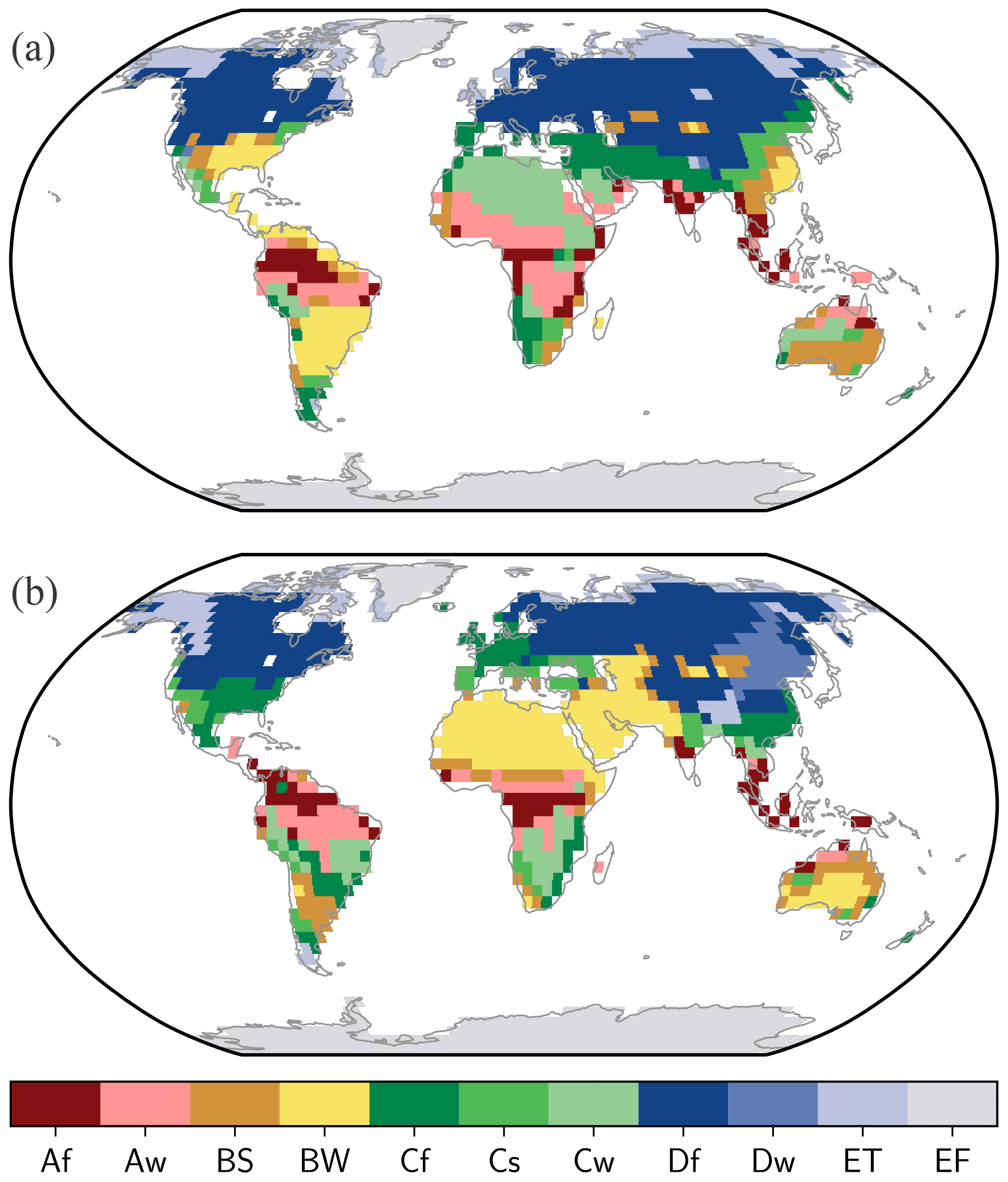
A few attempts at doing a speculative map for a world that spins backwards have been done on the internet since a certain study by Mikolajewicz et al came out in 2018 that gave various climatic data on what might happen. I myself have been worldbuilding one for a couple years on/off. Several maps have been shown on here before or since speculating climatic conditions based loosely or speculatively on the study. Especially when it comes to more specific details that the pictures in the study itself don't provide, but the accompanying video files do. I have been one of these individuals before.

However; none of these used data directly from the study to simulate the temperatures, humidity and seasonality of such a timeline directly, mainly working off guesstimates. With permission from Mikolajewicz himself, I managed to download climate data used in the study and collaborated with the owner of the WorldbuildingPasta blog, who specialises in speculative climate maps of alternate and alien worlds, and he managed to run the data through his software in much more detail than was previously available, creating the map and key shown above.

In other words, this is by far the most accurate climate map to the study that has been made so far, as it was created directly from using the study's data, although it isn't perfect, as there appear to be slight differences between the definitions and criteria of biomes between the study and the blog's software.

Still, this appears as far as we can tell to be the most detailed take on a Backward Spinning Earth so far. Note the substantial changes in the size and distribution of certain habitats, such as the reduction of deserts and dense rainforests, while Dsx climates, very rare in our timeline, are pretty common here.

Otl postindustrial for comparison;
 
That's honestly incredible. Both in the level of detail and in the amount of effort that you've put into this.

I've genuinely never seen an alt-climate TL that was so deeply thought out. Keep going!
Ah thank you, the compliments are appreciated! I just wanted to be as thorough with my research as reasonably possible to ensure that it's done accurately and see exactly how and why it differs from our world and what implications that has, hence why the political and biological framework of this world have changed.
 
The Yellow Age
]The Rise of a New order.

"In the span of a few centuries, the west and the east ushered in a golden age where the Mediterranean usurped the near and Far East as the great power for the first time" Jibou Bijunsi, 'A Hierarchy of Time, 1066 AF [1824CE]

An Age of the Greats.

Three thousand years before the present, the world's great nation building regions began to truly establish themselves and from them came the first empires, powerful and typically multiethnic states whose power could project well beyond their typical borders. Whether it be the pyramids of the Mississippi or Yangtze, the plains farmers of the Nile or the city states of the many Great Lakes, this world's great fertility but relative isolation allowed greater nation states to emerge quite independently of one another. The west, the east and the Far East all gravitated towards states of some form or another, whether merchant republics or massive sprawling empires. We shall look at some of these as they rose to prominence.

The Far West

In the Lands of the Rising Sun, the Mississippi River's many peoples traded and grew rich off one another. Republics began to form out of democratic tribal confederacies in the northern Mediterranean habitats, able to deal many resources and sell commodities to the peoples of the desert in the south. With a complex river network and a variety of different habitats, the Mississippi had become the lifeblood of this North America east of the great mountains, and seperate from the stormy subtropical southwest. The peoples near the base in the Great Lakes [4-8C warmer and somewhat drier than otl, think our Virginia or North Carolina] were formed a large confederacy known as the Byanalam peoples. Instead of hereditary rulership, direct Democratic elections were encouraged among local urban and rural settlements, and as more settled in cities such as Vina and Lamadan, mercantile republics began to form for the first time in the world's history. Lamadan in particular broke off from the other Byanalam people groups to form its own identity and state, extending influence across the land, extending into the east. Across the northeastern region of Hinunaway [OTL New England and the Maritime Provinces with a Mediterranean climate], another large tribal confederation arose, with the warm and dry land proving very suitable for growing expensive crops but lush enough to not be surrounded by deserts like those of Dixie. Uniquely to the northern continent, not only were Homo sapiens as we know present here, but substantial quantities of the otherwise elusive Homo appalachius, the descendants of wayward Homo erectus that made their way to the Americas before and likely inoculated the fauna of the land for human hunters, meaning the extinctions upon sapiens' arrival were not as bad as they could have been. Breeding between the peoples was common, and despite diverging genetically more than 1.5 million years ago, considerably further back than humans and Neanderthals, fertile offspring were still viable. As a result, Appalachian and half-Appalachian nut farmers and merchants, selling bear and sloth pelts, made their way further south into the plains where the steppe nomads continued to raid settled societies, and even beyond that into the deserts of the Deep South.

The people living in the mouth of the Mississippi [otl New Orleans, now over 10C hotter than otl and much drier], now known as the Shanayuma, built a flourishing set of cities around the mouth, an island of green in one of the worlds largest deserts. The Shanayuma, already well established for some time, built in the 8th century BCE a proper empire for the first time in a state known as Shahartan. With mighty Ziggurats over 50 metres tall being built by the ruling Shifuday family, in honour of their gods and their status as providers for their people surrounded by a harsh landscape, the southern edge of North America was a flourishing place of commerce, not just with the city states and tribal confederacies of the plains and forests further north, but along the coasts as well. The Shifuday were also having their fair share of militarism, conquering other cities in the northern Mississippi and around the southern coast with the help of mobile cavalry as well as tamed desert-mammoths (Mammuthus alamus) Around the early 6th century BCE, the Shifuday were overthrown in a civil war by the nomadic Namarash tribe, whose titular leaders soon cemented themselves as a new ruling dynasty. Contact with the peoples of Tuja [Texas, even hotter and drier than otl] in the west and the Naka people of the Yucatan peninsula [more grass and scrub than jungle] was easy to make for the new rulers, and so trade between them was frequent, but an even stranger set of lands existed further east in the Caribbean.

Cooler and significantly drier than they had been before the reversal, the Caribbean islands and the hook-shaped peninsula to their north were isolated from both the ziggurat building civilization of the west and the moderately warm east coast to the north. Thus, a network of island based peoples using boats to communicate with one another over long distances developed. Known by many names, one of the most common names for this loose grouping is the Lipauwai, though in reality they were certainly many different groups. Without the harsh storms that isolated the islands before the reversal, travel was relatively easier and so an interconnected society was involved, even settling on the mainland in places such as along the north Venezuelan coasts, or the Attan valley [north-east Mexico]. There are even theories that some sailed up the Mississippi and founded the very distinct Kikinu culture of 1st Millenium BCE Tennessee. In [756-690 BCE], the Kiniku launched multiple attempts to invade Shahartan from the north.

On the stormy but wet west coast, a different order assembled itself and the first of a few great empires rose. Starting around the early 9th century BCE, the Kalifo tribe settled in the south of the Kalifona lands [guess what this is], a prosperous land with fertile vegetation and a swampy environment suitable for aquatic game and some large animals to dwell. The Kalifo expanded significantly against their neighbours by taming one of the most formidable animals of the region, the Sarahor [Mammut sp.], a distant relative of elephants and mammoths found in the lusher west coast. With long tusks, short legs and a much bulkier build than elephants, the sarahor made fantastic beasts of burden to move heavy objects or carry multiple soldiers on a tower. For logistics or for war against rival tribes in the region, the Kalifo made good use of them and formed a good sized empire using them, but ran into the mammoth [Mammuthus columbi] riding peoples of Atlahan [north-central Mexico, warmer and drier than otl resulting in a Mediterranean climate], who put up a stubborn resistance and prevented them from taking over more southern territory. The dry and deserted regions of Central America proved a difficult barrier to get to as well, and at this time only a few minor nations existed in the Andes, so we shall leave them for another time.

The Rise of the North Coast

The Sahara, home to many peoples managed to birth a range of nomadic peoples of the Niger plains, as well as great cities around the rivers, the coasts and the huge lakes of Chad, Taurus [located in southernmost Algeria] and Vi [southern Tunisia], was likely always going to breed powers powerful enough to rival Khemros, and the Azra to the east; the former hardened by attacks successful and otherwise by the Zabidae nomads of Zabid [Darfur] and the latter grown fat and rich through trade across the Indian Ocean. What was not anticipated however was the rise of a city out of the relatively cold northwest, with its snowy winters and milder summers. The city of Krassuc expanded outward at the start of the first millennium BCE and began to move beyond the Tunis region. Fast. Swift campaigns allowed it to expand all the way west to the Straits, finally conquering the despised Brazmayids, and sacked their capital. After this, further expansion was relatively easy until they reached the swampy city of Jhomonfo in the late 8th century BCE. Here, they faced one of their first real opponents in Senegal, the Cahaun Confederation, a successor state of Zana. Further north, they also faced a rival in terms of the Silian [Sicily and southern Naples] republic, with allies in southern Huspanaa [Iberia]. Around the late 8th and early 7th centuries BCE, Krassuc expanded significantly northward, resulting in multiple wars chipping away at these lands before they were annexed, then expanding into the entirety of Huspanaa and even beyond. The Huspanaa and Brazmayid cities of Rusna and Bruzmii merged into a larger and vital trading city known as Bramovi [OTL Gibraltar, but over 6C colder and wetter, with a climate more like our Brittany or Nice but a bit wetter], which in time would become a thriving metropolis that would rival or even surpass Krassuc. At the height of its power, Krassuc's power stretched from the westernmost point of Africa to the Anatolian peninsula, and from the Pyrenees in the north to Mauritania in the south. But this was not to last.

The second golden age of Khemros began in the late 10th century BCE, with the grass and Savannah kingdom launching expeditions against the northern Zhabida and expanding into the grasslands, using these to build grain. A period of relative peace in Skidoosh to the south allowed Khemros to focus its efforts against the Euphratians and Arabs for dominance. Zyprios, long a tributary state, was finally annexed on 880 BCE, and soon afterwards, the Harrader dynasty expanded north of the Golan Heights on the mainland, all the way up to the local city state of Xan [Cicilia], who remained a stubborn thorn in Khemros power in the region due to rebellions. Not just militarily, but Khemros did well economically and culturally in this era, exporting its culture to the Horseshoe coasts [otl Libya]. This age did not last forever, and the golden kingdom found itself a victim of Krassuc's Great Eastern War in 783 BCE, conquering all the way up to Xan as Khemros had. Overextended, however, the Krassucans struggled in their attempts to conquer the neighbouring Euphratians, a horribly timed campaign due to the unification of the Ugrala or 'Peoples of the Plataeu' [equivalent to Iran, much cooler, wetter and greener than otl] by the campaigns of Urga the Great, whose Silvertongue legions and great cavalry swept through the Fertile Crescent and briefly seized Khemros from Krassuc's control in a humiliating peace treaty in 568BCE. Urga's campaigns lasted from his late teens into the end of his 30s, but when his death came in 542BCE aged 43, his sons were not responsible and they quickly fell into infighting, as the internal divisions he gave to them became the formation of new countries. The unification of the Ugrala plateau, however, was a long term effect of this. During this collapse, the Nubian kingdom of Skidoosh 'liberated' Khemros from foreign rule, setting up an allied regime to stabilise the region from Ugran successor states. While in theory, they are equals as north-east African bulwarks against the grassland dwelling nomads in the west and the Arabs and Ugrans in the east, Skidoosh was clearly the main player in this alliance.

Another rival the Krassucans had that was more pressing was on the west African coast, the Cahaun. Centralising into a more powerful nation dominating a significant portion of Africa's west coast, Cahaun was a quite different beast to its northern neighbour. Instead of ruling over a diverse empire of peoples but unifying them under Krassuc's direct imperialism, the Cahaun had a more loose hand in the cultures they ruled over, which proved advantageous for ruling and inspired less resentment in local peoples. They could thus spend more resources expanding southward toward the South-Atlantic coast, and planning a large campaign to take the Serer lands from the weakening Krassuc Empire. However, this extension of themselves as well as their lack of a central Cahaun identity meant their empire of sorts was not going to have as much of a long term cultural impact as Krassuc.

The Ugrans didn't limit themselves to the plateau and the lands of the northern Nibetay and Khemros, but also pushed northwest into Anatolia, a mountainous land of plenty, with much agrarian land to make use of. The smaller cities and kingdoms of the region easily fell to Ugra the Great's forces, having never lost a single battle throughout his campaigns. In the aftermath of the campaign, new large roads were built to connect them further east, which remained after the empire's collapse. A significant state arrived in Transcausia [otl Greater Armenia], even as a vassal of the Ossomari empire, founded by a nephew of Ugra, ruling out of Duzna [otl Ninevah], extending influence into eastern Anatolia. Where previously over two dozen smaller states and a number of petty tribes existed, Anatolia and the other side on the Balkans became no more than nine, though one fell to the Krassuc legions in 512BCE, the limit of Krassuc's new north-eastern domains. Krassuc also took Sicily and parts of southern Italy, vassalising the Remulan Heptarchy of central Italy [substantially cooler than our own, more like New England or Poland] though going no further north. Beyond the frigid and snowy Alps lay a newly developing confederation of tribes, known as the Helvugans, who wished to migrate from the cold and hostile European mainland [more like otl Siberia] towards more appealing and fertile lands around the coasts. In the coming centuries, they and their related tribes would get this chance.

The World's Largest Lake

The Indian Ocean, with a strong monsoon in the west, rainforests in the east and the various islands of the further east, into Uz, was bound to be a powerful zone for merchants. With a zone of fertility stretching from the Vibuay lands [Tanzania] all the way to Burma, and another in the islands of Indonesia and western Uz, the population of the ocean's peripheries was extremely dense, and developed a flourishing economy as a result. Some of those making use were veterans, but others were newer to the scene.

The Azra of monsoonal Oman participated in an enormous network across the known world, and so forged new opportunities as they went. Establishing trading outposts as Far East as the islands of the Sunset kingdoms [like Indonesia, the Philippines and even Taiwan], their main zone of influence was competing with Atum for the lucrative trading opportunities in the Horn and in the lands beyond, along the green and rich eastern coast of Africa. Controlling vital supplies of resources, pelts, exotic animals and fruits, seeds from plants not found anywhere else in the known world, and tales of strange islands even further south, inspiring further travellers to explore the coasts of Africa. It was during the 7th century BCE that the Ghishundai [Dubain] scholar Al-Ghasar Zamad launched the first circumnavigation of the African continent, all from his original post and even carrying his boat through pillows across the Sinai peninsula, with permission from the then-ruling Krassucs.

Through the Red Sea, the Nibetai of western Arabia were the first to go through the goods exported from Khemros' east coast, and so they built a large empire expanding into the interior. Competing with the Euphratians in the Persian gulf, the Nibetai strategically needed to secure the tropical gulf of Aden from the Omani Azra. The dense jungles of [Aden] were not too dense for decent human habitation, but farming could be difficult except for rice due to the sheer rainfall density.

The dominance of Arabs would soon be called into question, however by the previously divided peoples of the Iranian plateau. Ugra's armies marched beyond the initial Euphratia into the tropical heartlands and grasslands of Arabia, even reaching the mountainous west. The eastern lowlands, forest and plains alike fell quite easily to the organised legions of the upstart king. Nibetay resisted fiercely, but soon it too fell to the rule of Ugra the Great. For more than a decade, plateau culture intermixed with that of the euphratic and Nibetayan Arabs alike, and with one another, but with the partition of Ugra's empire between his sons, the different kingdoms' unity lasted only briefly. Too busy conquering to spend as much time with his sons on settling existing disputes and developing good rulership, many of his sons simply didn't adapt well to rule, and his fourth son Ugalon was easily overthrown by the Nibetayan people in 518 BCE, restoring native rule.

The Kharmaneids were easily the most powerful successor state to the Ugran empire, and maintained dominion over the Iranian plateau after their collapse. Building a legacy as the main successor of a mighty empire, this kingdom has by far the most manpower and grain of all of the successor states. With rich valleys fed by ice-capped mountains and the resulting rivers, the plateau they own is a thriving land of many cities, and so the people of this land are well fed and diverse. Even the south-east of the country is not a large desert but a flat forested land, full of tigers, buffalo and hairy-men. While the largest of the states, it also has a solid trade network with other lands, and is competitive with its naval trade rival of Tigra, a realm dominating the mouths of the Euphrates and Tigris rivers [covering otl Kuwait, Khuzestan, southern Iraq and Bahrain and Qatar]. Tigra may not be nearly as large as Kharmanei or Ossomari, but its lucrative position and ownership of the river delta allows it to have a substantially large population for its size, including some of the largest cities in the Middle East such as Tigfa [Kuwait]. Multiple attempts of conquest have been made by the Kharmaneids at this point against their neighbour but each has been repelled, for they use the same tactics against them.

Northern India during the first half of [the last millennium BCE] did well in this time, mainly being divided into a number of small kingdoms but soon converging into a couple of large and powerful nations. One of these was Thunda, a land of former tribes in the woodlands of the Thar valley, originated in the 880s BCe and remaining minor for centuries. However, in the late 7th and early 6th centuries, they divided and conquered their neighbours in Thar, and avoiding conquest by Ugra, waited until his sons' regime fell apart to nab the border regions of the Indus valley and form a true empire. This way they could compete with their main rival east, the Yadaprit Principality, forming out of the central region of northern India. Thunda and Yadaprit had quite different methods of ruling over their peoples, with the latter certainly being more decentralised than the former. Other kingdoms across the indian subcontinent did quite differently, as the land is much wetter than in our timeline. The southern tip of India was not home to a major civilisation like our own, but instead one of the world's largest rainforests, home to a wide range of plants and animals, particularly monkeys, dwarf elephants, apes and lizards. A unique form of panther exists here, known as the Ceylon Panther [Panthera indicus], a robust creature convergent with the south american jaguar, believed to be a reduced relative of the tiger adapted to hunting in dense forest environments.

The Far East

The age of Dharnamese supremacy lasted a long while in the Sunset Kingdoms, and indeed that pyramid-building civilisation continued to do well, but north around the yellow river, a rival began to stir, for as with Ugra, the divided kingdoms of that land finally united under common rule. Out of old kingdoms like Wei, Jibon and the like came a new state known as the Yuga, who led by the Yuganoi clan, overthrew the old order, considering the divided kingdoms of the Yellow River as weak and impotent, hoping to replace them with a true power. At this they succeeded. Yuga at its base of the mouth of the Yellow River quickly expanded westward and northward down the river, reaching far into the Gobi Valley. Becoming perhaps the most powerful nation in the Far East, Yuga managed to surpass even Dharnam as a source of influence and culture.

In Dharnam itself, the power of this coastal civilisation continued to grow and thrive against the odds. The rivalry with Yuhan withdrew in later eras, as the regimes became generally more peaceful as a result of minor climate change and increased trade with the now united northern realms. The desert proved too large a barrier for the new Yuga empire to wish to cross, preferring a more indirect relationship with the jewel of the Yangtze. As a result of this, the sun-worshipping kingdom flourished for a time, though internal strife continued with droughts in the 7th and early 6th centuries BCE. Around 577 BCE, the ruling Haj-Muhud dynasty ended up being overthrown by a rogue Yuhanese army, from a defective general who rode up the Yangtze and took them over in a time of drought and civil war, as the Haj-Mahud family was engaged in a bitter civil war between brothers at the time. The Yuhanese general, Cong-King, soon purged both sides of the conflict and crowned himself as king of Dharnam, forming the Coganami dynasty. With increased rivalry with Yuhan as a result of their old rivalries, the period from 570-520BCE was a period of near constant warfare between the two. This decline in recent years allowed them to be eclipsed by the ever growing Yuga to the north, but after the warring period was over, Cong-King's grandson Cong-Kuga enacted a variety of reforms that gave more rights to the average citizen and allowed one of the world's first parliaments, forming a constitutional monarchy somewhat like that of Krassuc in north-Africa, though under a quite different circumstance.

Dharnam's reformations were certainly of importance, but another order grew even further north than their rivals around the Yellow River. The islands of the Ymoshee and Dyunshee [Japan but much warmer, especially in the north relative to otl, more like Italy] began to organise into centralised states. The two very distinct cultures developed in tandem with one another, and remained firm rivals, with the Ymoshee containing a number of crossing over with the peoples of northern Manchuria and the Sakelyin peninsula, such as the Ulki civilisation and the even further north Kohost, a tribal confederation found across the Okhost sea [think otl Baltic] that would sometimes trade or raid the Dongvai to the south. The Dyunshee were an extension of the Shonigima peoples from the Korean peninsula, albeit with a distinct island form, while the Ymoshee were the native peoples of the islands, initially driven to the north until the Ymosh republic formed and began to drive them further and further south. It seems only a matter of time before the Ymoshee manage to drive them completely off the islands. The peoples of the first Ymosh republic were monotheistic, worshipping a bear-headed god known as Umuri, who commanded his followers to respect nature and revere bears, with the followers of this religion carving bears into their mighty temples. It seems as Yuga grows, this nation may be another great rival to Yuga in the future, though first it would have to deal with the other relatives of the Dyunshee.

The other most powerful of the states north of the Shonigima [Korea] states was the Trapeng dynasty of Bukan [Primorsky and Vladivostok], who managed to expand across much of the Far Eastern land up to the river Amur [which has a similar climate to otls Seine river], and influencing beyond to the tribes of Ulki in Sakeylin, competing with Ymosh for influence there. The Ulki had formed an urban society in the form of Tutar, a city right in the centre of the straight between the peninsula and mainland [Manchuria], but for reasons unknown to us, that regime collapsed and its ruins remain to this day. Trapeng's growth put them at odds with the power of the Dongvai Republic, another Manchurian nation that spread further west into eastern Mongolia, threatening the isolationist city of Ping on the shores of Baikal. Dongvai was situated in northern Manchuria [think otl Beijing, Shanxi or Germany for climate] and as a republic, was under a single ruler elected for life [somewhat like otl Venice], who would decide policites on trade, war, politics and even religion. Dongvai had successfully resisted conquest by Yuga in 611, 588 and 531 [BCE] through good infantry and the building of a great border wall to keep the Empire from bringing them down. All the focus on their western neighbour, however, has left them more vulnerable to the ever expanding Trapeng.

On the other extreme of the great Nanman desert lie a few minor nations in south-east Asia. Much hotter and drier than in the timeline that you know, these lands are rich in natural resources but economically poor, and this was the case back in classical times as well. Around the early 8th century BCE, most of Indochina was united under the Tejarka empire, which came originally from eastern India, but this has since collapsed and the successor states intermixed with local peoples. The grassland kingdom of Arram in the north was naturally the much larger of the two, but its southern neighbour Dhiva had a higher population and more forested landscape. Worship of the speckled hairy-men (Paranthropus indochinensis), now increasingly rare in this land, declined from previous eras in favour of the ancestor worship more typical of the land's native inhabitants. The isolated kingdom of Honunu was near these states as well, lying right on the edge of the great desert of southern China. Trading with its western neighbours and not much else, the nation built up large walls to protect from desert dwelling nomads who wanted to raid its borders, as they would over time.

There are many different ways in which this timeline may change in the future, but the state of the world as of 499 BCE can be seen below. Our next look into Reversia will take a break from human history and look at the more biological side of it.
 
Uninhabited islands as of 0CE

"The last bastions of nature separate from the influence of men, whatever their form, the islands of the world are a snapshot of what had been without us."
Yaromiv Zurpan, [1908 CE].


As of what would be the start of the common era in our timeline, there were still many islands free of human influence. This is also the case with Reversia, despite a greener world lacking some great boundaries like the Sahara or Middle Eastern deserts. Places like New Zealand, Hawaii, the Galapagos and the north-Atlantic islands remain flourishing ecosystems without man's influence, and the different climates of these lands allow them different luxuries to what they had in our timeline.

Aetoria (New Zealand):

Aetoria is not wildly different to the one we know. Somewhat cooler than our own, and a bit drier in the north, this isolated land is home to a range of strange birds, with the only land mammals being bats, including semi-terrestrial forms. Moa such as the mighty Dinornis tower over the competition as high browsers, equivalent to the giraffes of Africa, while smaller genera browse at lower levels, coexisting by feeding in different leaves and fruit. Very unusual birds, the moas are not related to the other flightless birds of New Zealand, but are more so to the tinamous of South America, a group that themselves have declined and moved westward due to the consequences of the Reversal. Moas, in contrast, haven't had nearly as severe issues with the climatic changes as south america, even if disturbed wind and storm patterns have undoubtedly changed their lifestyles and the direction from which new birds immigrate to the islands. Despite their size and diversity, they are not free of predators, for the adzebill birds have grown in strength in the northern island. The cooler and drier climate has allowed forests to spread out more, meaning more room for these predatory birds to move around and stalk their prey, moving up from chicks to juvenile moas. They are now serious rivals to the large eagles of the islands in their hunting abilities and ruthless determination to get chicks. The largest of the adzebills is the Phobornis, growing about 1.5 metres in height due to rapid evolution in the absence of competitors. The closest thing modern humans would have to face to terror birds, Phobornis' rule over the island would not last forever when humans would eventually reach the islands from the west. The same can be said for many small flightless birds, skin to rodents and shrews.

In addition to large and charismatic birds, a number of small and at times basal reptiles and amphibians are found in Aetoria, such as the last of the sphenacodontians and multiple species of gecko. Most peculiar though is the Spiny Tortoise; a dwarf form of the Pleistocene Australian fauna Meiolania, whose arrival to Aetoria is a mystery. The most common theory is that this derived lineage drifted eastward from Australia due to the reversed wind and rain currents sending some ashore. Too large to be threatened by adzebills and low browsing to avoid competition with the moas, these formidable armoured beasts have less extreme armour than their continental ancestors due to a lack of sufficient predation, but enough to protect it from any native predators in the region. In the leaf litter, various insects found nowhere else also roam here in unquantifiable numbers. With the changes not as drastic as with other parts of the world, the native fauna of New Zealand didn't take too much, merely taking the changes in their stride.

Hawaii:

With more extreme differences in climate relative to New Zealand (though certainly not as extreme as the desertification of the Philippines or Madagascar), the Hawaiian islands became an even more profound hotspot of biodiversity than they had been before. Becoming 2-4 degrees Celsius warmer in annual average and consistently rainier than before, with the rains and winds flowing from the east rather than west, the new colonisers to the islands came from different directions, and the land they arrived at was greener than it was before the Reversal. With a longer distance to go than from North America, the organisms that arrived to the islands tended to be more of a mix of asian and north american fauna and flora. As the older islands eroded and new ones arrived, the more ancient fauna were forced to migrate eastward or die out, while competing with new arrivals.

Far and isolated from the mainland, there are no land mammals, reptiles, amphibians or ants on these islands, except for a few species of bat of Indonesian descent. Thus these islands are land of the birds, even more than New Zealand. A variety of tropical birds from Indonesia and the tropics have come over, as well as birds from the drying out China, as the latter's desertification caused many to flee the region and some immigrated all the way out to Hawaii by chance. Hence, on the more western and middle islands, there are a strange group of lanky birds known as Mua-Nua, adapted to a browsing lifestyle at a higher level than the Moa-Nalo ducks, using long necks and small heads to browse, like ratites. But these are not ducks or even geese, they are descended from doves migrating eastward from an increasingly dry China. With an absence of competition, especially on the Big Island as it formed, they proliferated into a diversity of forms. Mua-Nua live alongside various honeycreeper birds feeding off nectar and insects of many forms, themselves substantially different in the absence of predators, with there being flightless varieties of moth, butterfly, cricket, beetle and even, most bizarrely, flies. Some of them are giants here. For example, the Flycrane (guess which group this is) grows over 10cm long, and is arboreal, blending in with twigs to hide from predators having evolved convergently to the stick insects of other lands. Hunting them is a strange form of bat known as a nightstalker, a particularly aggressive variety of bat adapted to an unusually terrestrial degree. While still capable of flight, the enlarged insects (due to slightly higher oxygen levels thanks to cyanobacterial blooms in the Indian Ocean) have provided this particular bat with a decent food source. Using strong jaws and teeth to dispatch prey, they have also moved on to attack other bat species and even the chicks of some birds. Another species is the false-vampire, convergently evolved with their South American namesake toward parasitism.

Despite a lack of competition, the islands are not entirely free of predators. Descended mainly from immigrants from East Asia, owls are the top predators of this strange ecosystem. Stilt-legged forms prey on both the ducks and the doves, pinning prey down with long and powerful legs and eating them alive, piecemeal. Many species coexist by feasting on different prey, ranging from small arboreal species still capable of flight to large flightless forms that have even been known to attack adult Mua-Nua. The smallest species of stilt owl, known as Tuagi, feast on small mice and chicks of other birds, including the largest species; the four foot tall Deinonyx. They would remain apex predators here until the arrival of humans, Homo novus, from an unexpected source.


The Galapagos

The Galápagos Islands, or as this timeline's native Peruvians the 'Xitino' call 'Hunyuho' (meaning far west in their tongue), were the birthplace of the theory of evolution in your own timeline, but in the Retrograde Earth, they are of a different sort. As with Hawaii, they are warmer and wetter than before, but to a greater extreme (4-6 warmer and with humidity more like our northern Madagascar) as well as slightly larger due to the lower sea levels. As a result, these islands retain Darwin's fascinations in action.

The lush tropical rainforests mainly of daisy descendants here create room fora substantial array of fauna. Lizards of various forms dwell in the trees as well as on the ground, filling a range of ecological niches. Avoiding competition with the iconic tortoises of the islands are iguanas, feeding on low living vegetation, usually camouflage to avoid some of the predatory birds that dwell here. Aquatic forms in both freshwater and the sea exist, feasting on underwater weeds, algae and other aquatic vegetation. Though varanids are not present here, some of the smaller lizards to make it here from the east have grown in size to prey on small rodents and other lizards. Hawks migrating from the mainland have also adapted to exploit these different lizards, with some specialising in different prey like iguanas or tortoises. For example, the Serpent's Bane is a specialist in feeding on the so-called harmless snakes of the island, for there are no venomous snakes on this land. A variety of seabirds and even penguins were present in the islands long before the Reversal, and they are here afterward in even greater quantities due to the larger island sizes after a sea level decline. Additionally, just as with New Zealand, one of the penguin species has adapted to the freshwater conditions to feed on fish upstream, known as the Little Skipper. Possessing a single white stripe along its brown feathers, they have adapted to better camouflage from predators in the daisy forests of Galapagos. They are named for their waddling posture adapted to longer legs for a more terrestrial lifestyle, resembling a skipping motion. It helps them escape from terrestrial predators such as the aforementioned hawks dwelling here. They may even fall victim to a much stranger threat, that being the death-head finches. These predatory finches have adapted to the great increase of insect and terrestrial prey by adapting to a lifestyle not found among the hawks here, being swarming predators that can overwhelm and eat prey alive, including penguins. Alone, death-heads are content to eat insects or drink the blood of much larger birds, but can be whipped into a frenzy in large numbers and can drive even the largest hawks off their kills with sheer ferocity.

Of course, it would be impossible to speak of these islands without their namesake, the tortoises. With hot and humid conditions, these strange reptiles flourish on vegetation, as do turtles in the waters. Each island has some variety or another of tortoise, as do different habitats such as monsoonal forests, open woodland, the rare savannahs and grasslands and alpine meadows [the most similar to otl, though still warmer and slightly wetter]. Too large to be bothered by birds of prey as adults, the tortoises gather in groups to protect juveniles from the more abundant predators. Impossible to class as either a single species or several, they are best thought as a complex; a spectrum of local variations of genes that can interbreed with one another, some more easily than others, and may prefer different habitats as well as islands. With lush monsoonal forests to call their home, they have become the largest tortoises alive today, dwarfed only by the extinct Megalochelys of India. Their booming calls are a common sound on these islands, and just as in our own timeline, it is small wonder how the islands came to have their name.


Reptiles and birds are not the only things on these islands, however. With receptive currents and slightly lower sea levels, travel to the island by mammals is therefore possible. Not only with Pacific seals thriving around the coasts, but with more recent arrivals from the mainland. One of which is the Galapagos ground sloth, a dwarf form of Glossotherium. With competent swimming abilities and lush vegetation available to them, these sloths quickly adapted to life on smaller islands and dwarfed from their mainland form, though are still larger than any of the tree dwelling sloths of the Amazon (especially after the Reversal reduced its size). Feeding primarily on low laying leaves out of reach from the tortoises, they rear up on their hind legs to acquire food, a trait the reptiles lack the ability to do. Unusual among sloths, they are a black colour with a white stripe down the body to help camouflage in the monsoonal forests. Compared to their mainland relatives, they have proportionally shorter hind legs and a greater slope in their back, making them convergent with the extinct ungulates known as Chalicotheres. Weighing up to 150kg, they are a far cry from the giants of the mainland before their extinction or retreat into the deep Amazon or Patagonia, but nevertheless are a strange and beautiful creature to behold.

Other mammals that dwell here consist of a variety of unique mice and bats, many found nowhere else on earth. Among these various small creatures exists some island giants. Islands are known for changing the size and shape of the animals that live there. Large animals come to the islands and shrink due to limited resources, while small animals grow and morph in shape due to a lack of competition. The slothmouse is convergent with the mainland Xenarthrans in a sense, being a fruit eating murid thriving in the trees. Having a much higher metabolism than sloths, they are still quite quick to escape from predators of land or air, and thus only reach the size of a muskrat compared to others. Still, their teeth are sharpened to help pierce the soft fruit, while molars grind the seeds to a more manageable form for digestion. The small seeds of plants pass through the digestive system and out to fertile new soil. Thus, the slothmouse is an important part of the Galapagos forests' ecology.

Along with these uninhabited islands, there are a number of small and very remote islands, though most are far smaller and thus hardly worthy of note. The other islands of the world, the Seychelles, Madagascar, Mauritius and the many of Indonesia have already long since been colonised by humans before the year [1CE], and while we could talk about the fascinating desert lemurs or fossa's of that island, their spread across the Indian Ocean thanks to Jamareet traders have taken these hardy primates well outside their normal zones of occupation, as far as the fringes of Nanman!

We shall explore the alternate biology of the retrograde earth in future as part of our exploration of this world's cultures and civilisations, particularly how some are utilised in unique and alien ways.
 
Mediterranean in the Dark Age
"In a new age where power was not solidified by a single great empire, competition helped drive the first major wave of innovation, the effects of which are still felt to this day." Danar Rigip, in her work 'The Dawn of Etnos'.


After the fall of Krassuc to the zebra riding barbarians of the south around [104 CE], there was a great power vacuum in the Mediterranean basin. Destined to be a great zone of trade and fishing due to its geography and climate, the region's base of power fragmented. In the west, the port city of Bramovi, now renamed to Rhogosh [a local word for 'centre of the world''] rose to even greater prominence, becoming known as the "City on the Rock'' by many due to the main palace being located on the top of the island in the straits, a stepping stone between Europe and Africa. The city was wet and well watered, and with a variable seasonal climate (cooler on average than OTL Venice or Bordeaux in fact), with fertile lands on either side of the strait to extract resources from. Already a powerful trading city under Krassuc, Rhogosh grew further under its own independence, expanding northward all the way to the Pyrenees as well as eastwards to Lake Ghal [located in northwest Algeria]. Rhogosh was less of an empire and more of a republic under the old majors appointed by the Krassuc emperors. First and foremost, a formidable fleet was necessary to protect the Rock from invaders and pirates, and soon great walls were built on either side of the city of two continents. Traders from far and wide came to the city, with Khemro cottons meeting Anatolian silks and Baltic furs. Rhogosh in the 3rd century CE was a prosperous land, weathering the collapse relatively well compared to its neighbours who took much longer to recover.

Eastward, Krassuc's old carcass was picked at by the resurgent islanders from the north [i.e. Sicily and Sardinia], who drove the Niger nomads out around 160 CE and set up their own shop there. The Zici 'high kingdom' as it came to be known, was really an alliance of Italian kings ruling over the core Krassuc lands [Tunisia and Tripolitania] and the southern two thirds of the Italian peninsula, though the north remained under the brief Helvetic tribal confederation. Through the invasions of the North African coastlines, the Zici peoples found a strange domesticated creature quite unlike the cats used to catch rodents across other parts of the known world. Colubrid snakes, common across the green Sahara, became welcomed into the homes of many Maghrebi peoples as a way to catch rodents, the hot and humid conditions being very suitable for them. In time, these snakes became fearless around humans, and gave rise to a new domesticated breed known in Krassuc as the Zerps [Krassuci for 'slithering friends']. One of the Zici kings, Hanu of Fidri [divided between southeast Naples and western Libya], even attempted to crown himself king of Khemros in the east, though this proved disastrous. The Sicilian raider-kings had never before encountered the fierce elephants of Africa in battle, as none were available when they attacked an already sacked Krassuc from the southern nomads. The great four metre tall beasts with tusks as long as they were tall carried towers full of archers on their backs and wore studded boots they could kick any unfortunate Italian a good distance. Hanu stay put in the southern peninsula and former Krassuc homeland, instead consolidating his regime and dominance over the other Zici states.

The elephants of the Mediterranean and Middle East are genetically a complicated matter. Without the great banners of the Sahara desert or the Middle Eastern desert complex, intermixing between different fauna from Africa and Eurasia became much easier than before, despite the great distances. Subtropical and tropical habitats stretched uninterrupted from the Cape to Sumatra, and even further when factoring in the more open "Mediterranean" climate going all the way to the Yellow Sea. Thus, the elephants of North Africa and the Levant contain a genetic mix of Loxodonta and Palaeoloxodon genes, more the former in most cases, though interbreeding with the latter has occurred due to trade with the Ugrans of the Iranian Plateau, where these larger dome headed elephants flourished. Additionally, Elephas could also migrate westward into these regions, though had far more difficulty interbreeding with other elephants and remained much more distinct. With elephants more diverse and widespread than even before, the spread of humanity did not impact them as severely as in the prograde timeline, and so it was only a matter of time before humans utilised them too. Intelligent and fierce, they struck terror into men from across the world. Elephants were also used in the armies of Hind, and even in the America's, though of a different kind. Another population still was isolated in northeast Asia, though that is a story for a different time…

Around the 142 CE, the vassalised Khemros regime broke free of its southern overlords of Skidoosh and reasserted itself in Egypt, Cyrenaica and the Levant, setting itself up as a rival to the Vanoans, a newly settled nomadic tribe from the steppes of Central Asia that settled in and conquered the various petty kingdoms of Anatolia and northern Syria. The Vanoan king, Yeninoman III, controlled the Bosphorus Straits, a strategically important strait nearly as useful as Rhogosh, and they possessed an impressive fleet too. Thus, despite some land overlap, the majority of fighting between the two large kingdoms was by sea. The Isles of Zypriot (Cyprus) and Funi (the native name for Crete) were also a battleground between the two powers. Multiple wars were fought from the late 100s to the mid 300s between the two, but in time, relations between the two changed for the better. Part of this was due to raids from boat-dwelling people coming from the other side of the Black Sea, a mysterious group known as the Staranites, who became a common enemy. Another was the increased prominence of iron ploughs, which allowed more efficient circulation of crops and less need for them to invade one another's land to feed their population. Additionally, trade with the Nibet Arabs and the Ugran's successors the Medikia exposed them to new philosophies, particularly the new faith of the White Flame. Similarly, the Zici's northern rivals of Mut formed an alliance with Khemros, giving the power a medium with Vanoa to trade goods. The hunger's satiation could only last so long, however…

Further south, the Great Lakes of the Sahara and their surrounding rivers entered a second golden age in later times. Cahaun in the west became increasingly unstable during the 1st and early second centuries and so could no longer resist the Zabidae raids from the centre. A power vacuum was taken by none other than the Sutukai, who conquered their fellow Chadians, pushing back the nomads of the north; and pushed southwest until they reached the sea, conquering even the Nigerian Yomo. Sutukai was now an elite power on the African continent, owning rich riverbanks to the southeast and west of Chad, while exerting influence well beyond its own borders. Duram became the capital of this mighty empire, located in the southeast coast of the Great Lake, giving them great influence in the east. A declining Skidoosh to the north also gave them an opportunity to gain more access to the rainforests of Somalia, gaining the rare pelts and trade opportunities there.

Further west, the fallen Cahaun created a sort of 'dark age' in this region, perhaps even more so than with Krassuc to the north, though a bit later. Many small kingdoms, fiefdoms and republics split up the region of west Africa, fighting over one cause or another. One such was Byu [Gambia and Senegal], a maritime power that traded with those further north such as Rhogosh and the other Mediterranean powers. This economic stability and investments from other African kings in currency made other nations far more hesitant to wage war upon them. Their southern neighbours the Mudua kingdom [Mane and Ghana], were more focussed on subjugating the Liberians to the south, while their ships allowed them to travel far and wide, through to the Sukutai empire, even going up river to trade with the Kungilese. Between there and the Chadian Sea lay some lesser kingdoms of the Sahel, which for the time being remained relatively insignificant, though their time would come.

Another old power fell during the few centuries of what the OTL people call the common era, namely the former overlords of Khemros, Skidoosh [Sudan]. While at their height they controlled a great empire stretching from Syria to the Horn of Africa, their power waned as a result of famine, disease outbreak and civil war, first allowing the Khemro to break free of their control, then the Atun in the south. After time, Skidoosh itself fell apart into multiple warlords and petty kingdoms, hoping for the day the region would unite again under a common force. A very brief but shaky unity was achieved in 295-309CE by the Teguni Emperor Narmat, but his death led to schisms between his sons and rivals for the throne, and once again the region was taken advantage of by its former subjects, as well as the growing Sukutai. Now, in the last few years of the Fourth Century, two kingdoms on the east and western sides of the Nile compete for influence, the Second Tegun kingdom in the west and the Narunga in the east, with supporters of both sides undermining the other. The war to unify Sudan began in just 398CE and would continue for years to come, even as a great threat arose far beyond their borders. To the south, their subject of Atun, considered incompetant puppets before, found itself overthrown by one of its subjects, the Leono, who even drove the Nibetay Arabs and Azrala out of much of their former range to consolidate control over the jungle trade.

With technology and infrastructure from the south improving ever more, the tribes north of the Alps became more organised and started forming larger societies as well. One of the first tribal kingdoms to organise into a larger society in the 4th century wasn't, surprisingly enough, the prosperous lands north of the Pyrenees, who remained heavily divided into western and eastern factions, besides the "Gaulish March'' of Rogosh, but instead from the Carpathian Basin, as a new kingdom known as Slon formed. Controlling a land area comparable to England, this hardy collection of people managed to unite in isolation from any other large urbanised society, and as a winter people, they grew rich from trading furs, pelts and exotic beasts with the warmer peoples of the south. Slon's transition from a tribal confederation to a larger state was not as stable as with the southern regimes. The reason for this was the lack of ability to grow a prominent crop available in the Mediterranean; rice. Rice requires humid and relatively warm conditions to prosper, which are simply not present in Pannonia, and thus the social pressure to form centralised regimes to manage large plantations wasn't either. Thus, Slon's vassals are quite autonomous compared to its southern neighbours, who remain formidable united regimes.

Even further north, there were no urbanised societies in this early Europe, due to the colder weather and more extreme seasons making permanent settlement more difficult. Nevertheless, these lands were not monolithic and were divided into a number of different cultures and groupings. Bear worshipping tribes thrived in Central Europe, while horn-headed raiders roamed across the shores of the North Sea and Baltic. At the frontiers of Europe, near the glaciers of Lapland, the Snow People lived off the sea and scarce herbs on land as they did for millennia before. The closest of the time's tribes to what is classically called 'civilisation' were the Oriniue of Gaul, who grew rich off trade with Rhogosh, and having a more moderate climate than the rest of Northern Europe. The Orinois would also sometimes exert influence as far as southern England and the Rhine, though their influence would fade after some time. At the end of the fourth century, they finally begs to unify in the process toward a coherent realm instead of a mere confederation. Further east between Slon and Orinioid lay the many tribes and contemporary alliances of the mountains of the Urals and even beyond.

As another century dawned and in the vacuum of the retreating Helvetic tribes, a particularly prevalent Italian king, Xaron I, hailing from the cooler lands of Betun [otl Modena], began a campaign against both the Mut kingdom to the north and the divided Zici in the south. Using a strategy of divide and conquer, the various smaller nations, distracted by their campaigns in North Africa, fell easily rather than uniting against him. Once strong enough, he turned northward against the Khemro ally of Mut and forced them to a humiliating peace treaty at 317CE, forcing them to cede much of their western territories to him, giving them a border with Rhogosh. Xaron's successor, Xaron II, finished the unification of the Italian peninsula and took on the remaining Zici kingdoms of Northern Africa and Cyprus, taking both Khemros and its rival by surprise. Wanting to civilise his people, he moved his capital to Krassuc, now a shadow of its former self wrecked by war and disease, and in 334CE declared the Neo-Krassuc Empire, hoping to rival and surpass Rhogosh in the west and Khemros in the east. With their mutual trading partner and allies weakened or conquered, the regimes of Anatolia and Khemros once again began to be rivals to one another and to the Italian usurpers.

To the east of Khemros and Vanoa lay a number of nations of various climates, formed in the aftermath of the Ugran conquests and the centralisation of the Azra city states into a single maritime empire known as Azrala [Oman and much of Yemen, with overseas possessions across east Africa and the Indian Ocean]. The rest of the Arabian peninsula was again divided into several smaller nations, each with populations in the many millions. Friendly with Khemros was the Nibetay nation of Bharon [Hejaz and western Yemen], a more mountainous nation that traded more with east Africa than its fellow Arab nations to the east, though its mountainous position could easily allow it to snatch a good chunk of the savannahs of the Arabian heartland at times of war. On the east coast, north of Azrala lay the Principalities of Nejed [otl majority of Saudi as well as Dubai and Qatar], a very loose alliance of small kingdoms and fiefdoms that often war amongst one another over petty disputes, but manage to come together over common threats like their northern neighbours. Nejed during the 1st to 4th centuries was nominally ruled by the Zutan, a sort of priest-king of supposed divine blood elected from a council of one thousand from across the Nejedi realms. While relatively weak individually, the kingdoms together could raise an army of more than one hundred thousand in the right conditions.

This was not as much as their northern neighbours. The Mesopotamian region overthrew the successors of Ugran in favour of native rulers, with the Duna becoming dominant over Mesopotamia and soon the Ugran Plateau itself, who also pushed northwards into eastern Anatolia for a time, before Vanoa's rise to power. The Duna thrived throughout the 100s and early 200s, apart from a couple of unsuccessful wars with Khemros for the Levant. They met their match, however in 246CE, when Medikia, a [Baluchistani] people from further east who overthrew their Kozir overlords (themselves a breakaway state from Thunda in the late 1st century) and settled in the Afghan Plataeu, invading Kozir itself, pushing them out of their own land and splitting them apart near the end of the third century into a collection of puppet regimes around the Indus Valley, compliant with the new ruling dynasty. After this, in 288CE, they pushed westward against Duna and won a major victory, forcing the ceding of hundreds of thousands of square kilometres of Ugra's most agrarian land and plantations, giving them a population boom. Now owning the lion's share of the Ugran Plateau, Mediki soon eclipsed Duna as southwest Asia's dominant power. With them, the White Flame faith spread throughout the Arabian peninsula and beyond, as far as the increasingly rich Spartoids of Greece, whose relatively wet climate made them very suitable for rice cultivation, just like Ugra itself. Mediki also tried to win over some of the Nejedi kingdoms, resulting in them becoming less loyal to the Zutan, and spiking discord in the green land to the south. Possessing great food supplies, mountainous terrain and a formidable army, Mediki instead turned its attention eastward toward Ind.

The much more humid conditions of Western Asia made a dramatic change in the region there in the Reversal, both for animal life and human settlement, though in the Indian subcontinent, the changes were more regional. Already a humid land quite distinct from those to the west, it became even more humid, with thick tropical rainforests appearing in the south, encouraging the sea-going peoples of the Jamareet, who would settle from Madagascar to Uz [Australia] to arise. In the north, though, the changes were more subtle. The subcontinent as a whole grew even wetter and greener than it had done before, but now the seasons were no longer so extreme between wet and dry, as now Khemros possessed such weather. The wetter and more stable climate made the ever fluctuating kingdoms of Ind less vulnerable to nomadic horse lords and their composite bows which degraded over time in the weather. On the other hand, the lack of desert to the west also removed a barrier between them and the mountain dwelling Mediki, leaving them at a crossroads. The days of Thunda and the Yadaprit were long gone, overthrown by former subjects in the first and second centuries CE respectively. Now, the North Indian basin is dominated by the descendants of Mastunaway, the Orvimids. Dominating the Indian west and centre except for the jungles of the south, the Orvimids have proven to be the only ones fierce enough to resist the overlordship of Mediki in the west, and many wars are fought between the two over the lands of the Rivers and Mountains, passing from one to the other relatively quickly. The Burmese Nudua arose in the last 1st century and rose to prominence quickly in Bengal, but their power collapsed by the start of the 3rd century and multiple successor states emerged from the borders of the Sahelian Thailand into Orissa. Further south, and north of the Jamareet tribes lay a number of smaller kingdoms competing for influence. From one century to another, they united briefly only to divide again, or come under influence from foreigners. Near the end of the fourth century, the entity known as the kingdom of Byjit had arisen in the central Indian plains.

With the Mediki empire distracted by wars in the east, and the reduced Duna in the west against Venoa and Khemros, none of them are prepared for a new threat arising near the end of the Fourth Century from the steppes of the north. The briefly formed Rhokost [Dzungaria and eastern Kazakhstan] has long since fallen into disunity, but from its ashes has arisen a much greater potential…

The lands of Central Asia are a land of brutality and ferocity, or at least that's how many other see the peoples of these lands. North of the bounty of India lies the great Tibetan Plataeu, home to the world's tallest mountains and intense climate. Warmer than before the Reversal, the Plataeu is no less thin-aired due its high altitude than before, and so remains a hard place to live in. The tribes of the land were fiercely independence minded, though the state of Zeihou grew in the western Plataeu, often trading with the states of Ind. Further north, peoples of the Tarim basin in southern Xinjiang formed a new regional power; the Vushma states. As trade began to grow in the first and second centuries between the Middle East and the Sunset Kingdoms, the cities of Tarim [2-4C warmer than otl but otherwise more or less the same] were in a prime geographical position to take advantage of this and soon grew very rich despite harsh terrain. They were divided on ideological and political concerns but remained on friendly terms with one another, preferring to make good profits off the networks and climatic conditions of surrounding lands. Goods and luxury silks created in Ugra and Mesopotamia came through Tarim lands into the divided principalities of the Great Basin [Mongolia and Baikalia] toward the Sunset lands, and in return, unique commodities there like olive oils and wines made their way west. The cities would also band together against the nomad attacks from the north.

After the fall of the first Great Ugran empire, the northern subjects of the kingdom were some of the first to reassert themselves. Next to Medikia lied the Bokha kingdom [a milder and lusher Bukhara], which after overthrowing Ugra's descendants found themselves invaded by a tribe of nomads from the fractured Rhokost confederation, who quickly assimilated into the native population, before being overthrown by a new native dynasty in the late 3rd century CE. Using economic incentives to keep out the much larger Medikia from conquering them, they instead egg them and the Orvimids of northern India into war with one another, keeping themselves around for longer. Further west of them, on the shores of the expanded Caspian Sea lie the states of Govmibi near the Aral Peninsula's base and Salat around the tip. Salat is considered a good trading partner to the Duna in western Ugra and an economic counterbalance against Medikia, despite wars with its northern neighbour and losing the important trade city of Xido to the Mediki during their rise to power. They fell victim to Hikas' conquest along with Govmibi and ended up being the springboard for his illfated invasion of Duna in 292CE. At the end of the fourth century, they are once again on the up and coming. Hoping along with Bokha to take advantage of Mediki's wars of conquest in Ind, they wait eagerly for the Afghans to make a fatal mistake there. But they all shall see the error of their ways soon.

Rhokost seemed set to dominate Central Asia, Tarim and even the Great Basin in the 1st century CE, throwing itself against the Ugran successors of the Caspian coast [western Kazakhstan and Uzbekistan, much cooler and more forested than otl], but the failure of the Bhuran Jikija II to complete the conquest of the Tarim cities led to the clans fracturing, and the would be conqueror ended up killed by his own men and his brief empire fell apart. The nomadic tribes went in all directions. Some went west to settle in their former subjects, forming a new ruling class. Others went further into the Caucasus to join the nomads there. Others still stayed out or even went east, hoping to carve out realms in the grasslands of central China and the fringes of the Taiga. The Ugra-Nao, surprisingly, are one such tribe of Ugran-relatives who found themselves all the way in eastern Siberia near the borders of Peng and the Grear Basin. The former host became many smaller tribes throughout the second and third centuries. Near the end of the third century, a warrior named Hikas almost united the tribes and even subjugated the civilised peoples of the Caspian, but he grew too much in ambition and built a poorly adapted fleet, hoping to launch a great naval raid against the Duna in Kaj [otl Azerbaijan, only a bit cooler and wetter than ours], but the fleet sank on route. Disunity among the tribes once again took place until right at the end of the fourth century, when something new happened.

Born in 371CE among the Naksee tribe of Balkash [a little warmer and wetter than otl], Hruga Kor was destined for greatness. Said to have been suckled not by a human, but a Greater Hairy Man [Paranthropus giganteus, the largest and most northern of the hairy men lineages found sometimes on the steppes and Great Basin], it is said to have given him strength to lead from an early age. Naturally a great fighter and strong man, he won over those of his tribe relatively easily; his greatest gift not his body but his mind. Jealous of his success, his father Hruga Noma tried to have him poisoned, but this failed and so Kor grew a blood feud that ended in bloodshed around 394. After killing his own father in duel combat, Kor vowed to achieve what old Rhokost could not; and employed a divide and conquer against the other tribes of the steppes. By the end of the century, he had accomplished this. With his destiny upon him, the new leader of the steppes prepared to unleash his destiny upon the world. To its horror and awe.
 
East Asia 0-400CE
The Lands of Sunset:

"'A land of chaos and opportunity,' that's what the westerners say about us. They call us alien, barbaric even! What do they know of our great achievements that have been and what is to come?" Burej Suun, controversial founder of the Suunjites, who would come to heavily influence Eastern politics throughout the last couple of centuries.

Watching the dawn of a new age, the Sunset kingdoms were quite strange compared to their Mediterranean counterparts. They were hotter than westerners of the same latitude, with less difference between summers and winters, and tended to be dry for the most part. The great desert of Nanman dominated southern China as it does today, and the Dun-Weit [Vietnam and Laos, considerably hotter and drier than otl more like west Africa] to the south was a surprisingly prosperous land on the other side of it. Formed out of disunity from the collapse of Arram in the early 2nd century CE, Dun-Weit was a Sahelian kingdom, living on the fringes between the great desert in the north and the savannahs of Siam in the south. At a crossroads, and rich in minerals, it became a source of trade between the northern and southern chunks of east Asia. Despite the great distance, Weit priests would sometimes go to pilgrimages all the way through the desert to Dharnam to conduct ceremonies at the behest of the Dharnamese kings. Additionally to the south, the grassy kingdoms dealt with a race of grass eating hairy men who dwarfed them, descendants of the Paranthropus that died out in Africa due to competition, but survived here by occupying another niche.

The hairy men of Indochina were considered sacred to the Thai located nation of Munro, who revered them as servants of the gods. But to the Wien, they were pests. Soon, religious wars broke out between the two nations over this hairy race and thus the lands of the south became bloody. The hairy men of Indochina were never as numerous as their counterparts in southern India and Arabia, and their numbers declined sharply during the 1st to third centuries. By the start of the fourth, they were almost extinct in Indochina, and so the declining Munro associated this with their own cultural ending, as subject peoples rose against them and overthrew them in 324CE, leading to the rise of Chump [Cambodia and southern Vietnam] in the south. The last hairy men in Indochina may have lasted till as late as 360 or even 370CE in isolated hills, but they were definitely gone by the end of the century. The land of Munro was warmer and drier than previous times [over 10C warmer than otl in July but only a couple warmer in January as well as noticeably drier], though not nearly as much as with Nanman. This savanna climate was very suitable for warm dwelling creatures like formerly Ind lions, buffalo and the enormous Palaeoloxodon, but not suitable for tigers or water buffalo which prefer more forested and wet habitat to roam in, causing yet more ecological reshuffling. The hairy-men also had made use of these changes, being directly continued from the grass-eating Paranthropus to more open habitats as opposed to their forest dwelling rivals in southern Ind. The Elephas type elephants of south-east Asia migrated westward into a more humid India and the more moderate conditions of Indonesia, which were drier than before but not unbearably so. Several of Munro's smaller vassal regimes indeed were home to these creatures, across Malaysia and Sumatra (attached to the former due to the lower sea levels), so Munro did have substantial choice when it came to taming or hunting big game compared to its neighbours.

Further west, the Burmese lands at the start of the first century CE were a hodgepodge of smaller disorganised states that warred amongst one another. Out of one of these states came the Nuduan kingdom, who subjugated much of western Burma and soon expanded westward as well into the Indian subcontinent. At its height around the 160s, they stretched as far west and south as the Deccan Plataeu, conquering many lesser kingdoms forcing the previously tribal Jamareet to begin solidifying into coherent kingdoms to oppose them. These far regions were of course the first to be lost to rebellion as the regime declined as fast as it formed around the 200s, and now the second Nuduan kingdom is much more conservative, ruling only western Burma while the Bengal heartland was split into dozens of petty kingdoms and principalities. This remained so into the 4th century until an attempted invasion by Byjit from the southwest caused the region to unify under Zotat. As a result, other Burmese states moved in other directions toward their neighbours eastward like Munro.

The unique peoples of the Nanman desert have long since hybridised into Homo novus, but that doesn't mean the old natives of the region are gone forever, with as much as 12% of sand-dweller dna being derived from Homo cantonus before the demise of pure blooded forms around 7000 BCE. Suited to the harsh terrain of these lands, the Nanmanese are constantly moving from oasis to oasis in search of water, or launching raids against their northern and southern neighbours, such as Dharnam and Hon-Viet respectively. Some, however, opted for a different path upon finding favourable conditions in the south, as around the Zhujiang, another power began to challenge Dharnam. Isolated from other nations of the region, Vikong [centred around otl Hong Kong, and definitely drier and hotter in both summer and winter] developed in relative isolation as a minor regional power, extending influence over the regions of the south as west as the peninsula of Honunu [Hanan] to the southwest.

Dharnam's rise to power in early centuries was through a combination of factors such as suitable geography, a fertile and large river delta and efficiently harvested crops, as well as having a convenient trade network through the west pacific coast, reaching as far north as the Ymoshee islands [Japan] and as far south as Indonesia and by proxy the lands of Uz [Australia]. In later times, however, droughts hit hard and became more noticeable in other areas of the desert, and so Dharnam underwent expansion to keep out its western neighbours around the Yangtze from expanding to the valuable mouth. In addition, a new economic competitor emerged from the mouth of the Zhujiang river, known as Vikong. Better able to access the southeast Asian trade networks, they slowly but surely evicted Dharnam out of the southern trade networks, forcing them to focus northward into the peoples of Shinigiwa [Korea] and Ymosh, as well as their old rival of the Yuga. This balance of power did not last too long though, as around 311CE, the Ciwa people, former western vassals of Yuga located in Gansu, rose up and went on a conquering spree, disrupting the balance of power from the Sea of Ymosh to Shandong, as various nations and subject peoples aligned themselves differently. Dharnam wished to exploit the crisis by invading their northern neighbours, quickly subjugating the peoples and cities of Shandong, reaching the Yellow River and sacking Yugon itself, leaving it open to the Ciwa to claim as their own. The Dharnamese occupation of Shandong, however was very temporary, for around 347CE, the Ciwa kingdom expanded eastward, pushing the expansionist Dharnamese out and forcing them to protect their own lands from these jumpstarts. The Protection wars of the 350s to 380s were vital for the preservation of both Dharnam's statehood and culture, helping differentiate them from this new rival of the northwest. In the Duxia [the name of Dharnam's king at the time] treaty, the Dharnamese kingdom ceded a chunk of land as large as Britain to the Ciwa and offered tribute in exchange for autonomous rule.

While Dharnam had just about maintained independence from a much more powerful northern neighbour, the old Yuga empire could not. Subsumed into the new state of Ciwa, it ceased to exist, let alone be the dominant power of the Yellow River [hotter in both summer and especially winter as well as drier, akin to Anatolia or the Fertile Cresent in otl]. Ciwa's culture was ironically even more oppressive of minority cultures than its predecessor, and expanding eastward at the expense of the northern Shinigiwans and the declining Trapeng took place. Being the first major foreign presence directly in Manchuria [mostly similar or slightly higher summer temperatures but much milder winters akin to otl Western Europe], they came to change the layout of the divided kingdoms, and along with their neighbours sought to turn them against one another for profits. Ciwa's own culture emphasised the turn against idolatry in the Yellow River basin, as this was against the practises of their state religion. Relying on a centralised state religion to rule instead of strict legal systems, conversion was a strong way for the regime to develop legitimacy over its new subject peoples, using soft power rather than overt militarism to rule. By the early fourth century CE, the Ciwa's rule over the Yellow River basin was mostly centralised with few exceptions. The sharded towers that made Ciwan culture iconic was spread across the region, including as far as Shandong, near the vicinity of the great deserts of the south, as well as further east in Liandong.

Further north of Ciwa lay a rough land stretching from the Gobi steppes in the south to the shores around Baikal in the north, a land of division and opportunity, known in the old Yuga tongue as Cjumakin; the Great Basin. While the winters in this land were considerably milder than before the Reversal [and slightly warmer summers around Baikal and in eastern Mongolia] and the lands themselves somewhat wetter along with western Gansu [with the Gobi desert mostly being replaced with a mix of steppe and Mediterranean biomes], it was still a harsh land divided by the harsh peoples there. The city state of Ping on the shores of Baikal waxed and waned over the first two centuries CE before facing a foreign invasion by southern neighbours breaking off from the weakening Yuga. The Basin peoples briefly united under the rule of Bjagamana, a sort of legendary figure who promised great wealth and influence to the peoples of this land. He unfortunately was not right in the shorter term of his predictions, though the long was another matter. He did manage to improve infrastructure in the land and develop more cultural unity among the basin peoples as well as expand their role in the trade route around the Himalayas. His main issue was not his own, but his sons squabbling amongst themselves after his untimely death, unable to enact the glorious conquests among the peoples of the Sunset Kingdoms he had hoped. By the end of the fourth century, before the dawn of Gurag, the Cjumarians were too divided to unite against their western rival, a decision that proved very poor indeed in time.

Further east, the Shonigima states [Korea, now with a hotter Mediterranean climate along with more arid conditions in the south] began to converge into larger ones as pressure emerged. The fall of Trapeng and decline of Dongvai in the north led to a period where the Wik-No-Phob kingdom took the strategically useful Bukan [Vladivostok, now Croatia like] and established hegemony over southern Manchuria and northern Shonigima. Using this manpower and economic advantages, they soon expanded against Geybon and Beijan to the south, as well as receiving refugees from the destroyed Kumsiga kingdom to bolster, thus uniting the entire peninsula under their rule. Now the Phobian empire dominates most of eastern Manchuria not under Ciwa, either directly or through vassals. A rich centre of learning, architecture and culture, Phobia's economic power is second to none in the Sunset Kingdoms. While lacking the raw military power of its western rival, its trade positions and professional soldiers make it hard to invade. As a result of controlling a good chunk of the Yellow Sea coast and having direct access to trade with the Ymoshee Islands, the kingdom eclipsed its eastern neighbour as the richest of the Sunset Kingdoms, even if it lacked the manpower of Ciwa.

To the north of Wik-No-Phob and west of Ymosh, the former lands of Dongvai north of the Amur river found themselves in a predicament. Finding unity around the city of Nikara, a few dozen miles to the southwest of old Tutar, as the Ulki peoples of Saykelin [mostly drier but comparable in temperatures to OTL Aomori, Iwate and even Miyagi in Honshu] found themselves under its direct rule, the Nikara city state christening itself Tutaria expanded across northern Manchuria out of the reach of either Phob or Ciwa, mainly being north of the Amur river [comparable temperature-wise to otl European Russia or Liaoning]. It was under Tutaria that the port city of Zif was established [Otl Yuzhno-Sakhalinsk, comparable to our Portland, Oregon in climate] as an outpost of trade and defence against Ymoshee expansion to the south. Another zone of competition were the lesser Manchu states of Kindao between the Ussuri and Amur outside of Phob control, the Angun-centred Caram and Wulong [centred around Harbin and Songhua in northern Manchuria], serving as either neutral buffer kingdoms or vassals of their neighbours. This arrangement was a tense one over the centuries as they were used as proxies between the larger powers, until an even more dangerous rival than Ciwa rose its head from the west. All of these lands proved to be useful recruiting ground from foreign and local powers as to northeast Asia's elephant populations, and in particular the Manchurian region became a thriving zone for Palaeoloxodon surviving in asia. Some of the largest elephants in the world belonging to Tutaria proved an impressive buffer against its larger and more densely populated rivals.

In terms of ecology, the Reversal's effects were substantial, not just for changes in humidity as China and southeast Asia became hotter and drier while northeast Asia and India became wetter, but in seasonality, with north east Asia no longer having the relatively harsh winters that once defined it compared to Europe; species of plant and animal that once had to migrate often or were limited to lower latitudes could now be found in northeast Asia too. Primorsky now had comparable winters to what Jiangsu previously had, greatly improving the number of beings that could thrive there during such conditions; even elephants could now be found this far north! Before the Reversal, even Elephas were capable of reaching as far north as Shandong, but were mostly kept out of the Yellow River and Liaoning by Palaeoloxodon. But now, thanks to the Mid-Pacific Currents, such conditions were commonplace in the northeast and further up the coasts. Elephas now could comfortably live in the wetter parts of the Yellow River region, Shinigiwa and Liandong, even occasionally going further north. While the larger varieties of straight tusked elephants died out in most of China due to aridification, and in India due to more humid conditions forests favouring the smaller Elephas and Stegodon, the northeast proved an even better refuge than the southeast for them. Even before the Great Reversal, the species P.naumanni could be found as far north as Hokkaido and southern Manchuria, and after it, these enormous beasts came to dominate the north as mammoths moved further into Siberia due to preferable cold there, only to move back south during glacial periods as part of cyclic turnovers. Some of the biggest land mammals ever lived in these lands, being a true spectacle of the region, though were very risky to be encountered by humans. The mainland giants could be found as far north as Amuria in interglacials, and the dwarf variety of Ymosh was able to dwell even further up north, migrating up through Hokkaido and Seykelin, using their skills with island hopping till they reached the Chotka lands in southern Kamchatka, where conditions weren't too different to that of pre-Reversal Hokkaido or British Columbia. Another even more unusual megafauna to arrive in these regions were the sloth Megalonyx of North American origin! But more on that later…

The Ymoshee islands were a source of riches from around the known world. Much drier and more uniform in temperature than before the Reversal, generally warmer, these lands formed a thriving landscape for peoples living there. After uniting their lands from their foreign invaders, the Ymoshee continued to grow in power for the time of the 1st and 2nd centuries. During the Bei crisis of 134, caused by a succession crisis in Beijan, the Ymoshee even launched an invasion of the Korean Peninsula into the south, briefly holding Beijan for a few decades before the rise of Phob drove them outward in the 180s. After this failed conquest of the peninsula; there was an attempt to take the mouth of the Yellow River from the declining Yuga, though once again this was a failure due to the rise of Ciwa from the west. With two failed military campaigns in the span of a few decades, Ymoshee centralised power declined significantly and ultimately collapsed near the end of the century into the first major Warlord period, as the islands became a battleground. The Ymosh no longer held influence over Saykelin or eastern Manchuria, but fell to the wayside. One of the first warlord societies that rose was Ysoz, arising in the northern island of Hokkaido and the northern tip of Honshu, while the rest of Honshu was more heavily divided, with the hot and dry climate of the region causing divisions in terrain and cultural differences. Without high humidity and rice cultivation, the island didn't gravitate towards large centralised regimes as much as its alternate timeline counterpart would. As a result, the warlord era of Ymosh proved to be more long term, preventing the region from exploiting the other Sunset Kingdoms as the Gurag Horde rose.

After the Reversal, conditions in Alaska on the other side of the Bering strait changed. The mainland became cooler and somewhat wetter, leading to increased glaciation even during summer, including in interglacial periods. This meant that northern Alaska and Yukon remained more tundra environments even in warm interglacials, rather than having suitable forests for beavers and sloths. However, the southern edges of Beringia, known as the Aleutian Islands, the Challenger Isles and the Kamchatka peninsula, all became warmer in temperatures, particularly with milder winters, as well as wetter (particularly in the latter's case). This made the lands more forested and thus suitable for woodland dwelling creatures like the adaptable ground sloth Megalonyx. Already reaching as far north as Alaska and Yukon during interglacial periods, the slightly lower sea levels and milder weather of the Aleutians [not only several degrees warmer in winter than otl but noticeably warmer in summer and slightly wetter] made them inviting territory for the sloths to roam into. Already good swimmers as shown by their extinct Pliocene kin Thassalocnus, Megalonyx would colonise the islands during interglacials, only to retreat during glacials as conditions were less favourable. Even during the glacial periods, however, the southern edge of the Bering land bridge was warmer and wetter than it would otherwise have been with prograde rotation, and so the habitable zone for migration was larger and easier to navigate. This did make things easier for humans and other entities to travel to the americas, as a greater range of plants and animals were available to move, but the other way existed too. During the Eemian interglacial, even warmer than the present day by a degree or so, conditions in the Aleutians were favourable enough for the sloths to cross all the way over the islands into the neighbouring Challenger Islands [several degrees warmer in both summer and winter] and as a much quicker transition, the Kamchatka peninsula around 120,000 years before the present. They soon spread out quite rapidly, moving both upward around the peninsula due to their relative tolerance of harsh winters [they survived in northern Yukon iotl so a Columbia-like Kamchatka is hardly an issue], as well as island hopping south with the Kuril Islands to Hokkaido and the other Ymoshee islands, quickly colonising much of the Far East by the time temperatures dropped again and the glaciers advanced, finding refuge in Shinigiwa and southern Ymosh, even the Yellow River. When the glaciers rescinded once more, the western sloths flourished, at least where humans couldn't hunt them for their pelts. Thriving in a variety of habitats and inoculated by the Homo erectus arriving in earlier eras (the ancestors of Appalachians and Amazonians), the sloths went from strength to strength and are now a staple part of northeast Asian ecology and cultures, going by many names and being found as far west as the Altai mountains.

Further north still, in the same place the sloths made landfall in Eurasia, human cultures developed in isolation from most of the rest of the world, or at least the other Sunset lands to the west. But of course, they were never totally isolated from the world. With the decline of Ymosh, the Chotka peoples and Quiveg pushed southward against influence. Quiveg prospered economically by having access to traders from the Sunset Kingdoms and Shinigiwa without Ymosh in the way to interfere during the 2nd and third centuries. With this increased prosperity, they began to also expand northward. The various tribes of the Kamchatka peninsula were known as traders and petty raiders from as far off as Ymosh, though much of their raiding was either in the Okhost sea against the Kohost tribes, or across the sea to the Lands of the Rising Sun. The Aleutian Islands formed an easy to follow gateway across the ocean and allowed the islanders to set up outposts and pillage the settlements of Alaska and Cascadia. A society centred around the seas, such as the arrival of salmon in the breeding seasons, provided a culture that valued travel over great distances. Ships settled as Far East as Oregon at times, and the occasional one would go even further unintentionally. On a fateful occasion during the early 3rd century CE, one such settler fleet ended up blown completely off course and ended up in a chain of fertile islands to the far south [Hawaii]. While raiding lesser neighbours, these people wouldn't be known for that practise until after the rise of the Horde in the following century. Using naval assets, the expansion of Quiveg northward was inevitable, with even the short strait between the two continents now being virtually under their control. Minor climate changes and limited availability of good crops in the lands of their latitude started to draw the peoples of Chotka and Quiveg toward the lands of the south. Their opportunity would come.

Just as with the lands of western and Central Asia, Eastern Asia at the end of the 4th Century CE was a land of opportunity and hardship. Of prosperity and of decline. Power balances altered and wars happened on many different scales. The Sunset Kingdoms were essentially split in two because of the Nanman desert stretching from Shandong to the edges of Dun-Viet, and so their fates would be strikingly different as time would go on. Ciwa had risen to perhaps even greater heights than Yuga before it, but just as their rise a couple centuries earlier was meteoric, their fall would be too. From the shores of Lake Balkash came an even greater power.

View attachment 752174
 
Biome; Arabia
Arabia;
View attachment 877063

WWF Biome and Koppen maps of the Arabian peninsula and nearby regions in this timeline. Vastly different to before, the region is no longer mostly desert, but is mostly warm-temperate forest in the north whereas the bulk of the peninsula is a mix of wet and dry forests. Flora and fauna from subsaharan Africa and India, alongside some native creatures do well in this land.
In the 1.5 million years since the Reversal, the region of southwest Asia is one that has changed profusely as a result. Temperatures that once blistered with little rainfall besides around the river valleys of the Tigris and Euphrates, or the oases of the western coasts, suddenly found themselves subject to intense monsoons like those that once hit India, while at the same time the mid-Atlantic current that bought warm dry air to the Mediterranean ceased as well. Temperatures also became much milder than before; In the north, near Cicilia and Kurdistan, January temperatures average about 4-5C and August ones 20-24C, while the Fertile Crescent is about 9-12C in January and in August, 24-25C. Finally, in the southern fringes near Yemen, averages are 22-26C in January and 25-30C in August. The combination of these factors led to green habitats from both the oases and the surrounding lands to expand. The sand dunes of Arabia and the rocks of the Ugran [Iranian] Plateau gave way to grasses, shrubs and then trees of Balkan, Indian and African origin as they blew over from other places, while native flora proliferated in ways not seen in many millions of years.

Up in the Zagros Mountains, snow caps grew and the meltwater flowed down into the Caspian to the north. The waters of the eastern sea were no longer a dead zone and so blossomed with aquatic life, just as in the surface. Humid and rainy conditions kept the water well oxygenated and the islands off the coast fertile, with fish stocks blooming. With most of Europe's weather becoming colder, with harsher and more unforgiving winters, the plants used to more moderate conditions had to adapt, go extinct or migrate through the Caucasus mountains and thin straits to the new greenery in the south. With only Iberia, Greece and the fringes of Italy remaining relatively balmy, the now subtropical conditions of the Fertile Crescent and tropical Arabian peninsula became appealing, though these European plants had to also face arrivals from across the Nile and Indus, as well as what remained of the region's native flora. Most native flora were specialised for dry summers and didn't appreciate the new humidity as much, holding on in the dry forests of the south.

As thousands and tens of thousands of years passed, the Middle East and the neighbouring Sahara blossomed in ways similar to how China and India had before, and the denizens of the land came as well. Just as the flora of the land went from sparse and hardy to a wide variety of immigrants from all around, the same was true of animal life. From several directions came animals taking advantage of new habitable land, the most prevalent being from across the Red Sea and from India via the Iranian Plateau. More able to migrate than plants, fauna from Europe and Central Asia also moved in from the north, mainly through the Caucasus and Bosphorus, but even Western European fauna managed to make their way there through the Strait of Gibraltar and the Maghreb. Already a cornerstone of migration during the Pliocene and early Pleistocene, the now green and forested lands of the Middle East were now in and of themselves one of the most life-giving regions in the world, a complex web of interactions from three continents.

On the banks of the Euphrates, dense woodlands grow full of Anogeissus, a plant formerly found only in the highlands of Oman, along with Persian hardwoods, broad leafed Sal trees of Indian descent, ailanthus all the way from India and China, bamboo from both India and Africa and conifers from Anatolia and the Caspian coastline. Year round humidity (granted most is during the summer) allows for rice to grow on the shores of the rivers, and the fish swimming in the rivers feed multiple species of heron and bear that grow fat off them. The undergrowth too is rich in smaller plants from across North Africa and southern Eurasia. With such a crossroads between different continents, a very cosmopolitan ecosystem is present as a result.

In these woodlands are Cervus deer, having immigrated south from Europe over the course of glacial and interglacial cycles and speciated into different forms. Feeding on small plants like grasses and saplings, they avoid competition with larger herbivores like bison and elephants by feeding on more diminutive plants, but are also nimble enough to escape the feline predators that roam these forests. Cervus bifidas, for example, is named for the fork-shaped prongs in its antlers, with the prongs being much longer than the main antler, ensuring they don't get caught between branches in the woods. Smaller than the C.elephus found in the grasslands and open woodlands, C.bifidas prefers dense forests such as those near the riversides or in the monsoon forests of the south of Oman and Yemen. Ranging from 65-90kg for adult males, with females being 70% of the size, these small and squat deer use hiding and a fierce temperament when cornered to defend themselves from the Xenocyon or leopards that roam these woods.

The summer rains hit hard around the rivers, and the great herbivores of the rivers endure them well. Long horned water buffalo and hippos of the genus Hippopotamus, the latter not too tolerant of the former, weather it out as they always do, though some other animals don't find this as suitable. Preferring drier conditions, the fine ass is a remnant of a time before the Reversal, when Arabia was desert and the fertile Crescent was an exception rather than the norm. Fine asses are noted for their distinctive white and brown colourings with black stripes around the animals' rump. While horses generally prefer more open habitats, and most have migrated into other lands to find more tolerable conditions, the asses here survived by sheer endurance, avoiding competition from deer by specialising toward grasses, something equids have done for millions of years before the Reversal as well. Possessing a kick like a mule, their aggression and bite help them ward off the region's various threats, many of which are predators, but aggressive herbivores cannot be discounted either. Even a male Sivatherium would steer clear of an angry ass during the breeding season.

With the conditions too closed and forested for the famous long necked giraffes, Sivatherium xenoglossus does very well in the open woods and forests of southern Asia and Khemros [Egypt], as do some smaller relatives in the forests of Africa. With a very long tongue even by the standards of their kind, it has evolved ridges that superficially resemble the suckers on a cephalopod tentacle. With a mottled brown coat and horizontally flattened ossicones used by males for display, they are quite imposing to predators such as the ferocious Arabian tiger [Panthera tigris syricus] who prefer to avoid adults. Juveniles, however can fall victim to such threats as well as leopards, bears, Xenocyon or hyenas. Adult males stand more than 2m at the shoulder, well over 3m in height discounting their tongue, and can weigh upwards of 1500kg, with exceptionally big individuals going as high as 2100kg, dwarfing even the longhorn buffalo or the bison of the plains as the largest ruminant in these lands.

But even Sivatherium, the short necked giraffe, is not the largest creature roaming these woodlands. With tusks and a trunk, and present to both the west and east of the Peninsula before the Reversal, multiple species of elephants roam the subcontinent as well. Two species do particularly well in the Mesopotamian forests, the western straight tusked elephant [Palaeoloxodon antiquus, more particularly the Arabian subspecies petreas] and the Ugra elephant [Elephas persianicus] which occupy different positions. The former species is a much larger beast, with adult males of the Levant and Anatolia sometimes reaching more than 4m at the shoulder and weighing up to 15 tonnes, rivalled only by their kin in the Sunset Kingdoms, though a more moderate size of 3.7m and 10 tonnes is more typical for males of the Arabian population. Their tusks are long and formidable, often used in sparring between solitary bulls, while the females and juveniles live in larger matriarchal herds. They are also recognisable by their domed heads, an adaptation to such large tusks. The Ugra elephant is a migrant from India, having once again migrated westward through southern Iran due to the climate changes after the Reversal. Distinct from having mottled skin and smaller herds, the Ugra are also much smaller physically, adapted for living in more dense woodland, akin to the Stegodons of tropical southern India. Adult males stand 2.5m at the shoulder and 3 tonnes, with females clocking in at 2.1m and 2 tonnes on average. In size and position, they are quite like the Loxadontids of central Africa [good old Loxadonta cyclotis]. Nevertheless, their intelligence and elusive nature means they are less targeted than their straight tusked kin. Feeding more on grasses and other low lying plants than the browsing antiquus, the situation is a reverse of that of the more eastern dwelling members of both lineages.

Large shapes move through the treetops and undergrowth, too large to be the gibbons of southern India. Certainly not something one would expect to see in Mesopotamia of all places, but thanks to the climate changes across Southern Asia, new arrivals have come from the east. The Pendek [Meganthropus soloensis] is a migrant from the Indian subcontinent adapted to the subtropical woodlands of northern Arabia and the Levant. They are sizeable creatures as adults, with fully grown males getting up to 160cm tall and weighing up to 100kg-not as big as the gorillas or their Indian kin, but larger than the orangutans of Indonesia. The youngsters and smaller females are more arboreal than the grounded males, iconic with their black manes and jowels, and are sent to collect fruit out of reach for the larger males. Their social structure is in some ways convergent with that or lions, with males serving as glorified bodyguards and fighters while females gather food. Offspring are raised communally and carefully guarded from predators.

With subtropical woodland and forest stretching without interruption from Egypt [known as Khemros in this timeline] and Anatolia in the west to Myanmar in the east, including the topographically diverse Ugran/Iranian plateau, faunal exchange across this territory is easy to make, as is the spread of plants, including crops which would prove very useful to human societies. The Reversal and its resulting climate changes proved to be the saving grace of an iconic group of herbivores. Before it, the Perrisodactyl Chalicotheres had been declining for millions of years due to a cooling and drying global climate reducing their favourable food sources of soft leaves, with only one or two genera remaining by the time the Reversal happened [indeed in otl, they survived till less than 800,000 years ago in Myanmar, Java and parts of China such as the Nihewan formation, as well as the Indian Siwalik mountains]. The growth of vast areas of subtropical forest across Southern Asia and North Africa proved to be the group's salvation, just as the Deinotherium was saved by the greening of East Africa. Hesperotherium babylonius is the local species here, feeding on hard seeds and nuts as well as bamboos to avoid competition with other herbivores, taking a somewhat similar position to the extinct pandas, though less picky with their diet. With silver grey fur and white spots on the tips of their back, they are quite iconic looking creatures. Predators rarely trifle with these half a tonne beasts due to their sharp claws, and their strange fur pattern is well-suited to the denser woodlands in which they live, which is likely why okapi-like giraffids don't live outside of Africa. There are several other species of this genus found in other nearby regions such as the Iranian plateau, southern Arabia, the Indian subcontinent, Myanmar and even Egypt, each with subtle but noticeable differences in lifestyle, size and diet. This group once on the brink has had new life revitalised in the Reversal.

With the humid conditions of the Middle East and North Africa, along with a strong monsoon, fauna limited to south of Lake Chad or east of the Indus were now free to move in. Nowhere is this more pronounced than in the crocodilian family. Once absent entirely from west Asia, the tigers of Mesopotamia, Petra and other places further south team with multiple species of crocodilian. Mugger crocodiles [Crocodylus palustris] are medium sized crocodiles that prefer smaller prey and fish; while the native Mesopotamian crocodiles [Crocodylus assyrius], of African descent, are huge big game specialists, with adults reaching up to 6.5m long, surpassed only by the North African forms. The two avoid competition by juvenile assyrians feeding on more terrestrial prey than muggers when young before switching to large terrestrial prey. There are also gharials in these waters, being more fish specialists.

On the edges of the river lies something that is reminiscent of another time, long before the Reversal of the Earth's spin, before even the great rock from space came to change the order of the world. On long legs it stalks its prey from above and precisely but brutally takes them. Even the big cats of this region tread carefully around them. A relative of the African Maribou storks, the Death-Head stork is a much more fierce bird than its equally tall relative, the Thoth of the genus Ciconia, and is specialised to a different lifestyle. Whereas the white and black Thoth is a specialist for fish, the Death-Head hunts more terrestrial prey as well. Both birds reach an enormous 2 metres in height for fully grown males, while females are somewhat smaller. Death-heads will hunt a range of different prey, whatever they can fit into their mouths, but they are particularly feared among the Mesopotamian macaques, semi-aquatic red faced primates who often forage in the water for fallen fruits or crustaceans. Their size and lack of fussiness as to their diet makes the monkeys very hesitant to go where they are known to be nearby. The macaques' intelligence allows them to be relatively good at avoiding predators in the subtropical woodlands and tropical savannahs of Arabia, with another particularly dangerous one being pythons.

Further south in the tropical savannahs of Oman and the Empty Quarter, the order of things resembles that of sub saharan Africa and central India in many ways; horses, antelope, monkeys, deer, bovids, elephants, rhinos, giraffids, ostriches, big and small cats, hyenids, canids and even a bear, among others. Extraordinary examples of niche partitioning are shown here on a level that even North America fails to match. Whereas Xenocyon canids do well in woodland environments, hyenas of the genera Crocuta and Hyena take on a dominant niche as pursuit predators, particularly as the first hyena in the region, Pachycrocuta was driven out due to the intense competition present in this region. The giant 3m tall ostriches Pachystrythio that roamed the region even before the Reversal continue to do well here, as do the Sivatherium, but this more tropical part of Arabia lacks the seasonality of the north, and the more open environment [think otl Thailand] provides ample cover for all sorts of things even these beasts are not immune to.

Giraffa triceropsis is quite unlike the Sivatherium of the forests, and is a close kin of the African giraffes that once were limited the Sahara Desert, but no longer. The Arab savanna provides plentiful space and openly distributed trees for them to consume, and thus they are quite easily distinguishable from their distant kin. With a long neck and stilts legs, with a yellow-white striped body, they are the tallest animals in Arabia, capable of reaching more than 5m tall and weighing almost as much as Sivatherium. What distinguishes them from their African kin though is their bizarre ossicones, with the two brow ones being much longer and thinner than that above the nose, superficially similar to the extinct dinosaur Triceratops or to Australia's Meiolania. These are used for display and intraspecific combat, as no predator is tall enough to be substantially threatened by them.

Retrocamels are some of the last remnants of the old native fauna of the region, having adapted relatively quickly to the milder and greener conditions, in spite of enroachment from deer and antelope such as the Nilgai, which they compete with directly along with young gitaffes. Retrocamels have brown fur and a more slender build, emphasising speed and their temper to ward off predators rather than bulk. While not as tall as larger herbivores such as giraffes [either Giraffa or Sivatherium] or elephants, they still can reach greater heights than deer or even the robust rhinos. Even so, they are mostly limited to the highlands of Hejaz and Yemen, the last of an old breed in the region, though their more traditional kin live elsewhere in the east. Still having longer fur, it is now a darker brown-grey colour adapted to more mountainous territory, like their kin in the Andes. Somewhat smaller than a dromedary, these relics do stand their ground against the creatures of Africa and India who took over their old lands.

In the shadows of the straight tusked elephants, Bison and giraffes, platoons of baboons often roam closely behind, taking advantage of all the ruckus caused by their passing to feed on many upturned plants or insects made available. Multiple species of baboons and other monkeys roam the savannahs and forests, descended from mainly African and Indian forms, though the adaptable baboons were some of the most successful. Platoons can reach sizes as high as the hundreds, with many individuals having specialised positions in the group, looking out for food, rival platoons or predators. Just as in Africa, they have to look out for large cats such as leopards, lions or tigers, as well as hyenas and young bears.

Rhinos in this region are from different linaeges and occupy different positions. Stephanorhinus notoensis, an immigrant from Europe, Central Asia and Anatolia, prefer the grazing and mixed feeding positions and thus do well on the savannah environments of Arabia, while the browsing Rhinoceros itself prefers the subtropical and tropical woodland environments, just as it does in India. Thus the two avoid extensive competition with each other, despite both being big creatures capable of weighing more than 2 tonnes and with appetites to match. The western unicorn and the two horn live in different habitats to avoid such competition.

While black bears roam the woodlands of the north, the savannahs occupy a different kind of bear from either them or the ever present brown bears of the north. Antbears [ Melursus mermekiphagus] are specialists in eusocial insects to an even greater extent than sloth or sun bears in other regions, using powerful claws and a long tongue to search for their desired prey. While not as large as other species, they share with the South American anteaters of the Amazon a temperament that allows them to ward off larger predators using claw and tooth. Similar to the pangolins of Indochina, they are rare and well-birthed by other creatures of the savannahs. Having startling markings to make them stand out from such other bears, they use powerful claws to dig into termite mounds as hard as concrete to get to the insects inside. About similar in size to a human, they are not the largest of opponents on the savannah, but their ferocity makes them an opponent few would wish to trifle with. Even lions hesitate to challenge them.

Alongside small and medium sized monitor lizards feeding on rodents, hyraxes and other lizards, Squamata has many legless representatives, the snakes in particular. While not as large as pythons and boas in the east or south, the diamondhead cobra is feared by many, and rightly so. Measuring up to 3.6m in length, it has some of the most potent venom of any terrestrial snake, and uses it with lethal effect, preying on many small mammals and using it to defend from the various predators here. With venom deadly enough to kill a small elephant in a single bite, the peoples of this land, the Azrala, milk its venom to use in their arrows as they wage war. Only its arch rival in the animal kingdom, the mongoose, has the determination to prey upon these deadly snakes.

With year round heat, and the only seasons being wet and dry, hair is generally not as needed as in the lands further north, being sparse if at all present. The namesake of this, however, is some of the last surviving Paranthropus descendants, alongside those of southern India. Living a simple lifestyle and being quite reclusive, they go out of their way to avoid humans and prefer to feed on the abundance of grasses and bulbs out on the savannah, as opposed to their rainforest dwelling kin in the east. Being more than 2 metres tall when fully grown, they along with the basic tools they use are imposing to members of Homo novus they fight one-on-one, but will retreat as a game of numbers, especially as human weaponry become more developed. Despite being shy vegetarians, they are anything but pacifist in their behaviour. In such a competitive and abundant environment, the need to be on the move is constant, and they can spare no tolerance toward potential threats, even from other clans of their kind.

Another ape dwells in these more open lands. The Dorudo [local word for hand-walkers] is a member of the genus Pan, related to chimpanzees and bonobos found in sub Saharan Africa. The savannahs expanding northward into Sudan and the Horn gave these adaptable apes the chance to migrate either through subtropical Egypt or crossing the smaller gulf of Aden into the forests of Yemen and beyond. As a result, the Dorudo make a life for themselves in the savannahs in the northern part of their range. Sociable and intelligent, they lack the isolation that bonobos are famous for, and resemble their chimp relatives in a fierce nature that reminds us of humanity's own. Nonetheless they can be altruistic and compassionate, a result of their elevated intelligence, rivalling even the Paranthropus of more open habitats. Not only do they deal with many predators such as lions and hyenas on the plains, but further south they deal with crocodiles in the rivers and a strange herbivore that followed them across the Aden Strait, though that is for another time. With black fur and white chests, their colours are often a sign of high testosterone in males, and so whitechests are especially desired among females. They do compete with antbears for termites and ants, using twigs to fish the insects out of their dens. Somewhat convergent with the gorillas of the Congo and southwest Africa, these man-sized omnivores are certainly an interesting addition to life here.

Teaming with life on a scale matched only by pre-Reversal North America, the Middle East is one of the most biodiverse regions in the world as a result of a humid and fertile climate, diverse topography and being at a crossroads between three continents. As humans spread around the world, much of the world's politics would centre around this region as a result. A rich and prosperous land, sitting on some of the worlds largest deposits of natural gases and oil, any civilisation emerging out of these lands could be very rich indeed.
 
Last edited:
Americas in 400-600CE
The beginning of new openings;

"While the lands of the Middle Sea went one way, and the Sunset Kingdoms another, the Land of the Rising Sun held a very different path, one which only the raids and trades of the Chotka from the northwest began to change. Contact from another direction made even more of a difference, but for the time, the Sun Peoples had an age of plenty". Carafuto, Xiphito historian.


While Eurasia and Africa faced many different trials and tribulations throughout the 300s and 400s, and Uz [Australia] in the southeast began to involve itself in the regions surrounding it, the other continents had quite a different fate. Isolated by many miles of sea, and with the Beringian land bridge long gone, their fate was now a different one. By now, with increased populations and urbanisation, the Appalachians as a distinct species had now been bred out of extinction by Homo novus, and the amazons, the last direct remnants of Homo erectus from an earlier time in human history, now only remained in their titular Amazon and Patagonia. Homo novus civilisations and peoples did well in this time, from burgeoning cities around the Pacific coasts, to mighty pyramids rising around the Mississippi, to the great steppes roamed by nomads every bit as fearsome as their Eurasian counterparts. The northern land was one of many terrains and habitats, and the people in them were varied too. The southern continent was perhaps even stranger in terms of its landscape and the peoples living there, almost wholly alien to the south-Eurasian complex that grew on the other side of the world.

Kalipho during the Golden dynasty [317-579CE], seeing the first direct signs of conflict with a Eurasian power was easily the most prepared with these given the trickle of trade that occurred from the Aleutian Islands and Cascadia for centuries before. With the raids of the Far East declining, Kalipho began asserting its authority further north more, establishing outposts as far as Acari [Vancouver Island with notably warmer summers and cooler winters than otl, as well as slightly drier, roughly comparable to otl Sakhalin or outer Manchuria] and using the more uniform climates around the west coast to start making inroads inland, although they were hampered by the Great Plains to the east. The lakes in the lowlands of the Great Basin were good for feeding Kalipho's citizens, and the lifeblood of the Colorado flowed through this land. From the foothills of Sartuyo [a more seasonal Oregon, akin to a wetter Mongolia or Eastern Europe] to the Everglades of Upa [Baja and Sonora, more akin to our Florida] and the fringes of the Rio Grande, Kalipho was perhaps the most powerful nation on the North American continent, commanding a formidable army which included armoured infantry, heavy cavalry of horse and camel strong enough to repel steppe nomads, and most dangerously of all, war-mastodons, mighty elephant like creatures with barrel like bodies and short but dense tusks. As it encountered these raids, the empire began to adapt to these changes by incorporating elements of them into its own values, while developing resistance to Eurasian diseases, which proved a useful skill to have. While limited in longitude by the Appalachian mountains and the great Dixie Desert, the substantial size and power of Kalipho allowed it to have a substantial population, and thus the largest army in the North American continent, rivalled only by the largest tribal confederations of the Great Plains. Kalipho ships, constructed out of redwood and other such plants were renowned in those centuries for their sturdiness, allowing them to repel Chotka raids effectively and set up outposts and visits along not only nearby places such as Dufo [the Channel Islands but 2-4C warmer year round and substantially wetter than otl, similar to the situation of Hawaii], but all the way down the coast of Central America to the fringes of another great empire in the south, allowing a connection between the two.

Dufo, nominally under Kalipho's control, are a collection of eight small islands near the coast, divided into 2 evenly spaced clusters, the northern four mainly occupied by a tribe known as the Turuga, a primarily fishing people who wore snail shells as ceremonial jewellery, carving elaborate sculptures out of shell and precious stones. Trading with the Kalipho's predecessors for Millenia, they easily submitted as tributaries to the far larger regime on the mainland. In the southern islands, the Chupa people were more independence minded than their northern brethren. Kalipho forced them to pay tribute many times over the centuries, but they resisted many times as well. A particular uprising occurred in 543CE where they killed Kalipho's diplomats sent there, resulting in a three year long siege and scouring of the southern isles by the Kalipho navy. The jewel of the west coast continued to survive and prosper, especially as new trade routes began to emerge with the other side of the pacific, trailing through the larger and milder Aleutians.

The islands were also home to a variety of subtropical fauna that did well in this habitat, ranging from small lizards thriving in the humid climate, to various ungulates related to their mainland counterparts. One of the most peculiar creatures of the island, aside from a giant Gila monster adapted to feeding on smaller antelope, was a dwarf species of Mastodon found on the island [Mammut occidentalis], a fraction of the size of its mainland relative, having shrunken to adapt to the limited sources of these islands. The forested climate they have is still very suitable for these proboscideans, but they had shrunk to no taller than a man, a far cry from their mainland kin. Still, the peoples of the islands considered them a vital part of their ecosystem just as larger ones were on the mainland.

Atlan fell on hard times during the 5th century CE. Droughts and attacks by desert nomads made the region decline heavily. Once mighty war mammoths found themselves over exploited by the natives and utilised by other foreign powers, and Atlan ended up submitting to vassaldom of Kalipho to help survive nomad onslaught. Another type awaited too from the seas.

Biologically, the desertification of the Carribean coastline had major consequences for local fauna and flora that previously thrived in the humid subtropical climate. They now either had to move west to a wetter and more fertile pacific, northward up into the drier east coast, adapt to new conditions or face extinction. While going through occasional cycles of greener periods (just as the Sahara did in our own timeline), the Dixie region remained mostly an ecological dead zone barring around the great river Mississippi. Ironically, New England and the Mid-Atlantic now had roughly California and Oregon like climates from before the Reversal, while Nova Scotia and Newfoundland respectively have similar or slightly warmer summers and noticeably (especially in the latter's case) milder winters, making them inviting for inhabitation for fauna from south. The mid-Atlantic's hot and semi-arid climate was a big contrast to the time before and so open dwelling fauna such as horses, camelids and pronghorns did better in such territory, along with other "Mediterranean" type creatures. A variety of creatures and plants from the former New England and mid-atlantic regions began to migrate northward there as well as Quebec and even Labrador [both 2-4C warmer year round and slightly wetter], where the sea ice during winters was still present but was much briefer in interglacials. Even during the ice ages, the eastern ice cap was not quite as large as before, and the resulting Great Lakes that emerged from them were differently shaped as a result. Thus the coast of Labrador and the surrounding region could in spite of its situation sustain decent numbers of indigenous people, though not as much as the lands to the southeast for understandable reasons. As a result, these northeastern lands as well as Hinunaway and Iyida, the kingdoms of New England and the mid Atlantic respectively, would end up being primary targets of another expansion from another direction beside the steppe nomads.

The tributaries of the Mississippi continued to be victims of raids from around the Great Plains, and as the centuries rolled on, they expanded and became more fortified to protect their position. The nomads, first amongst them the Berokans, took to increasingly elaborate means to get past these walls as well, such as advanced siege weapons, counterfeit gifts and espionage. An alliance of the northern tributaries' cities formed against them to ward them off, known as Huram, as did the kingdom of Hinunaway on the north-Eastern coast, having centralised into a proper state by this time. This arms race between raiders and raidee encouraged more innovation that soon spread down the river to the isolated kingdom of Zadomey, a successor state of Shanayuma located on the Mississippi's mouth [much hotter and drier than otl, comparable to our Ethiopia or Mauritania]. Huram was a loose confederation of city states that weren't always in good terms with each other, but held a decent force capable of repelling the nomads, such as walled cities, siege weaponry to counter the Berokans' own, and armoured war mammoths [Mammuthus columbi] equipped with archer towers that even the most well trained horses feared to trifle with on the battlefield. This organisation and coordination is likely what stopped the lands of the Mississippian valleys from falling victim to the same issue those conquered by the Gurag were. Those many nations of Eurasia did not coordinate together against a common foe and so fell one by one.

Facing the Caribbean Sea, Zadomey was founded after Shahartan fell to one of the many tribes of the steppes beyond, adapting to the desert environment and switching their big war steeds for mobile desert horses and camels. Having hunted the desert mammoths to extinction as part of their early royal's status symbols, Zadomey is not seen with good regard by other natives of the Deep South. Nonetheless, the jewel of the south continues to shine brightly. Trading across the Caribbean wirh other peoples, the hottest part of North America [similar average temperature to our Sudan or Niger] is a sweltering placed undoubtedly, but people continue to thrive here. Irrigation has continued to improve over the years, and while isolated from those to the east and west, they have thrived off trade from other lands instead, easily protected by great deserts all around them, with only the northern river being a natural weak spot in their defences.

On the other side of the Caribbean lies an altogether different type of civilisation. On the river basin of the Orinoco, a prosperous land of a different sort had developed. While on the equator, the cold ocean currents keep this land relatively dry [though definitely warmer than otl with a dry desert coast and savannah inland] and caused biomass to be focussed around the river. The river's main society around this time was Ibirio; occupying the river delta and with many tributaries across the river to the south. A thriving collection of city states evolved there in competition with other countries of the Caribbean, keeping close to the coasts while the river also provided access to the Amazon. Ibirio society was quite unusual as a result of its isolation, worshipping fish-headed gods despite being a more desert based region, perhaps due to the sacredness of water. The goddess of the ocean was said to be the mother of the world and of these fish gods, who the Ibirians would make frequent sacrifices to, as devotion for her plentiful bounties of fish and trade with Zadomey, often sacrificing Lipauway captives among other nations of the Caribbean such as the Sanaw [from a cooler and much drier Cuba and Hispaniola] and Naka [a hotter and much drier Yucatan], causing conflicts with these regions.

The Amazon river is home even in this timeline to one of the world's largest rainforests, though it is a different type to the one our timeline is familiar with. Smaller and less dense, occupying what we would call northern Brazil, the Amazon lacks quite the huge biodiversity of reptiles and amphibians it did before the reversal. Still it hosts a good amount of diversity and unique flora and fauna not found anywhere else. In addition to this, the less swelteringly dense forest allows more room for human settlements due to less occupied space, more opportunities for big game to hunt and less proximity (not saying much) to diseases. Around some of the tributaries of the Amazon, a tropical rainforest urban society began to develop in convergence with Africa's Kunga [Congolese, a bit drier and slightly warmer than otl], using the water as a lifeblood to do well. Isolated from other such societies, even Ibiria, meant they were not using horses, wheels or currencies the way other civilisations did. Influenced heavily by Homo amazonius, the last non-novus Homo species remaining, these peoples were the last remnants of another time. Building stone pyramids in the jungles very distinct to the sandy ones of the deserts, smooth in design and made from grey stone, the Amazons had women fight alongside men in their armies, and were renowned bowman around this time, with tribes from the jungle steering clear of them.

The foremost urban society in South America, or perhaps all of the Americas, exists in the Andean coast. Xiphito [a much greener Peru and northern Chile], having rich fertile land and mountains offering plenty of variation in crop types and easy transportation over great distances was seemingly destined to become a significant global player as it overcame and conquered other Andean city states to become a substantial entity. The rise of one of the most powerful nations of the modern new world was a bloody one. Rival kingdom after rival kingdom along the pacific coastline needed to be dealt with, and this ingenuity and competition made Xiphito ruthless and powerful to do what was necessary. Using mainly mountain dwelling and forest dwelling creatures for food and as mounts, the coastal rainforests of the Atacama prove good resources as the Kwanamap tribes were vassalised. It is during this 5th and 6th centuries that the Hunyuho islands [a much warmer and wetter Galapagos more akin to our own Mauritius in climate being tropical rainforest] were discovered by the Xiphito. Although colonisation of the islands was slow due to a lack of previous inhabitants, the islands' native fauna unfortunately suffered as a result of the introduction of new diseases and creatures as feral domestic creatures and escapee possums made their way to the islands.

Despite unpredictable flooding, the base of the Parana river [drier and warmer than otl, comparable to our Mesopotamia but with worse floods] has finally given way as desert nomads have migrated from the north to settle. Around the third century CE, the kingdom of Paranama began to form. Isolated by the world's largest desert to the north and Mediterranean shrubs to the south, Paranama was very distinct from other South American countries in its outlook. Worship of gods there was very morally grey, and a duality between the sun god and the water goddess emerged, with humans being caught in the middle of their conflict and needing to find moderation. With semi-circular houses, the people of Para had very peculiar architecture compared to others.

Further south, a wetter and milder Patagonia was full of beeches and conifers, with the native people being shy and secretive, preferring to avoid the Paranama when possible. This is not just due to their different habitats and customs, but because these people were some of the last Amazonians, the first peoples to reach the Americas before Homo novus, over a million years ago. Beginning to settle into larger confederations, the Wututi as they came to be known needed some kind of counterbalance to their northern neighbour.
 
Back
Top